
Tag:mountains

The Grampians (Gariwerd) is a series of rugged sandstone mountain ranges and forests rich in wildlife. One of Victoria’s most popular holiday destinations, the Grampians are the destination of day-trippers and campers. They all come for rock climbing, scenic drives, bushwalks, and nature. The tiny and bustling yet laid-back town of Halls Gap is at the heart of Grampians. Its popularity is evident in many accommodation options, from backpackers to luxurious resorts and its many dining options.
Bushfires
On 15 January 2014, a bushfire which was sparked by a lightning strike started in the Grampians National Park. It was one of 68 fires burning across Victoria during this time.
The fire coincided with a heatwave across Victoria with temperatures reaching over 40 C in the Grampians region from 15 – 20 January. The fire eventually burnt 52,000 hectares including bushland and farms and was declared contained on 21 January 2014. Many residents from Dadswell’s Gap, Wartook, Brimpean, St Helen’s Plain, Roses Gap Pomonal, Bellfield, Lake Fyans, Lake Lonsdale, Heatherlie and Ledcourt were affected by the fires. Halls Gap was threatened by the fire front and ember attack and most of the town evacuated. Relief centres were set up in Horsham, Stawell and Ararat for the hundreds of people who were evacuated from their homes. Farmers lost large numbers of sheep that were either killed by the fire or later culled. At least 7000 sheep in total were lost.
A 12 km wide pyro cumulus cloud column of smoke and fire was created by the fire, generating its own weather pattern including lightning and thunder. This cloud gathered burning embers into the sky, which then scattered for many kilometres beyond the fire front, potentially starting new fires .
Australian Emergency Management

Halls Gap
In January 2015, and stayed in a fabulous little house near town that backed onto the National Park. We had a constant stream of wildlife visitors from when we arrived until we left three days later. Kangaroos, Cockatoos, Finches, Emus, and Crimson Rosellas were always nearby.

Break it up, kids
Boroka Lookout
We saw many of the lookouts had been rebuilt due to the last bushfire. Unfortunately, gone were the old wooden railings lost in the fires. In their place, however, were lovely new stainless steel railings at Boroka Lookout. The lookouts at McKenzie Falls have also been rebuilt, along with new amenities blocks. However, the kiosk that stood there is gone and hasn’t been rebuilt. Just the chimney remains.


Well worth a day trip is Trentham Falls and the Railway Station. And if coming in from Melbourne, the bakery at Woodend is a must to stop at! Trentham is a little town with a population of 1,411 nestled at the top of the Great Dividing Range. It’s halfway between Woodend and Daylesford and is an easy one hour from Melbourne up the Calder Hwy. The Falls are just a couple of kms out of town. On Sunday, we were there, the carpark was packed, and people were constantly coming and going.
The Falls
The falls flowed well when we visited in August. They are only a short 70-metre (downhill) walk from the carpark. The lookout above the falls is quite good. It formed millions of years ago from molten lava rapidly cooling along the river. They are Victoria’s highest single-drop waterfall, plunging 32 metres into the quartz riverbed below. The Trentham website called it the ‘former’ river, but there was a river flowing the day we were there. I had planned on setting the tripod up in front of the base of the falls. But the water was too deep.

The track to the base of the falls is ‘closed’ with signs of unstable cliffs, but that stopped no one. The barrier is about 2ft high, and no impediment to stepping over or around. So we followed the goat track to the base of the falls and spent a pleasant half-hour down there among the mist, hitting the rocks, photographing the falls and the river. Going back up was a little more complicated. I felt like a veritable explorer. Until I saw a man with his pregnant wife and small son strolling down the goat track!

Trentham Railway Station
Leaving the falls, we headed into Trentham to visit the historic railway station. The station was built in 1880 but closed in the 1970s. It has been restored with some rolling stock and buildings open as a railway museum. A small market is held there on Sundays.


As it was now mid-afternoon, we decided to head back to Woodend for afternoon tea before heading back to Melbourne. After walking uphill and down dale at the falls, then around the station, we were well and truly ready for a sit-down and cuppa!
Looking for more victorian waterfalls? Check out HERE

I love waterfalls and the Otway Ranges, and Hopetoun Falls had been on my wish list for some time, esp now that I have finally got my head around F stops and slow shutter speed. I haven’t mastered it, but at least now I understand the concept 😉 In June, I went down to the Otway Ranges with my sister and niece for the niece’s birthday. All Canon girls. We drove down in the sunshine, but it was pouring rain most of the day we were shooting. In a rainforest in winter, who would have thunk?
We knew it would be cold, so we were prepared with waterproof coats, gloves, and thermal underwear. But, pity, no one remembered to pack an umbrella!
We made sure we kept our cameras dry, but we were all soaked to the skin. Ah well, we dry better and with more minor damage than cameras and lenses. We booked a little cottage at the top of The Otways, which was comfortable, cosy and contained all we needed. once we got the fire going. Unfortunately, it wasn’t lit when we arrived, and it was so cold in there our breath was coming out in condensation! If you ever stay there, phone ahead and insist they light the fire for your arrival!

Hopetoun and Triplet Falls
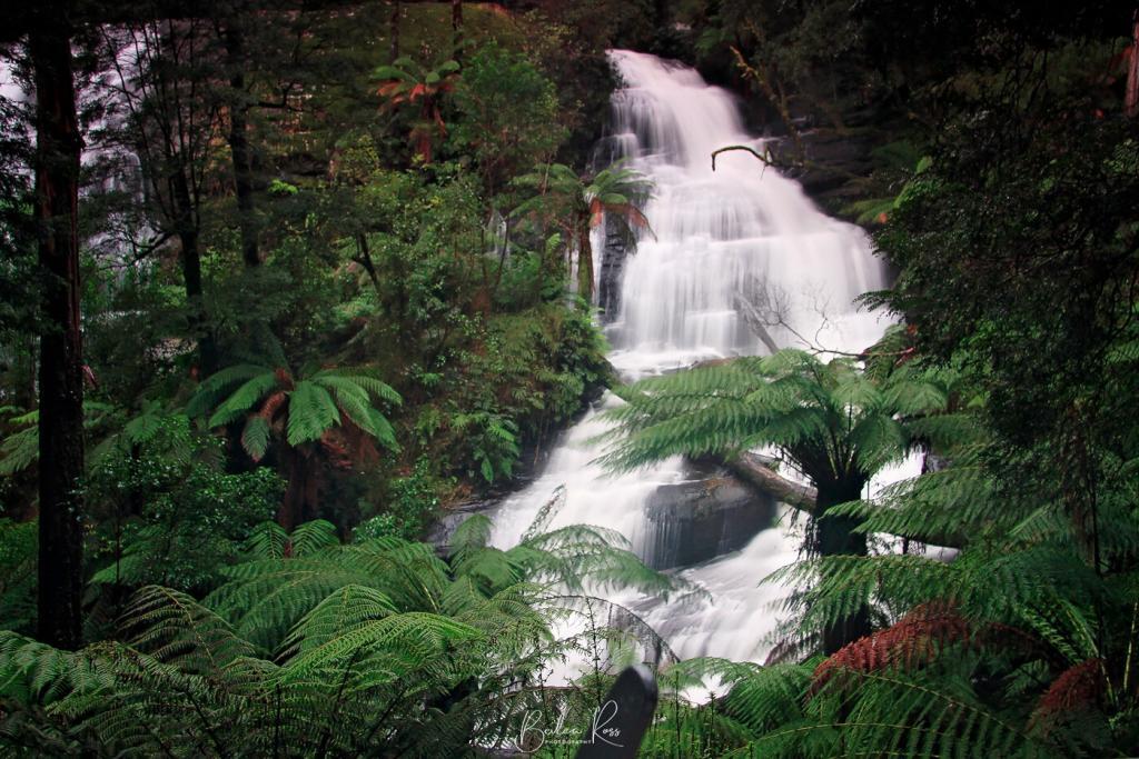
Saturday morning, we woke to rain and mist. Our first stop was Hopetoun Falls, very photographed but very photogenic. We spent about an hour there getting wetter and wetter before moving to Triplet Falls. The walk to both falls is reasonably straightforward. Hopetoun Falls has more steps, while Triplet has boardwalks all the way in. And we found there is a short way and a long way. Hopetoun Falls is also the most photogenic of the two. Unfortunately, Parks Victoria doesn’t signpost, which is the shorter, and we spent about 45 mins walking in a long way, only to find we were about 10 mins from the carpark taking a different path back!

The Otways are beautiful and totally worth multiple trips back. Don’t go in the middle of winter like we did unless you are happy with wet conditions.

After a terrible night of almost no sleep at the Daintree River Village Lodge (I really should learn to travel with my own pillow!), we were up before the sparrows and down on the Daintree River Jetty by 6 am, still in the dark. The light came pretty quickly, though, and by the time we pushed off at 6.30 am, it was light enough to see. We took a cruise with Ian ‘Sauce’ Worcester,
Cape Tribulation Rainforest
Cruising up the various arms of the Daintree and up to the Barretts Creek bridge that you drive across to enter the village was a silent and serene experience. Cape Tribulation Daintree Rainforest expands over 1200 square kilometres and is the largest area of continuous tropical rainforest in Australia. It is believed to be around 135 million years old. It is also considered to be one of the most ancient and primitive rainforests in the world. The river is totally still and silent save for the occasional bird call… it was like entering a prehistoric world. The river banks are totally overgrown with lush vegetation and bring to mind what I would expect the Amazon to look like. I wouldn’t be surprised to see a native with a dart gun peering out of the trees).


Daintree River

Ian is an extremely knowledgeable guide with eyes like a hawk. How he spotted birds and snakes from a moving boat camouflaged was a skill to behold. We saw plenty of wildlife on the cruise, including Crocodiles, Tree Snakes, Sacred Kingfisher and Ulysses Butterfly. However, in a small moving boat, none are easy to photograph, especially the crocs. As soon as they slithered off the bank into the river, Ian throttled up and got out of dodge 😉


Hartleys Crocodile Farm
Returning to the jetty, we packed up our room, headed to civilisation, and headed back down the Captain Cook Hwy to Cairns, stopping at Hartleys Crocodile Adventures for yet more crocs.
Hartleys, while commercial, is extremely good. The entry price is fair, and their cafe serves some of the best food we had while in Cairns at excellent prices. The entire place is outstanding value for money. We had a delicious lunch (chicken schnitzels and salad) and then boarded the lagoon cruise boat, which is included in your entry fee. The cruise is only about 15 minutes around the lagoon, but you get to see a jumping croc. They rise straight up out of the water. So scratch sitting in on a low-hanging branch tree as an effective haven from crocs in the wild.

With our croc adventures complete, we continued into Cairns and booked into our hotel. We had chosen the Hilton alongside Trinity Inlet for its proximity to the reef cruise centre and esplanade. The room was lovely, and the view was great, but the service was pretty average. If I get back to Cairns again, I won’t stay at the Hilton. We had a delicious meal on the esplanade returned to the hotel, and crashed out early (was becoming a theme, up by 5.30 – 6 am and in bed by 9 pm lol)
Next Morning.
was another gloriously sunny day, and we left the hotel by about 7 am and headed up into the Atherton Tablelands and Waterfall Way.

The first stop was Curtain Fig Tree in Yungaburra… it’s a HUGE old tree with a massive canopy. They are Strangler Fig trees with the fig seed dropped by birds on the top of a tree. It germinates and sends aerial roots, some as long as 15 metres, down to the ground, eventually strangling the original tree as it takes over.
Waterfall Way
From the Curtain Fig Tree, we headed to Ellinjaa Falls, a beautiful waterfall that’s about a 15-minute downhill walk from the car park. Getting back up was a little taxing, but not as bad as some I have been to.

We drove from Ellinjaa to Milla Millaa, probably the most famous waterfall on the Palmerston Hwy circuit. It’s got a lot going for it. It is stunning, and just over 18 metres tall. There is plenty of water pounding over the top, and a pool below it that’s popular to swim in. Even better, it’s right beside the carpark!

We left the tablelands late afternoon and headed back for Cairns, a hotel with thoughts of a shower, wine and dinner… and suitably accomplished all three before crashing out again at about 9.30 pm.

I have a strong fondness for Cairns and Far North Queensland (FNQ). In my opinion, the warm and humid tropics feel more genuinely “Queensland” compared to the typical tourist destination of Surfers Paradise. However, during my last visit in 2012, I unfortunately missed a few experiences. Therefore, I eagerly accepted my sister’s proposal to revisit and explore the area together.
Flight Out

We had an early flight from Melbourne, so we had to wake up at 3.30 am and leave the house at 4.15 am. Fortunately, we left early because we struggled to find the entrance to the long-term parking lot. The darkness and heavy rain caused us to miss it entirely, and we ended up back on the freeway. We had to take the next exit, return to the highway, and head to the airport. All the while, we were stressing about missing our flight! We finally parked the car, boarded the shuttle bus, and arrived at the terminal by 5 am.

Our flight departed on schedule, and we arrived in Cairns, FNQ, at 9:20 am. The weather was windy, but it was a pleasant change from the chilly 12C temperature we left behind in Melbourne. We stopped for lunch at the Wildlife Habitat in Port Douglas after breakfast.
Wildlife Habitat
The Wildlife Habitat has been around for 25 years. Besides the birds, the habitat houses Kangaroos, snakes, koalas, and crocodiles. The venue is beautiful and reasonably priced, and once you are in, there are numerous free shows to enjoy. However, I suggest skipping the buffet lunch and ordering something from the cafe instead. In my opinion, the lunch buffet was not very impressive.

After leaving Wildlife Habitat, we booked in to Thala Beach. Upon arrival, you drive up to the entrance, where you hand the keys to the valet and head inside. While they take your luggage to your room and park your car, you can relax and enjoy the view from the sitting area. All while sipping on your complimentary tropical punch.
Thala Beach

We were only at Thala overnight with our next stop, the Daintree River – so we called up for the golf buggy to take us to breakfast; while we ate, they took our luggage back to the car and then had the car waiting for us at the foot of the steps ready to drive off (gotta love the Thala VIP treatment!)

Mossman Gorge
Leaving Thala Beach, our first destination was Mossman Gorge. The place had undergone significant changes since my last visit. They now boast a beautiful new visitor centre and deluxe coaches that transport visitors from the centre to the gorge for a fee of $15. On my previous visit, we had to self-drive a bumpy, floodway-riddled goat track before squeezing into a small parking lot. Mossman Gorge, located at the southern end of the world heritage-listed Daintree Rainforest, is the oldest surviving rainforest in the world.

Below is the Rex Creek Bridge. It’s a swing bridge, and boy, does it swing. Trying to take a photo while standing on it is a challenge. People kept walking over it, and it would start swinging again. One step from the edge, and you can feel it instantly in the middle. It’s like trying to take a photo standing on jello. I waited for ages until traffic had left both sides, and it stopped wobbling enough to get the shot quickly.


Daintree River
We stopped in at the visitor centre on the way out for coffee and a muffin. Next, we drove up the Captain Cook Hwy again towards the Daintree, stopping at Daintree Cruise Centre, just before the village. We booked a 2-hour Croc Cruise with Adam on the Matilda II. Yes, I had the theme song of Gilligan’s Island stuck in my head for hours.

According to Adam, a veritable Crocodilia encyclopedia, the Daintree River has about sixty crocs. Which he said is a ‘low’ population, while Kakadu has more. But in his quote for the day, “It only takes one to ruin your day.”


Reflecting on my unforgettable journey through Cairns and Far North Queensland, I am grateful for the remarkable experiences and natural wonders I have encountered. From the vibrant coral gardens of the Great Barrier Reef to the lush rainforests of the Daintree, this region has left an indelible mark on my soul. Simply basking in the tranquillity of nature, every moment spent here has been a treasure. Until we meet again, Cairns and FNQ, thank you for the adventure of a lifetime.

I tried previously tried, to persuade Lucy to make The Great Ocean Road and Apollo Bay the focus of one of our weekends. The road is constantly referred to (by Lucy) as the “Great Scary Great Ocean Road” and a refusal to contemplate the thought of driving it. She finally succumbed to my begging and tantrums well-considered argument. And we booked a lovely two-bedroom unit in Apollo Bay with ocean views.
History
The Great Ocean Road is a “Heritage listed 243-kilometre (151 mi) stretch of road along the south-eastern coast of Australia between the Victorian cities of Torquay and Warrnambool. Built by returned soldiers between 1919 and 1932, it is the world’s largest war memorial dedicated to World War I casualties. It is also an important tourist attraction in Victoria.

The scary part comes into play as it hugs the cliffs, bending and twisting with white knuckle S-bends as it winds it’s way through varying terrain alongside the coast. It is a single-lane road with nowhere to overtake other cars, save for a few cutouts where people can pull over and allow others to pass. There’s also the sheer ocean drop to consider. Hence, her rampant paranoia is an understandable concern. However, the Great Ocean Road also provides access to several landmarks, including the nationally significant Twelve Apostles, a series of limestone stack formations.” There is a short excellent video history of the road HERE that’s well worth watching.
Erskine Falls
Our trip down started in the sunshine on Friday morning. A tad cold, but beautiful sunny blue skies. We stopped off in Anglesea for an early lunch and continued. There was a brief stop at the Split Point Lighthouse at Aireys Inlet, back in the car on into Lorne and then up into the hills to see Erskine FalUnfortunately, ls. Unfortunately, I had left my glasses in the car – so I didn’t get the best shot as I could hardly see the settings and was NOT going back to the car to get them! According to Parks Victoria, this was classed as a ‘moderate’ walk.

Three hundred twenty steps down to the falls mean 320 back up. It was touch and go as to whether we would MAKE it back up. I took lots of wheezy breaks trying to suck air into my burning lungs. Legs wobbly and refusing to go up another step. If we had mobile reception, we might have been tempted to call in the rescue chopper! 😉

From Lorne, we continued to Apollo Bay, collected our house keys and walked around the harbour. After enjoying the sun at the port, we headed back to our unit, ramped up the heating and settled in to do some art. Working on our journals, ATCs for a swap etc.,

Cape Otway Lightstation
The following day the sun had left us – it was very overcast and windy, but no rain was predicted, so we headed to the Cape Otway Lightstation. Driving along the road, the trees suddenly all looked stripped bare. It was a very odd sight. Then, we came across the culprit a bit further down the road. There is quite a large koala population. I don’t know what they plan to do when the food runs out cause the cupboard is bare!


Cape Otway Lightstation is the oldest surviving lighthouse in mainland Australia and has been in continuous operation since 1848. Life must have been terribly lonely and bleak there a hundred years ago. Cape Otway Lighthouse is perched above massive cliffs where the Southern Ocean and Bass Street collide, and it’s no summer picnic. Great view, but wind-swept and bitterly cold. However, spotting the cafe, we took refuge there for a serving of fresh scones with jam and cream and steaming hot coffee. After the climb to Erskine falls, we didn’t do the lighthouse climb. Though, compared to split point and Erskine, it would have been a breeze (it’s not that tall due to the height of the cliffs it sits on)

Gibsons Steps
From Cape Otway, we then drove towards Port Campbell. Gibsons Steps was our next stop. They are just before the Twelve Apostles and were initially a series of steps cut into the cliffside by Hugh Gibson (so he could get down to the beach to fish). They have since been replaced by 84 concrete steps – down to Gibsons Beach. Once on the beach, the limestone cliffs tower above you. Leaving Gibsons Steps behind, we were off to the Twelve Apostles. There are seven of them, not twelve (there have never been twelve). It was getting very grey with threatening skies. The sun came out briefly for a few mins at a time – but we could see a storm coming – and Sunday was predicted to be quite wet.


Twelve Apostles
From the Twelve Apostles, we went into Port Campbell for lunch. Apart from the pub, a cafe and servo, Port Campbell seemed to be closed. I expected it to be bigger, and for 2 pm on Saturday, it was deathly quiet and empty. We ate at the only cafe open – meals took almost an hour to arrive, and I was ready to walk out except that Lucy was chewing the table legs in hunger.
Once we wolfed our meal down, we headed back to Apollo Bay, bought dinner provisions, and returned to the unit just as the rain started. We had a good thunderstorm that night and brief sunshine again Sunday morning before the heavens opened again, and it kept raining quite heavily all day. So it’s a day for staying in and arting.

As had been the case every time we went away – Monday was bright, sunny and very nice in the sun. We left Apollo Bay a little before nine. I ate breakfast in Lorne and walked along the beach and through the rock pools. All in all, a delightful weekend. Our accommodation was very comfy. The weather was kind to us (considering it was winter, after all). We did art, ate junk food, talked, laughed and had a wonderful time.
Footnote:
In the months following our visit to the Cape Otway Lightstation, a secret koala cull was commenced to deal with the overpopulation. For more info, you can see the article Here.

Take One:
We planned a weekend away to Ararat with an Aradale Lunatic Asylum and J Ward visit and a side trip to The Grampians/Gariwerd. But, as they say in the classics, the best-laid plans of mice and men often go astray. Add women to that, too, vbg.
Gariwerd
The aboriginal name for the Grampians is Gariwerd. Gariwerd is a highly spiritual place for Aboriginal people due to the dreaming stories and the abundance of food, water and shelter it provides. This is evidenced by the number of occupation sites found in Gariwerd and that even today, Aboriginal people are drawn to this place. The Grampians/Gariwerd has the most significant number of rock art sites in southern Australia and over 80% of Victoria’s rock art sites.

Waterfall Hunting
We headed up the Western Highway towards Ballarat, veered off towards Horsham, drove through charming and quaint Beaufort (plan to go back there, lots of old photographic worthy buildings), lunched at the Cottage Garden Cafe in Beaufort scones with jam and cream. Yummy. We arrived in Ararat around 12.30 pm. As we couldn’t book into our accommodation until three, we decided, armed with all the maps, directions, and info from the Internet I had printed out, plus Lucy’s Tom-Tom, to head off and see a waterfall.
Mackenzie Falls
Initially, the plan was to see Mackenzie Falls, but as the Parks Victoria site said, the waterfall’s base was closed due to storm damage, and it’s not worth seeing a waterfall just from the top. So we drove off looking for Beehive Falls. And we’re still looking an hour later.
Backroads
Like the fabled Utopia, it’s out there somewhere but hidden behind the mists of time and lost travellers. We drove down Roses Gap Road (dirt road all the way) for over half an hour, stirring up a massive dust cloud behind us, and never found the ‘Roses Gap Car park that was on that road (according to the directions printed out) and never found Beehive Falls.
We did see some great views of the Grampians as we drove its length and breadth. But that’s as close as we got 🙁 As it was by now, around 2.30, we turned around and headed back to Ararat. After a brief but obligatory stop at MacDonald’s for a late lunch, we arrived at our cottage around 4 pm and loved it on sight.

Golf Links Retreat
We were greeted by our very hospitable hosts, Merren and Peter, who introduced us to the gorgeous cottage Golf Links Retreat we were staying in. Set in beautiful gardens, it’s a Bluestone brick exterior, old exposed brick walls and timber ceilings inside, a two-storey, three-bedroom, two-bathroom, breakfast basket, and Coonara heater. Heaven!!

We took the princess, too, and she took it straight away. It was ‘home’ for three days, and that’s just what it felt like. Home. We plan to go back and find those waterfalls next time, too!

Aradale
As Saturday was very wet and rained ALL day, we decided to stay in and do some ‘arting’. We took supplies with us and spent the day making gazillions of chipboard tiles that we would adhere to large canvases. Sunday was just as overcast and cool. But only brief showers, so we decided to head off to Aradale Mental Hospital. It started life named Aradale Lunatic Asylum. Take the tour (the link will give you all the info on it)

The outside was a beautiful, huge, massive complex of around 70 buildings. But inside, it had suffered from renovations in the ’50s and ’70s and wasn’t what I expected. It was more interesting once we got into the older parts.
J ward

Monday, we were heading home but stopped off and took the tour of J ward. J Ward started as a goldfields prison in 1859, and when the gold ran out, the ‘Lunacy Department’ (I kid you not) acquired it as a prison for the criminally insane. It housed the most dangerous and violent offenders deemed unfit due to mental issues to stand trial. They were detained at the Governor’s pleasure under the highest security (and lowest conditions). One famous inmate was Garry David Webb.


After our tour (very interesting with a very informative guide), we continued our journey back home. But, as I said, we plan to return to Ararat and the Golf Links Retreat to find those waterfalls and take the ghost tour of J ward!
Take Two:
Waterfall Hunting Again
Lucy and I returned to Ararat armed with better maps and a goal to see a waterfall in the Grampians finally. We had taken a wrong turn last time and travelled miles on a dirt road. This time, we were prepared. We drove straight to Halls Gap on Friday and saw Reid’s Lookout, The Balconies and a little McKenzie Falls (the track to the base was closed). However, the path to Broken Falls was open and more of our style (suitable for the fitness-challenged).
Broken Falls

The Falls are quite pretty, and I could see why they were named Broken Falls. The water plunges over the top but splits into several separate falls. Unfortunately, getting a good shot from the viewing platform was hard because quite a few trees blocked our view.
Watching the world go by
We were booked in at the Links Retreat B&B again, a charming little bluestone cottage alongside the golf course..we’d sit on the veranda and watch the golfers go by and putt around the kangaroos who were lifetime members. We took our art journals to work on, two big suitcases of supplies, and a small bag of clothes each. I should have taken a pic of the table as we worked on them. Maybe we did not think our hosts would have had a heart attack at the mess we made (but we cleaned up before leaving).

McKenzie Falls Again
We returned to the Grampians – Gariwerd and McKenzie Falls via Stawell for breakfast on Saturday. It was a sunny but cool morning, but unfortunately, it was raining quite a bit up in the hills, and I didn’t get a shot of them (Lucy did use my tripod, which we were sharing, but the rain came down in buckets as she finished so we packed it in) and we returned to Ararat for lunch. At least, that was the plan.
Unfortunately, Ararat shuts at 1 pm on Saturday. Almost nothing is open. There were no nice cafes except for MacDonald’s, which we were sick of. So we ate a lovely Subway lunch before returning to our cottage to art for the rest of the day.
Sunday in Ararat’s bustling town of 8200 very sleepy people, it seems Ararat was deserted and dead at 11 am. Few shops were opening, but there was minimal Sunday trading in Ararat. Of course, it’s not the world’s end, but you can see it from there.
One Tree Hill
Sunday night, the sun shone, so we headed up the road to One Tree Hill, an odd name for something covered in trees, but that’s country folk for you. We timed our visit to coincide with sunset; the view was beautiful.

Monday morning, I was back on the road home. Our art journals had quite a few pages done. We had a lovely time. And we made two new resolutions. First, never visit somewhere with lousy internet access; second, make sure the town stays open past 1950).
