Tag:victoria

In 2009, following weeks of drought and extreme heat, Victoria was a tinderbox waiting for the match to fall. The devastating bushfires that swept across Victoria on February 7, 2009, now famously known by all as Black Saturday, was the realisation of that nightmare. Just 95km from Melbourne via The Black Spur, Marysville was almost wiped from the map that day. However, Marysville has risen from the ashes in the thirteen years since then.
Black Saturday
The Black Saturday fires started on February 7, with over 400 burning across victoria. It remains the worst bushfire regarding lives lost in Australia’s history to this day. The fires followed an extreme heatwave, coupled with low humidity. This led to Melbourne enduring 43°C for three consecutive days, reaching 46°C on Saturday. As a result, Premier of the day John Brumby issued a public warning that Saturday was expected to be the “worst day for fire conditions, in the state’s history”.

On Saturday, Victorians woke to winds above 100km an hour, bringing hot air down from Central Australia. The Kilmore East/Kinglake fire began at 11.47 am when the winds brought down power lines at Kilmore East, and the sparks ignited the dry grass. Crucially, that single powerline fault led to the deaths of 119 people within hours.
Fire Outbreaks
By 1.58 pm, the Kilmore East fire had burnt through light forests and grassy paddocks. It threatened homes at Wandong before heading towards Mt Disappointment. The strong winds blew embers as far as 40 kms ahead of the main fire front, causing spot fires to break out. By 7 pm, it entered the Kinglake National Forest. As a result of a wind change, the eastern flank suddenly became the fire front, and the town of Kinglake came under heavy ember attack.
The Murrindindi fires that decimated Marysville began near the Murrindindi Mill at 3 pm before spreading through the Murrindindi State Forest and Black Range. After burning through Narbethong, it hit Marysville at 6.45 pm before burning through Buxton and Taggerty. A coronial inquest into the Murrindini fire found it began with the failure of AusNet electricity poles 5 and 6 and broken conductors lying across a fence on Wilhelmina Falls Road, Murrindindi. As a result, the fence became electrified and ignited the vegetation. This fire resulted in the loss of 500 properties and the deaths of 40 people at Marysville, Buxton and Narbethong. Ausnet settled a claim for $260m without admitting liability.

Stastistics
The statistics are heart-rending. 173 lives were lost, 120 in the Kinglake area alone. A further 414 were injured, 3,500 buildings were lost, including 2,029 homes. The RSPCA estimated up to one million wild and domestic animals perished. 200,00 trout boiled in the water at a trout farm. Fires ranged over 450,00 hectares of land. The 400 homes and buildings lost at Marysville included the primary school, police station, Bruno’s Garden, the Cumberland Guest House and Steavensons Falls infrastructure. Arson was the cause of most of the bushfires. However, some fires resulted from collapsed power lines in the 100km winds that day, and lightning strikes also started other fires. Burning for 26 days, the Murrindindi forefront that decimated Marysville was not extinguished until March 13.
The Kinglake Fire Complex was the most significant fire which evolved from the merging of the Kilmore East and Murrindindi fires on 8 February. It swept through state forests and national parks with flames recorded at 30 metres in height.
National Museum Australia
In the years since businesses have rebuilt, Marysville is once again a thriving community, with gardens, wineries, golf course, trout farm and galleries. Two of my favourites are Steavensons falls and Bruno’s sculpture garden.
Steavensons Falls
A short 4kms out of Marysville on the Steaveson River will bring you to one of the tallest falls in Australia. The bushfires of Black Saturday destroyed all of the picnic areas, toilet blocks, walks and paths etc. and decimated the surrounding forest. Parks Victoria has since rebuilt new amenities blocks and added new paths and walking tracks.

The falls are an easy 700-metre walk from the carpark with improved paths and infrastructure. Steaveson Falls has five cascades and plummet 84 metres into the Steavenson River. The cross-flow turbine generates electricity and powers the lights on the falls from dusk to 11 pm.

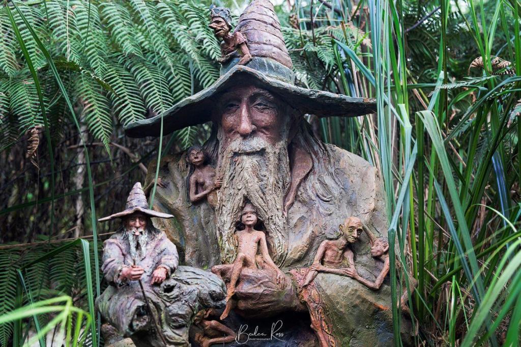
Bruno’s Art and Sculpture Garden
It was days before the residents of Marysville were allowed back to the remains of their shattered town. When Bruno returned, he found his Art and Sculpture Garden a blackened, charcoal wasteland. Gone was his home, workshop, and years of work.
With the help and support of family, friends, and strangers from across the globe who had visited and loved the garden, Bruno began the painful task of rebuilding. First, Bruno repaired the Sculptures and since then added new ones. Thirteen years later, it is again a lush wonderland with barely a trace of the devastation that was. The garden is a testament to a skilled artisan’s tenacity and fertile imagination.


Where to find it?
Bruno’s Art & Sculpture Garden, 51 Falls Road Marysville, 3779
Adult entry is $10 for the garden ($15 if you include the gallery). Under 16 is $10, and for children under five, it is free.
The garden is open seven days a week from 10 am to 5 pm. The gallery is open Saturday, Sunday and public holidays.
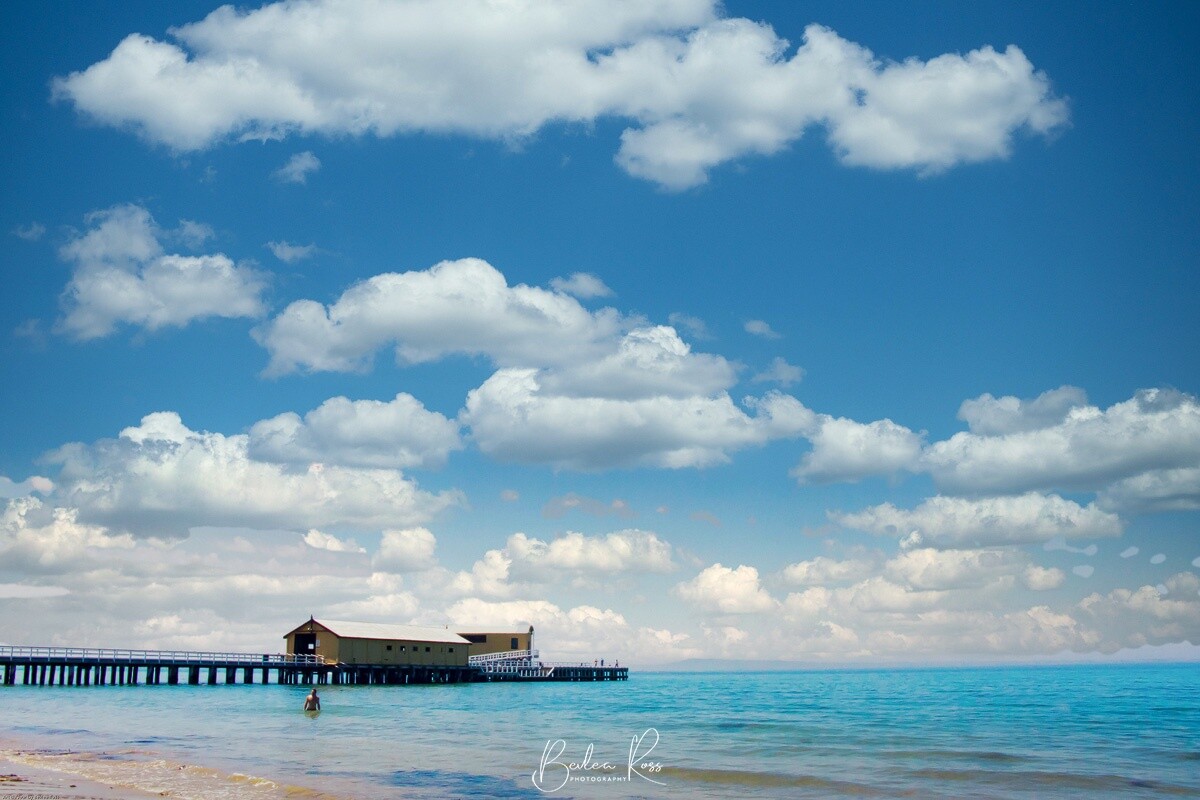
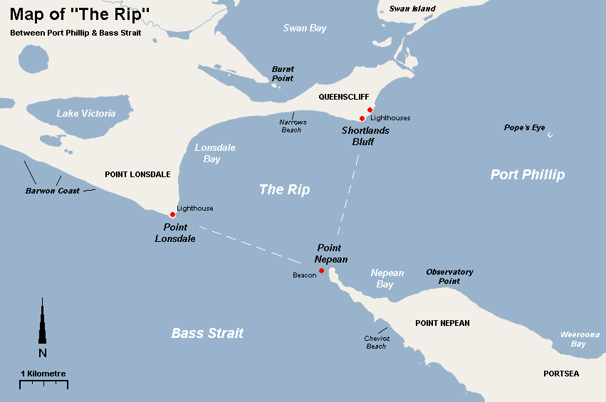
The historic town of Queenscliff is situated on Victoria’s Bellarine Peninsula 90 minutes from Melbourne. Nearby is Point Lonsdale (and a third lighthouse). Surrounded on three sides by water, Queenscliff is a popular seaside resort. It is known for its Victorian-era heritage-listed buildings and two lighthouses.

History
In January 1802, the first European explorers arrived with Lieutenant John Murray. This was followed by Captain Matthew Flinders in April. The first European settler was escaped convict William Buckley in 1803. Buckley briefly lived in a cave with local aborigines at Point Lonsdale, above which the lighthouse was later built. In 1836, permanent settlement began with the arrival of squatters. The area was then named Shortlands Bluff in honour of Lieutenant John Shortland who had assisted in the surveying of Port Phillip. In 1853 Lieutenant Charles La Trobe renamed the area Queenscliff in honour of Queen Victoria.
Originally a fishing village, Queenscliff evolved into a major cargo port servicing steamships trading in Port Phillip Bay. In 1841, a shipping pilot service was established to lead the boats through the treacherous rip that runs through Port Phillip Heads.

The Notorious Rip
The ‘rip’, also known as “The Heads”, is a narrow waterway connecting Bass Strait to Port Phillip Bay and is the only maritime route providing access to Port Phillip Bay. While the entrance between Point Lonsdale and Point Nepean is 3.5km wide, protruding reefs reduce the shipping channel to only 1km wide. In addition, large tides flow through the narrow channel from the bay to the ocean; this, coupled with the high rocky sea bed, puts it on the list of one of the ten most treacherous navigatable passages in the world. It’s a passage that has claimed many ships and lives. As a result, two lighthouses were added at Queenscliff in 1862-63, the High Light and Low light, with the Pt Lonsdale Lighthouse and foghorn added in 1867.

Lighthouses
The High Light, also known as the Black Lighthouse, is situated on the grounds of Fort Queenscliff. It is one of only three black lighthouses in the world and the only one in the Southern Hemisphere. The Low Light – a White lighthouse stands at the entrance to Port Phillip from Bass Strait, overlooking the ‘rip’. On either side of the White Lighthouse are two skeletal towers showing red and green lights that blink in unison, defining the correct course through the Rip.

Tourist Boom and Decline
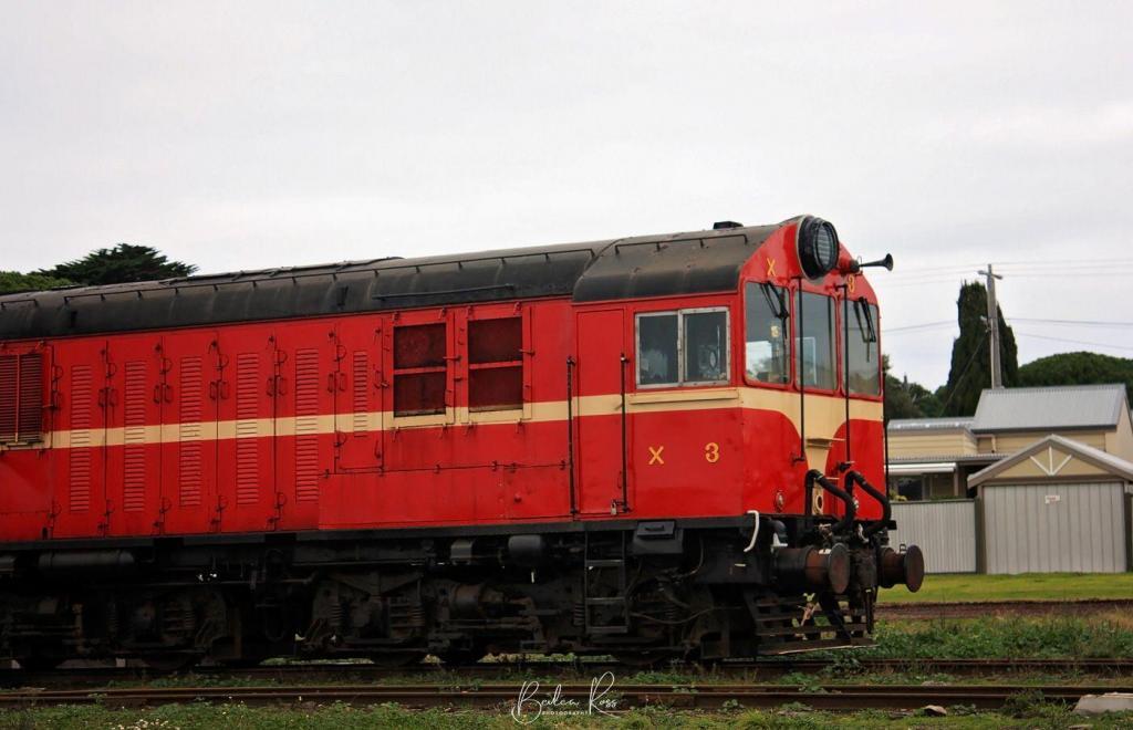
In the late 19th century, Queenscliff boomed with visitors arriving from Melbourne after a two-hour paddle steamer journey. The railway line opened in 1879, bringing more tourists, and numerous luxury hotels sprung up to accommodate the influx of visitors. However, with the advent of the car, Queenscliff entered its decline, as tourists could now drive themselves anywhere within the state and were no longer reliant on Queenscliff as a transport hub. As a result, the railway ceased weekly passenger services in 1950. Instead, the train now operates passenger service between Queenscliff and Drysdale, with diesel and steam trains for the Blues Train, Day Out With Thomas Weekends, Santa Trains and Charter Experiences.
Revival
In the 1980’s tourism again turned its sights to Queenscliff. As there is no bridge connecting both sides of the bay, in 1987, the first Searoad ferry carrying 35 cars and passengers connected Sorrento with Queenscliff. This turned a 211km/3hr drive into a one-hour sea road in comfort. In 1993 a larger ferry, the M.V Queenscliff, commenced service, doubling the vehicle capacity and providing greater comfort for passengers. Searoad Ferries now run two ferries on an hourly service from Queenscliff to Sorrento, with a ferry leaving each side on the hour and passing each other in the bay.


Heritage Buildings
Listed on the Victorian Heritage Register are the following Queenscliff buildings:
- Fishermans Shed – I Weeroona Parade and 2 Wharf St
- Lathamstowe – built as a sanatorium for the Anglican Clergy
- Ozone Hotel, 42 Gellibrand Street – now converted to apartments
- Pilots cottages – 60-62 Gellibrand Street – built in 1854 for the sea pilots of Port Phillip
- Queenscliff Hotel – 16 Gellibrand Street
- Wreck Bell, Corner of Gellibrand and Wharf Streets
- Fort Queenscliffe Museum, Cnr of King and Gellibrand Streets
- Queenscliff Pier and Lifeboat Complex, Symonds Street,
- Queenscliff Railway Station – 20 Symonds Street
- Rosenfeld, 26 King Street,
- Roseville Cottage, 42 Mercer Street,
- Warringah, 80 Mercer Street
- St George the Martyr Church and Parish Hall, 16-26 Hobson Street


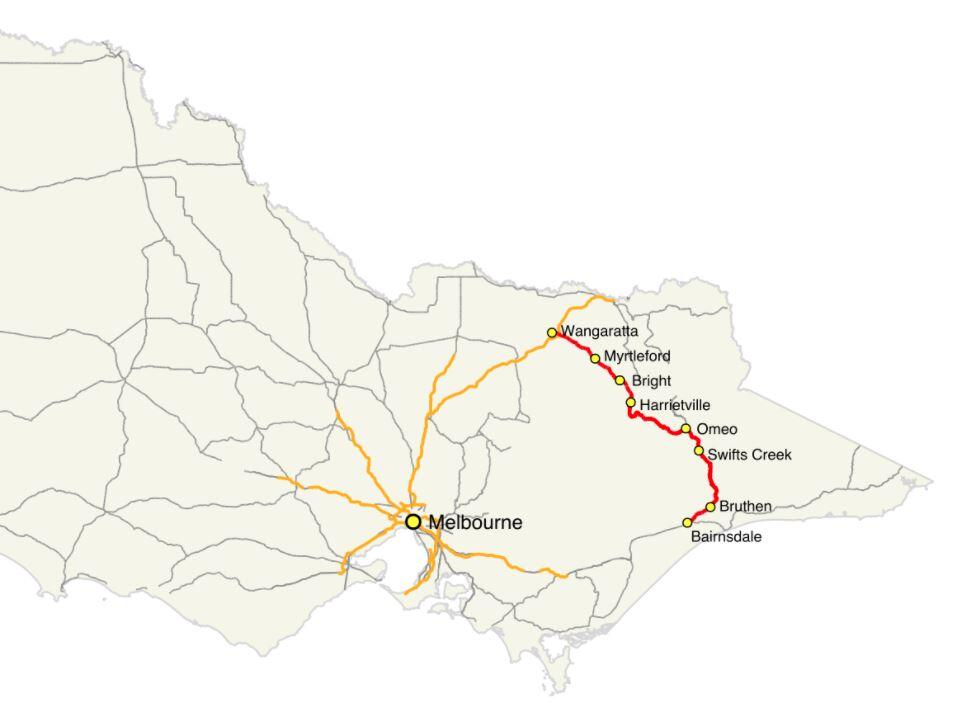
Victoria’s Great Alpine Way is one of the most scenic drives in the world and belongs on everyone’s bucket list. It is 304km long and starts in Wangaratta. The road travels through Myrtleford and Bright before winding its way up and through the Victorian Alps before terminating at Metung in Bairnsdale. It passes through mountains, valleys, forests, rivers, farms and vineyards. Like its coastal cousin, The Great Ocean Road, it hugs cliffs and clings to ridges providing spectacular views at every turn. The Great Alpine Way is Victoria’s highest sealed, year round, accessible road.
History
The Bright to Omeo section was upgraded in 1883 from packhorse to a wide road to allow horse-drawn coaches. It carried goods and people to the Ovens Valley, Omeo, Cobungra and goldfields. The route was a combination of the Ovens Highway and the Alpine Road and was renamed the Great Alpine Way when the final section was sealed in 1998. It’s a drive that requires respect. The Harrietville to Mount Hotham section is particularly steep, with a few extreme hairpin bends with sheer drop-offs requiring extra care in that section.

As it passes over Mount Hotham, the road has an altitude of 1,840 metres, carpeting it with snow in winter. Snowploughs clear the road daily. Extreme conditions still see the road closed from time to time. Take the road slow. It will be safer and allow you to enjoy the spectacular scenery.

Which Direction?
Which is the best way to do it? Southeast from Wangaratta to Bairnsdale or northwest from Bairnsdale to Wangaratta? The main factor in your decision is the sun. Between April and September, the sun is lower in the sky and taking the bends or going over crests will be more problematic if not downright nerve-wracking driving into the sun. Driving late morning/early afternoon Wangaratta to Bairnsdale is the best option as the sun will be behind you. The views and photography are much better if not shooting or squinting into the sun. If you are travelling early morning – then Bairnsdale to Wangaratta is better.


Mount Hotham
Mount Hotham, named after Charles Hotham, Governor of Victoria from 1854 to 1855, is Australia’s highest alpine village. With its short, cool summers and long, freezing winters, Mount Hotham’s climate is Subantarctic.


Planning on a few days to do it? NRMA has a great itinerary
Wallaces Hut

As you drive through Falls Creek, keep your eye out for Wallace’s Hut. Park in the Wallace’s Hut parking area and walk 750m down the path to the hut. The three Wallace brothers built the oldest surviving cattlemen’s hut in the Victorian Alps was built in 1889 by the three Wallace brothers. The family had a large ‘run’ at Kergunyah near Beechworth and grazing land on the banks of the Kiewa River. As was the custom, they took the cattle up the mountain to fatten the herd over spring and summer, allowing the home pastures to recover from the Winter.

Bogong High Plains
In 1889 the three brothers took a herd up to the Bogong High Plains. While there, they decided to build a hut to shelter from the extreme mountain weather. They searched for a site sheltered from winds. But one was close enough to water and firewood before choosing a site nestled among snow gums with a rocky outcrop at the back. They constructed the hut from snow gums and used straight mountain ash as roof shingles. The roof pitched at a steep angle to ensure snow wouldn’t settle heavily on it. Finished in six weeks, it measures just 6.3 mt x 3.5mt.
Wallace’s hut is now classified by the National Trust, owned by Victoria, and managed by Parks Victoria.

Australia’s largest flying Bird – The Pelican, is a familiar sight along the Australian coast. It is often seen roosting on sandbanks, rocky breakwaters, swimming in lagoons, bays and rivers, and congregating in large numbers around fishing villages or where fishermen clean their catch. They are large waterbirds with a long pink bill for catching fish and draining the scooped up contents before swallowing.

Appearance
Pelicans species are mainly white except for the brown and Peruvian pelicans. The Australian Pelican is the largest of all eight pelican species. However, it weighs just 7kg because it has the lightest bones of any bird in the world, with air sacs in the bones and a network of air sacs under its skin. Their bill, the largest of all the Pelican species, is 40-50cm long, and they are voracious eaters, consuming up to 9kg of food per day eating fish, shrimps and yabbies.

With a wingspan of 2.3 – 2.6, they can soar to a height of 3000m and fly 1,000 in 24 hours. They are found throughout Australia, Papua New Guinea and western Indonesia, with occasional reports in New Zealand and various western Pacific islands.

Behaviour
Pelicans plunge their bills into the water to catch their prey, using it as a net to scoop up prey. While they may feed alone, they more often work together to drive fish into a concentrated mass before herding the fish into shallow water or ever-decreasing circles. On a trip to Lake Menindee one year, we went out to shoot a sunset at the local weir. We found a flock of pelicans waiting at the wall for dinner on arrival. As fish swept over the top of the weir, they would scoop them up at the bottom. Pelican version of automatic food dispenser 🙂


During food shortages, they have been known to capture and eat seagulls or ducklings, holding them under the water until they drown and then eating them head first. They will also rob other birds of their prey and take handouts from humans.

Mythology
Pelicans also feature in many myths and Christian iconology, including the ‘Book of Beasts”, a Christian compendium of real and imaginary beasts, with the Pelican symbolising selflessness and sacrifice. Colin Theile wrote the beloved Australian book ‘Storm Boy’, the story of a young boy living a lonely life with his reclusive father on the beach in Coorong, an isolated wetland region in South Australia. The boy finds and raises three orphaned Pelican chicks forming a close bond with them. In 1976 the book was adapted into a film, with a sequel in 2019. Mr Percival, the Pelican, died in Adelaide Zoo in 2009, aged 33 years old.

Breeding Site
All Australian pelicans mainly derive from just two breeding sites. On islands in the north of the Coorong, S.A. – Storm Boy country – the rookery produces almost all of Australia’s pelican chicks. The other is on various waterways of the Lake Eyre basin during rare flooding events. This year there was also a large breeding colony on Lake Brewster NSW, a remote inland lake.
In 1990, around 100,000 pelicans (perhaps a third of all the pelicans in Australia) on Lake Eyre produced 80,000 to 90,000 chicks, which later dispersed throughout the continent, including Canberra’s lakes.
About Regional

Breeding
Pelicans are gregarious birds and are monogamous for a single season, breeding in large colonies. While up to four chalky white eggs are laid, the usual number is two. Incubation is for 32 to 35 days. After hatching, the larger chick is fed more, and the smaller one eventually dies of starvation or siblicide by the other chick. The young Pelican can fly at around three months of age but still depend on its parents for food.

Landing and Take Off
Pelicans can remain in the air for 24 hours. However, they cannot sustain flapping flights over long periods. They use thermal currents to swoop and soar and cover great distances to overcome this. The landing appears similar to an amphibious aeroplane landing on a water runway, gliding to a stop using its webbed feet as brakes. Then, they skim across the water on takeoff, building up speed, flapping wings, and lifting into the air.
Pelican Feeding
Where can you see Pelicans being fed? Every day at midday on the foreshore by the pier at San Remo, Vic. The Pelican feeding at The Entrance in NSW has been temporarily halted due to Covid. You can see them fed at Ian Dipple Lagoon on the Gold Coast at 1.30 pm daily. The pelican feeding has been permanently cancelled at Kingscote, Kangaroo Island, SA.


Seven km south of Rushworth and ten km south-west of the Waranga Basin reservoir lies the abandoned gold mining town of Whroo. The name is pronounced ‘roo’ and comes from an Aboriginal word meaning lips. The town is completely gone with little evidence of its existence, save for Whroo cemetery. The final resting place of 400 of the town inhabitants. Whroo is abandoned but not forgotten as the Whroo Cemetery trust works to restore the graves.
Gold!
In October 1854, the year after Rushworth, two sailors, John Thomas Lewis and James Meek Nickinson discovered gold at Whroo on Balaclava Hill. Balaclava Hill was a rich field and was later mined by open cut. The call of gold brought thousands of miners to Whroo; however, the population had shrunk to around 450 by 1858.
By 1865 Whroo had a flourishing gold mining industry. Serviced by a mechanics’ institute, library, two churches, three hotels, a cordial factory and three ore crushing mills. By 1933, at the last census, the population had dwindled to 52, and by 1955 it was a ghost town. Walking there today it is a silent, empty place of dry, dusty earth and ironbark forest.

Whroo Cemetery
The Whroo cemetery epitomises the difficulties of living in a harsh, unforgiving environment before modern medical care. Regardless of status, health, age or nationality, a simple illness or accident led to death. Chinese miners account for 15% of 400 graves. The Chinese were a significant part of the community as miners, puddling machine operators and market gardeners. Of the 400 graves, only around 200 names have been identified by the Whroo cemetery trust due to the deterioration of the grave markers.

Many of the graves are of children. These were either stillborn or died when Diptheria, Typhoid or dysentery swept through the town. Tuberculosis was also a common cause of death at the time. Among the graves is six children from one family. The eldest of which was a girl who died at just two years old. Their mother is also buried with them, who passed in her early 40s. Other graves as those of miners who died of illness or mining accidents

The cemetery trust is working on naming all the graves, and to that end, it has unveiled a new plaque with the names of all those interned there.


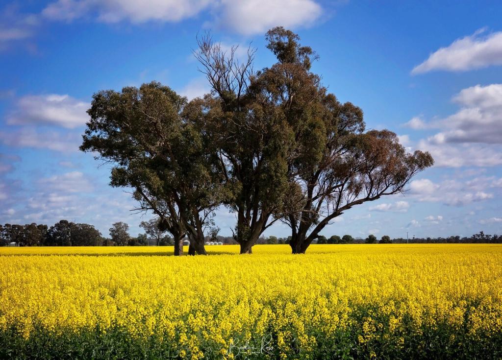
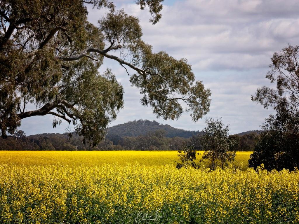
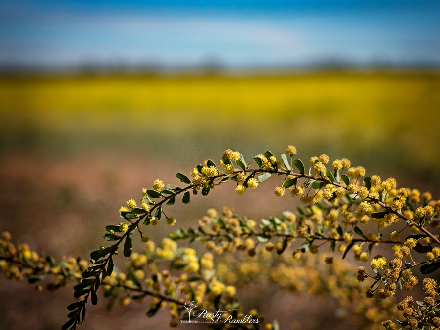
Spring means Canola! As far as the eye can see, Victoria’s amazing fields of gold are blooming. Also in flower are fields from Western Australia’s Wheat Belt, South Australia’s Clare Valley, NSW’s Riverina and Central West, and Victoria’s South West are ablaze with blooming yellow Canola fields. Blooms are at their best from mid-September through to mid-October. The yellow blooms attract many Instagrammers and photographers each year, and it’s not hard to see why, with brilliant, bright yellow flowers set against colourful Australian landscapes.

This year in Victoria, growing conditions have been perfect, and farmers are gearing up for a bumper harvest. But, with this year’s lockdowns, I would hazard a guess that farmers are also very relieved that those same Instagrammers and photographers can’t trample their fields looking for the perfect shot.

Canola (Brassica napus L.) is an oilseed crop created through plant crossbreeding. Scientists in Canada developed an edible version of the rapeseed plant, which — on its own — harbors toxic compounds called erucic acid and glucosinolates. The name “canola” comes from “Canada” and “ola,” denoting oil
Healthline
While no cooking oil is “healthy”, Canola is the world’s healthiest cooking oil, second only to Olive Oil. Our bodies require fat – but some fats are healthier than others, and Canola provides more ‘good’ fats than bad. It’s a rich source of Vitamin E, is cholesterol-free and contains the least saturated fat than many other common cooking oils. Canola also has many non-food uses, such as biodiesel and bioplastics. In the US, it is also used in baby formula. In addition, the Canola meal – the part left over after the seeds are crushed and oil extracted, is used for animal feed, pet food and fertiliser.
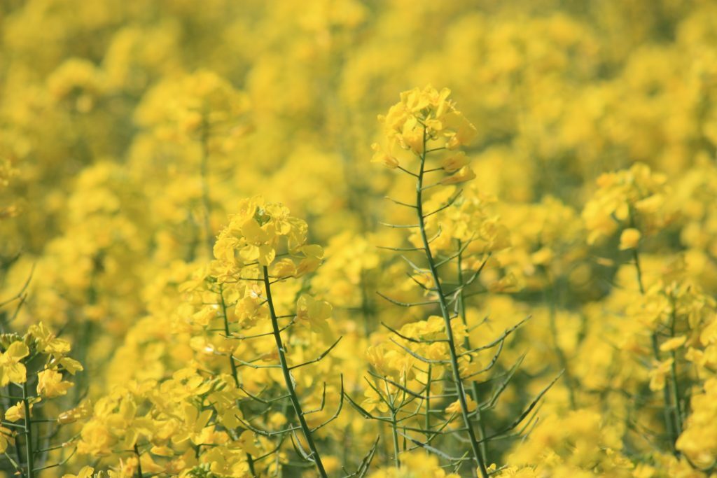
the canola plant
Canola is a herbaceous plant growing between 1 to 2 metres in height. The leaves are oval-shaped and hairy at the edges, with small yellow flowers that are a rich source of nectar that attracts bees. The flowers are capable of self-pollination – when cross-pollination is not available. The seed-containing pod is similar to a pea pod but five times smaller. Each pod contains 20 black or brown round seeds and contains 40% oil. It takes 22.5kg to make 10 litres of oil
Two types of protein are extracted from the Canola meal – these are used industrially in sports drinks and protein-enriched foods. Compounds isolated from canola are used in the cosmetic industry for soaps, lipsticks, anti-aging creams and moisturizing lotions. Two types of resins isolated from canola are used in the manufacture of ink

Locations
Where are these amazing fields of gold? In Victoria, you will find canola around Little River and Bellarine Peninsula, in Sunbury, along the Western Highway, heading towards the Grampians, Ballarat, Rokewood and one of the largest fields in the area, near Lexton. They also line the Goulburn Valley Highway to Shepparton and are plentiful around Nagambie and Dookie.

Safely Photographing Canola
- Look, but don’t touch! – Walking on or among the fields causes crop damage
- Don’t enter private property without permission – the perfect selfie does not justify trespassing
- Only pull over where it is safe to do so
Tips for Photographing Canola
- If you want wide-sweeping vistas, a wide-angle lens will be needed. However, if you don’t own a wide-angle, either stand further back to include more of the scene – or shoot a pano.
- Another good lens to have on you is a zoom – the fields rarely have public access, so standing behind the fence, you will need a zoom lens to get closeups of the flowers. (All of my shots were taken with a zoom lens)
- Most fields have roads or paths quite close, so you can easily shoot over the fence. If you can’t get close enough, pull out the zoom
- Use a slower shutter speed for creative blur if it’s breezy
- Use a polarizing filter to enhance contrast
Best Weather And Time of Day
- Look for side lighting – and avoid backlit scenes
- It’s spring, which means it’s windier than at other times of the year. Try to pick a still day or enjoy the view while you wait for the wind gusts to stop.
- Partly cloudy days will give you lovely sunshine, so the canola flowers pop, but also ensure the sky is interesting with some puffy clouds. Dark skies of approaching rain – but the sun still shining are fantastic. But rare 🙁
- Sunrise and sunset also work great. Either use an ND Grad to bring the sky down or bracket your shots
- Look for tractor tracks for leading lines and trees to pull the eye into the photograph.
- Foreground interest – gates and fences
- Shoot at F8 and above to get front-to-back sharpness
- However, if you are super close to the canola, focus stack to avoid foreground blur
NOTE: An update to this post can be found on Goulburns Golden Blanket
Good luck with your hunting the Canola, Victoria’s Fields of Gold.

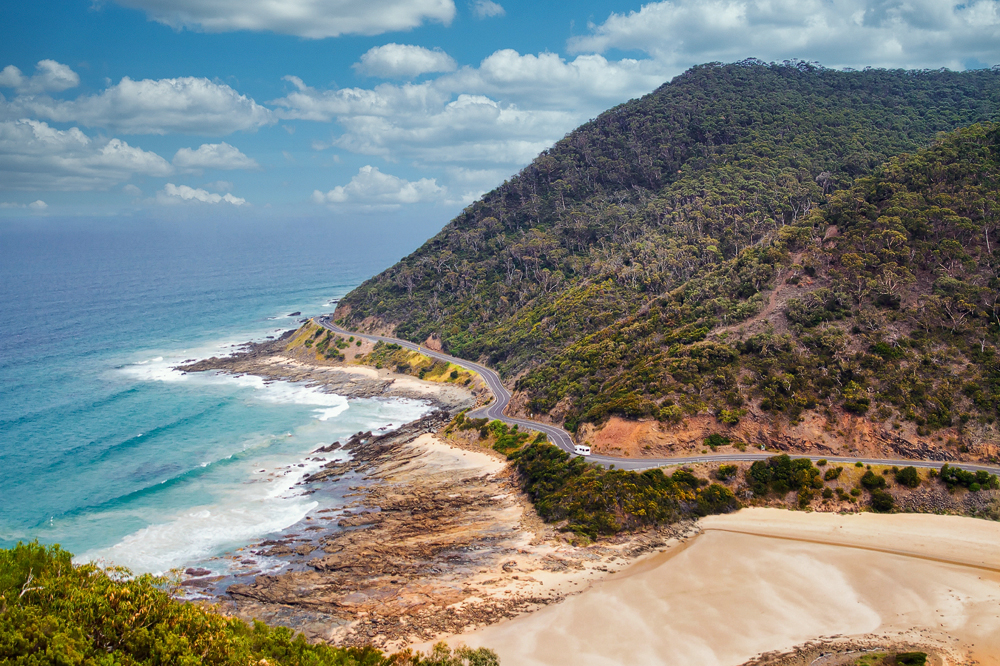
Victoria’s shipwreck coast stretches 172 kilometres from Cape Otway to Port Fairy. Along this spectacular coastline, filled with the history of over 200 shipwrecks, you will find rugged cliffs, impressive limestone rock formations, sandy bays, and raging surf beaches.

The ‘shipwreck coast’ lies within the world famous ‘Great Ocean Road’ snaking along cliffs past stunning surf beaches, Gibsons Steps, Twelve Apostles, London Bridge, Loch Ard Gorge, etc. The Great Ocean Road ultimately spans 400 km. It begins in Torquay and ends at Nelson on the South Australian border.
Shipwrecks
Bass Strait was the major shipping route for ships to Victoria. The early wooden sailing ships, and later the steam-powered metal ships, took the Great Circle Route around Cape Town before heading across the Southern Ocean towards Bass Strait. The most treacherous part of the voyage was the ‘eye of the needle’ at Cape Otway. Over 200 ships sunk between Cape Otway and Port Fairy
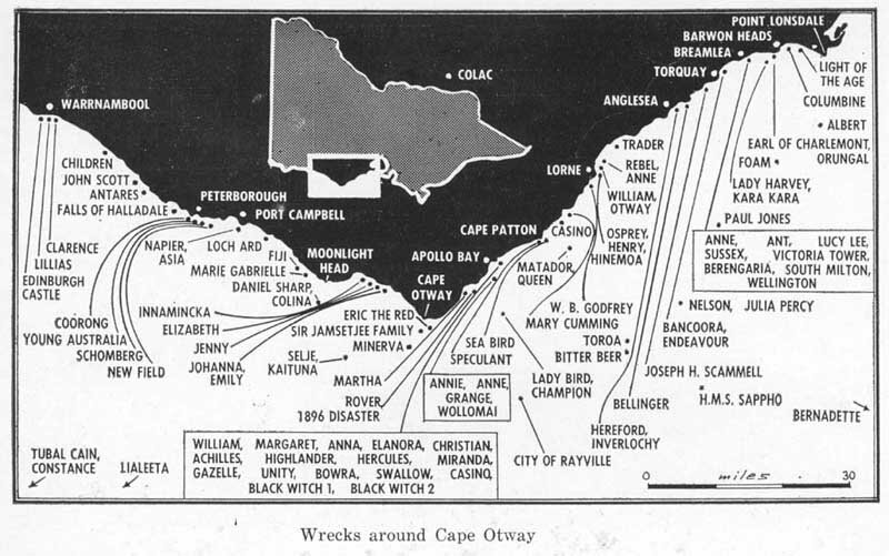
Sinking of the Cataraqui
Australia’s oldest surviving lighthouse, the Cape Otway lighthouse, was built in 1848 in response to the loss, in 1845 of the Cataraqui and 400 deaths off the coast of King Island. The Cataraqui was a 73m long barque that left Liverpool bound for Australia. Aboard were 411 people emigrating from the UK and Ireland.

At 4.30 am, in stormy weather, the ship hit a reef on the west coast of King Island, less than 100 metres from shore. By morning, the 200 surviving passengers and crew still clung to the deck, but the ship broke in two mid-afternoon, flinging survivors into the raging waters. Only nine made it to shore floating on debris. One passenger and eight crew. They sheltered on King Island for five weeks before a passing vessel, the Midge, rescued them and took them to Melbourne. The admiralty then banned ships using Bass Strait until the lighthouse was constructed.
Cape Otway
Known as the ‘Beacon of Hope’, Cape Otway is Australia’s most significant lighthouse. The beacon shines out over the Bass Strait shipping lanes. Constructed of sandstone, it was so well shaped that no cement was required to hold the tower together.

The Lighthouse
The lighthouse was the first sight of land for thousands of 19th-century migrants who had spent months travelling to Australia. The 84km gap between Cape Otway and King Island is known as the ‘eye of the needle’. Ships would hug the victorian coast to avoid being driven, in bad weather, onto reefs around King Island. However, reefs also around Cape Otway led to many ships foundering.
The lighthouse was extraordinarily isolated and received supplies only every 12 months until 1859, at which time they increased to twice a year. The lighthouse lantern was manufactured in London and consisted of 21 polished reflectors and lamps mounted on a frame. Originally running on oil, later converted to electricity, the light has been decommissioned and replaced with solar power.

Wreck Beach
Within the Great Otway National Park lies Wreck Beach. Considered a challenging walk, it’s 350 steps down to the beach where the Marie Gabrielle and the Fiji anchors lie. Both ships foundered at Wreck beach, and it’s not hard to see why. But, unfortunately, it’s only accessible at low tide and subject to large swells.

Gibsons Steps
Continuing westward along the great ocean road and 27 kms from Wreck Beach is Gibsons Steps. Named after Hugh Gibson, manager of Glenample Homestead. Gibson liked to fish and cut steps into the sandstone cliffs to get down to the beach. The 86 steps are steep, safe at low tide, and provide incredible views and the opportunity to walk along the beach beside Gog and Magog.

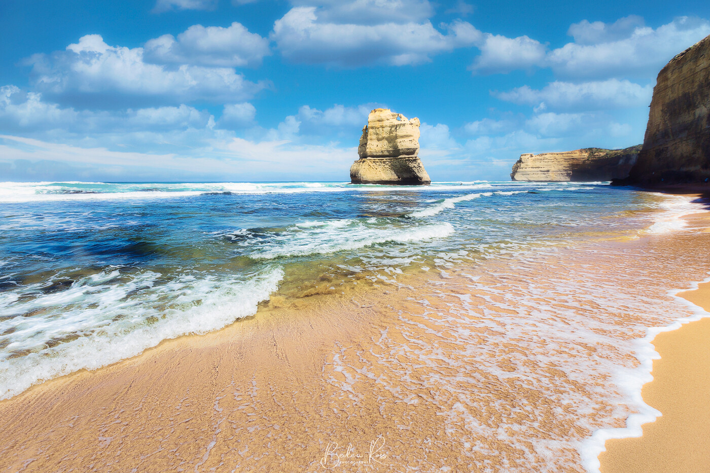
Twelve Apostles
Just one km further on is the world-famous twelve apostles. The seven towering limestone stacks rise 45-50 metres up from the ocean floor. The eighth stack collapsed in July 2005. The stacks were originally known as The Pinnacles and Sow and Piglets, with Muttonbird Island being the sow and the stacks, the piglets. So the name officially became the Twelve Apostles. However, there were never twelve stacks.


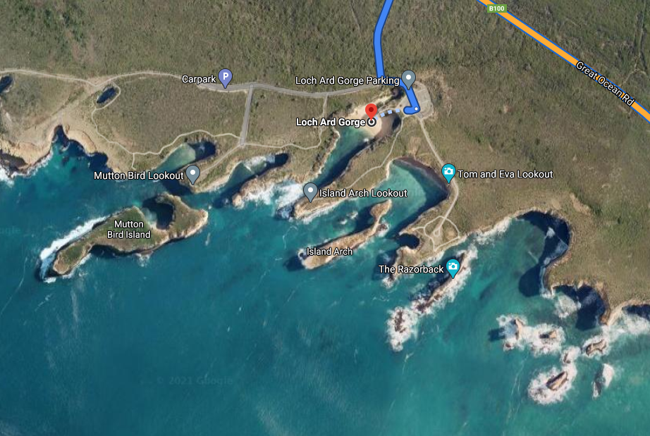
Loch Ard Gorge
Continuing, we come to the Loch Ard Gorge. Site of the most famous shipwreck along the coast.
The Loch Ard departed England on March 2nd, 1878, bound for Port Phillip Bay, Melbourne. Captained by 29yr old Captain Gibbs, it was packed to capacity with 17 passengers, 37 crew, and a cargo hold full of expensive goods.

Sinking of the Loch Ard
On June 1st, 1878, the ship sailed into dense fog, and when it lifted at 4 am they discovered they were much closer to the cliffs than they thought. The captain ordered as much sail as possible and tried to turn the ship out to sea, but the sails fell limp. Anchors were dropped but failed to hold, and despite all efforts, the ship hit a reef on Mutton Bird Island and sank in fifteen minutes.
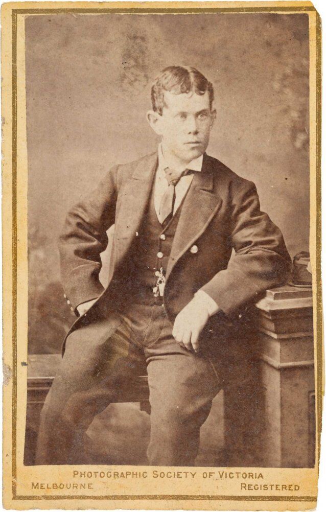

Efforts to launch lifeboats in heavy seas failed, and all crew and passengers drowned save for two. Tom Pearce, a nineteen-year-old ship’s apprentice, clung to an upturned lifeboat and made it into what is now known as the Loch Ard Gorge, where he found shelter in a cave. After five hours in the sea, Eva Carmichael, also nineteen, drifted into the gorge hanging onto a chicken coop to keep her afloat. Tom heard her cries for help and swam back out. Bringing her to safely to the beach.

They sheltered in thunder cave that night, and in the morning, Tom set off for help, climbing the cliffs of the gorge. He came across two men working the farm, and while he returned to Eva, the farmhands went back to the homestead to get help. Eva and Tom spent six weeks recovering with Hugh Gibson and his wife Lavinia at Glenample Homestead (the same Gibson from Gibson’s steps) before Eva returned to Ireland and Tom returned to the sea. In the tragedy, Eva lost her entire family, of mother, father, three sisters, and two brothers. Still, only the bodies of her younger brother and sister were recovered, and are buried in the cemetery overlooking the gorge.

Tom and Eva Lookout
The survivors have named two limestone stacks near the Island Arch and are viewable from the Tom and Eva lookout.


The Arch
Fifteen minutes past the Loch Ard Gorge is the arch. The arch would be spectacular on any other coastline, but it’s underwhelming with the competition it gets from all the other rock formations. Experts believe that with continued erosion, the arch will collapse and create a new pillar. With the viewpoint from the lookout – every image looks the same. It’s nigh on impossible to get a different or unique image of it.

London Bridge
Travelling another 15kms along the great ocean road, past Port Campbell, brings you to London Bridge. Before 1990 the bridge arch was connected to the mainland, and you could walk out onto it. In January 1990, it collapsed and stranded two tourists for three hours on the new island until they were rescued by helicopter.

The Grotto
The grotto is a beautiful rock formation that is a must see as you travel the great ocean road. This incredible, unique rock formation combines a cave, sinkhole and archway all in one. Unfortunately, eons of crashing waves and winds have caused erosion, creating a caved a sink hole in the limestone cliffs.

The grotto is a short walk along a boardwalk to the clifftop. From there, you can see the grotto arch and the stairs leading down to it. Take the stairs to the bottom, and the magical grotto opens up with its smooth rock pools and a view through the arch to the open sea. Unfortunately, there is a low wall cutting access to the pools off for safety reasons. While the wall theoretically prevents access to the pools, no one heeds it, and if you do jump the wall, be mindful that it’s easy to slip on the rocks, and they are quite sharp. Also, if the waves are crashing – you could easily get swept off the rocks.

Port Fairy
The ‘shipwreck coast’ ends at Port Fairy. Around 30 ships were wrecked in and around Port Fairy between 1836 and 1876. In addition, port Fairy is infamous for ships dragging or parting with their anchors when a southerly or southeasterly gale blows.
The Port Fairy lighthouse was built in 1859 at the tip of Griffiths Island to allow ships to locate the bay.


More info: Explore The Great Ocean Road
Looking for Victorian landscape photography locations? While the smallest state in Australia, Victoria punches above its weight for photography locations. Within its boundaries are lush rainforests, spectacular coastlines, rugged mountains, and for the street photographer – a thriving cosmopolitan city cafe culture. While there are certainly a lot more than 5 locations – these are my favourite five, in no particular order. It doesn’t matter the weather – you can always get a top shot.
1. The Great Ocean Road
Probably the most famous Victorian landscape photography locations is the Great Ocean Road. Rated one of the best cliff-hugging drives in the world the Great Ocean Road was built back in the 1930s by returned servicemen. It starts at the beautiful seaside town of Lorne and hugs the cliff along the Southern Ocean to Apollo Bay before heading inland and winding its way through rolling, green hills to Nelson. Along the way, you will find spectacular views around every corner, beautiful rainforests, epic surf locations including the world-famous Bells Beach, waterfalls, wildlife, redwood forests, and epic hikes.


2. Princes Pier, Port Melbourne
Princes Pier is a 580 metre long, historic pier in Port Melbourne that was built between 1912 – 1915. It was the major arrival port for migrants to Australia during the post-war period. Its use declined over the years and in the early 1990s, it was closed due to its poor condition. Between 1990 and 2004 fourteen fires occurred caused by squatters or vandals. The State Government announced a $14m refurbishment in 2006, restoring the first 196 metres. The remaining decking was removed and the original pylons restored. It reopened in 2007 and is now a favourite haunt of photographers and anglers.


3. Dragon Head Rock
Situated at 16th Beach, one of the Rye back beaches, Dragon Head Rock is a rock formation just off the beach and accessible at low tide. From the front, it’s just a rock, but move to the side and it takes on its distinct shape. If you are a fan of long exposure, smooth water shots – it’s a fabulous location to hone your skills.

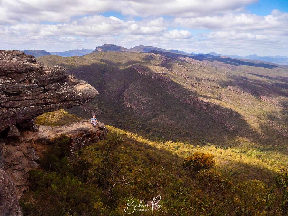
4. The Grampians
The heritage-listed Grampians, traditionally known as Gariwerd in aboriginal culture is a mountainous area close to Halls Gap and around 3 hours from Melbourne. It boasts world-famous hiking trails from gentle to challenging, waterfalls, wildlife and mountain panoramas.


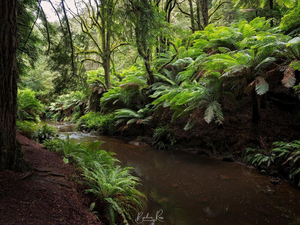
5.Warburton
Warburton could be Melbourne’s best-kept secret. While it’s well known to Melbournites it rarely features on any list for tourism. Its set among the hills of the beautiful Yarra Valley and is an easy 90-minute drive from Melbourne. Down by cement creek you will find the Californian Redwood forest. Thousands of towering Redwoods set in rows with a carpet of leaf litter and dotted with mysterious forest art, and a fern gully along the creek at the back make it a magical place. Not far from the Redwood Forest is the Rainforest Gallery – a stunning, easy walk through the forest over bridges above the forest floor and down along streams with tumbling cascades.


Well, there you go, my favourite five, which is not to say there isn’t loads more epic locations. What are your favourite locations in Victoria? love to hear your thoughts.

We were taking the visiting Scottish cousins away for three days to the Grampians and chose the Northern Grampians. Why the Northern Grampians and not southern, western, eastern, because not only for the abundance of wildlife, but they have most of, the iconic natural attractions found in the Grampians. Boroka Lookout, Reids Lookout, The Balconies, Mackenzie Falls and The Pinnacle can all be found a short drive from Halls Gap, a comfortable 3 hr drive from Melbourne.
We had visited the Northern Grampians in 2016 again basing ourselves in Halls gap. This time around we booked into Halls Gap Log Cabins, nice two bedroom cabin, and very comfy and handy to everything.
Wildlife at Northern Grampians
Every day as the sun went down the ‘roo’s came into the grounds. The owners, as a result, never need to mow their lawn here 😉


Another frequent visitor in the late afternoon were the emu’s. They turned up like clockwork every afternoon around 5pm in the large open paddock behind the cabins, wandering around foraging, only slightly interested in mad tourists.
We made the mistake, on the the first day of feeding a magpie…. I know, I know, I can hear you shaking your head. Within minutes we had a host of cockies joining the maggies.. and they ended up getting the lions share of the twisties!

Due to seeing a sign next morning, ‘please dont feed the birds’ we hung our heads and shame and refused to feed them next afternoon when they came calling.
Country Roads
We headed out next morning with plans to visit Boroka Lookout, Mackenzie Falls and Reids Lookout… unfortunately Google Maps on my phone directed us down a poorly signposted dirt road for about 30kms, then told us in the middle of nowhere “you have arrived”. By now, we also had no phone service so we kept following the road for about another 20kms. We came to a sign saying Halls Gap, and took it. Continued on the dirt road, for a few more kms, then came to a fork in the road, with no idea which way to head. Asses Ears Road or Rosebrook-Glenisla Road? Neither sounded a good idea.
Wondering which road to take, and with visions of search and rescue finding our bleached bones in 30 yrs time, I suddenly realised that right at this spot, I had four bars of service! Plugged in Halls Gap and off went again. Back the way we had come. Just a few yards down the road service dropped to one bar then none, but by now, I had the maps loaded. We eventually came back out at Northern Grampians road with a signpost to the lookouts and falls. Cue the applause in the car. We had just done a needless, 50km plus dirt road detour.

On the upside, we saw loads of wildlife, and while they moved way too fast to photograph, or get near, we did spots lots ‘in the wild’. From Kangaroo’s, Wallaby, Emu’s even a deer or two on these rarely travelled (by smart people) tracks.

Back on solid, man made roads we hot footed straight to Mackenzie Falls. Having absolutely no intention of going to the bottom of the falls, we took a couple of walks to view Broken Falls and Mackenzie Falls from the top.
Mackenzie Falls


Boroka Lookout
Leaving Mackenzie Falls behind we drove to Boroka Lookout.

Where both the MOTH and a visiting Scottish cousin ducked through the railing for a photo op


The rest of the day was taken up with non photographic but enjoyable stuff like eating, drinking, watching clouds go by….
Next Morning……..

Waking up next morning, we found the sun had gone.. .light misty rain was coming across the hills. We decided instead to visit Dunkeld in the Northern Grampians sector. Not the best idea. Rain pelted down as we were leaving the and the mountains had heavy cloud hanging over them

Arriving in Dunkeld we headed to the Arboretum. Maintenance was being done on the pier I wanted to shoot and it was completely blocked by fences and workmen. Plan B, we’ll go to the museum in the old railway station. Closed. Only open sundays and public holidays. After 1pm. **heavy sigh** Plan C – lets go to the bakery.

Set back off the main road in a suburban street the bakery is obviously well known as on a wet tuesday it was still busy. The carrot cake and coffee were delicious. No photo. Ate it too quick 😉
The Balconies
Leaving the town that was almost awake we drove back towards Halls Gap. By now the weather was improving so we decided to go to The Balconies on the way back. They are at the same carpark as Reids Lookout, but it had been too warm to do the uphill walk the day before.
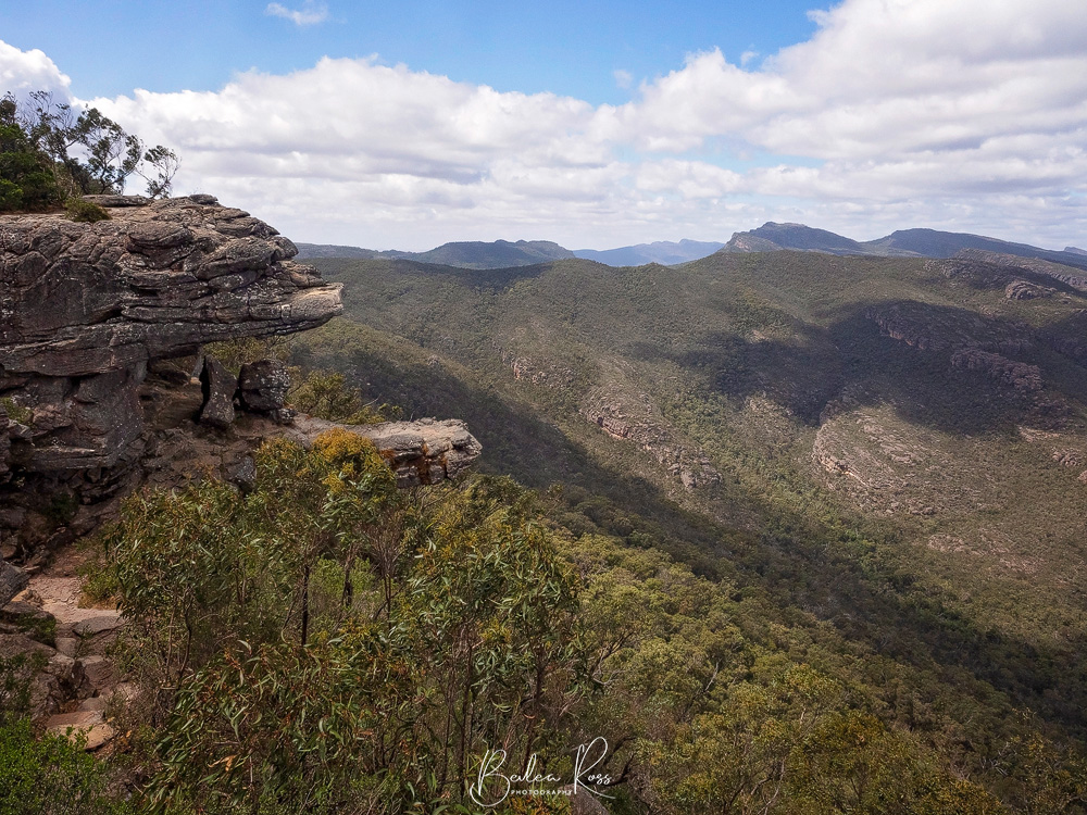
The walk is supposed to be ‘easy’ as its only 1km each way. “Suitable for all ages and fitness”. According the to brochures its a ‘slight incline’. We, however, made use of the chairs on the way up and arrived sounding like asthmatic steam trains. Obviously our level of fitness is considered extinct and not worth mentioning.

This time I didn’t need to encourage the MOTH to climb the barrier and go out on the balcony. Not that I would have suggested it this time – it was blowing a gale up there. But an unknown man who “has done it heaps of times its quite safe” went out there for a friend and we snapped his pic as well.

Next day we headed back home to Melbourne…. had a lovely three nights there with Scottish girls. I thoroughly recommend the Halls Gap Log Cabins. Comfy stay and wildlife at your door, (and the shower was awesome)
With a gorgeous day forecast for Sunday, we took a drive up to Tahbilk Winery at Nagambie before going to the Pink Cliffs at Heathcote. Along the way, we found and stopped for Canola fields bordered by Wattle shrubs and Gum trees.


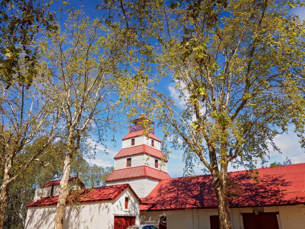
Established in 1860 Tahbilk is the most beautiful and historic family owned winery in Australia, located in one of the nation’s premium viticultural areas. The property itself comprises some 1,214 hectares of rich river flats with a frontage of 11 kms to the Goulburn River and 8 kms of permanent backwaters and creeks.
Tahbilk Winery
The Winery
Tahbilk is a lovely old winery, established in 1860 and bordered on two sides by the Tahbilk Lagoon and Goulburn river. The cellar door is open seven days a week, and the very popular cafe is definitely one you need to book for. Its been in the Purbrick family since 1925, with five generations of the family at the helm.
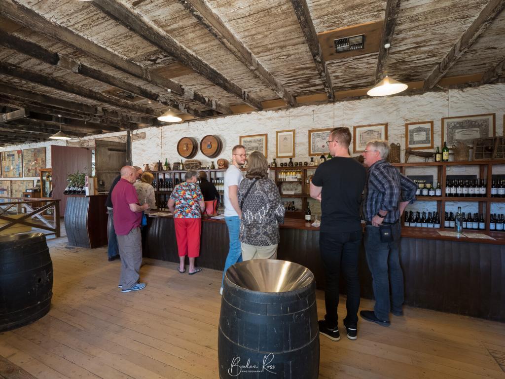
We tried the Sauvignon Blanc and Verdelho.. and liberated a bottle of the Verdelho to bring home with us.

Downstairs from the cellar is the old, old cellars still in use. They’ve been there since 1867. The floor is worn in front of the barrels. You wonder how many people have worked there over the last 151 years


Leaving Tahbilk winery, we drove to Mitchelton winery. However, they had a large wedding with people and cars everywhere, so we moved on and stopped at Nagambie lakes for lunch before heading to Heathcote and the Pink Cliffs.
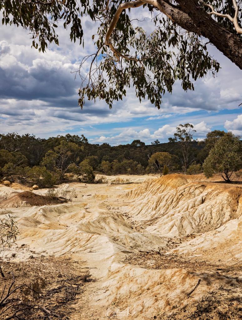

Pink Cliffs
I found the cliffs VERY underwhelming. They are a series of small, sandy white and reddish rocks and mounds, with a few boulders and lots of gravel and sand. I did do one HDR, which turned out ok. But overall, they are not a place I would bother returning to, and ‘pink’ is drawing a very longbow.

Update
It turned out we were in the wrong place. We were only on the outer, smaller edge of the pink cliffs. I found the area everyone was raving about – and it was fabulous.

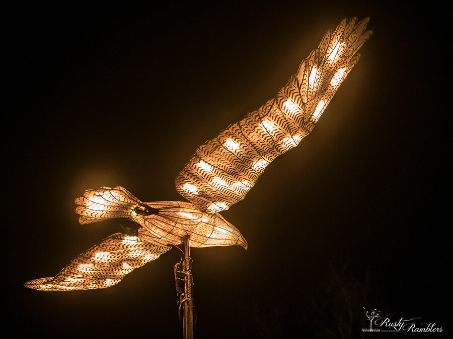
White Night Bendigo was inspired by the international Nuit Blache movement that began in Paris in 2002 and has spread to 20 cities worldwide. In 2013 Melbourne held its debut white night, where the city was reimagined through art, music, colour and light. Ballarat hosted its first White Night in 2017, and Bendigo followed in 2018, with Geelong also holding its first White Night later this year on October 13.
Shamrock Hotel

We drove up to Bendigo on Saturday morning and booked into our Accom. Our hotel was the Shamrock in the heart of town and the centre of most of the displays. The hotel itself was great, and the beds were comfy, the shower was fantastic, and the location was stellar. We were just a short walk to Queens Park and View Street across the road from the GPO and Rosalind Park.
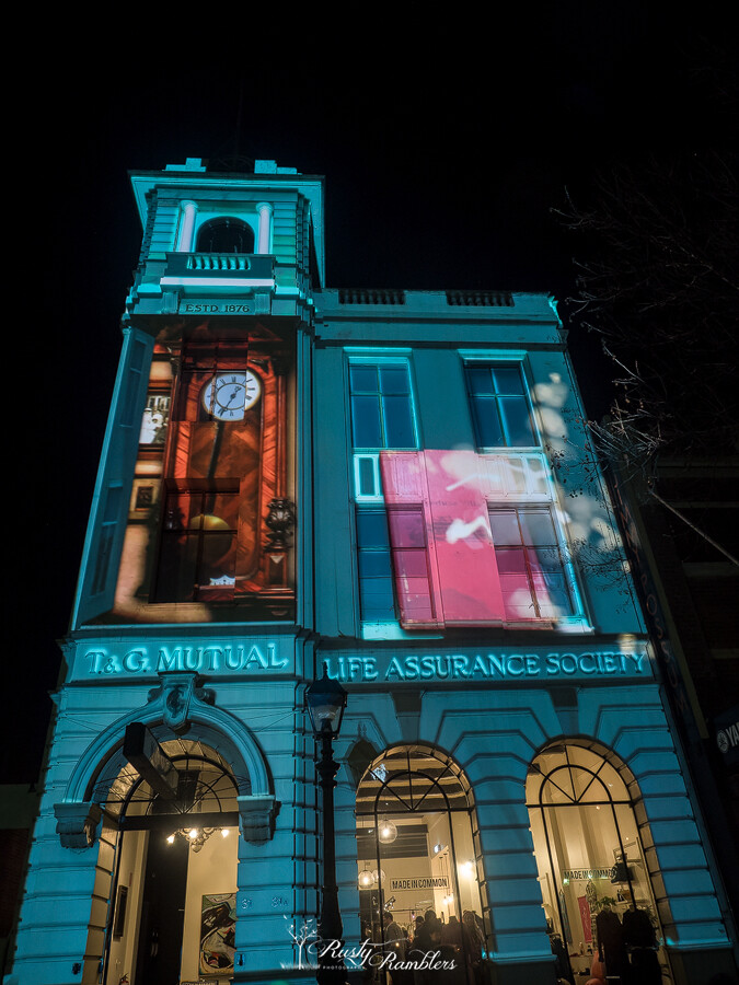


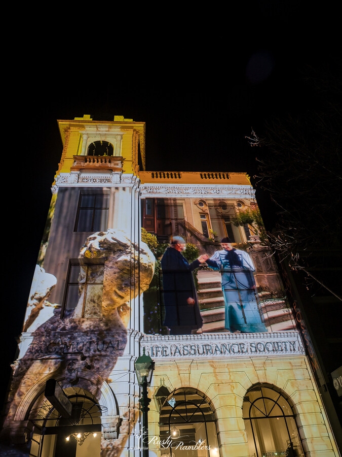
The Old GPO scrolled from 1920 to 2000 with popular/famous film and TV stars.
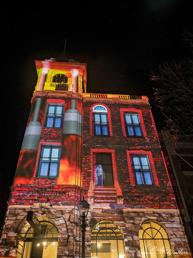
The standout of the night for us was the Returned Soldiers Memorial telling the story of Australia from around 1900 to 1918 and marks the 100th anniversary of the end of WWI coming up this November.


Further up, we found the ‘Fortuna Villa’ story
The infamous ghost book of Fortuna Villa has been found and has come to life! It’s fallen off the shelf and hit the floor with the pages open, releasing the spirits and memories recorded in its pages by the poor army watchmen for decades.
https://whitenight.com.au/bendigo/program/the-fortuna-villa-story/


Over five metres high and with wings that span six metres, the Messenger is an awe-inspiring, futuristic archangel that transcends nationality and religion to spread its message of love and compassion.

White Night Bendigo was a fantastic event. According to official figures, 60,000 people enjoyed the night. Every hotel and motel was booked out, and most restaurants too. Hopefully, it will run again in Bendigo next year. We’ll definitely go if it does!

“The introduction of a few rabbits could do little harm and might provide a touch of home,” Thomas Austin
Rabbits!
Thomas’s fondness for rabbit hunting led to rabbits in plague proportions across Australia and the building of the Rabbit-Proof Fence across Western Australia between 1901 and 1907 to stop the spread of rabbits into the state from the eastern states. Thomas was a member of the Acclimatization Society of Victoria. The society introduced non-native animals and plants to the growing colony – as a member, Thomas also brought in blackbirds and partridges. Thomas Austin and his wife Elizabeth built the lavish 42-room mansion in 1871. He died just six months after it was completed, but Elizabeth lived at Barwon Park until her death in 1910 and became a noted philanthropist. One of her biggest accomplishments was funding the Hospital for Incurables (later the Austin Hospital) in Heidelberg.
National Trust
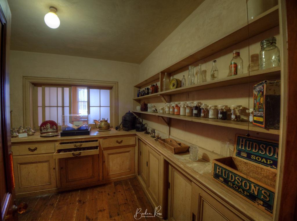
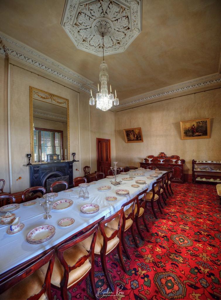
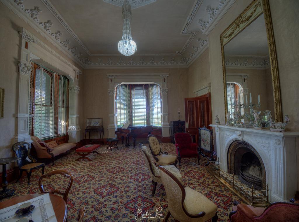
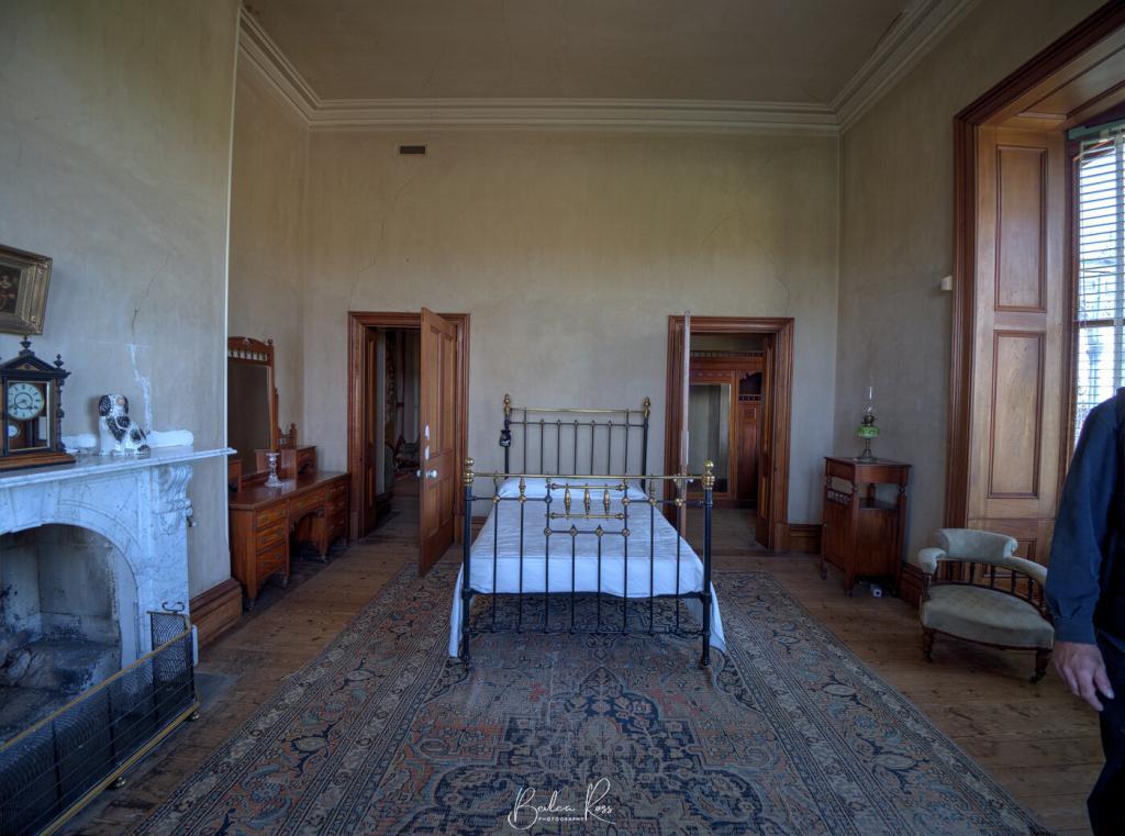
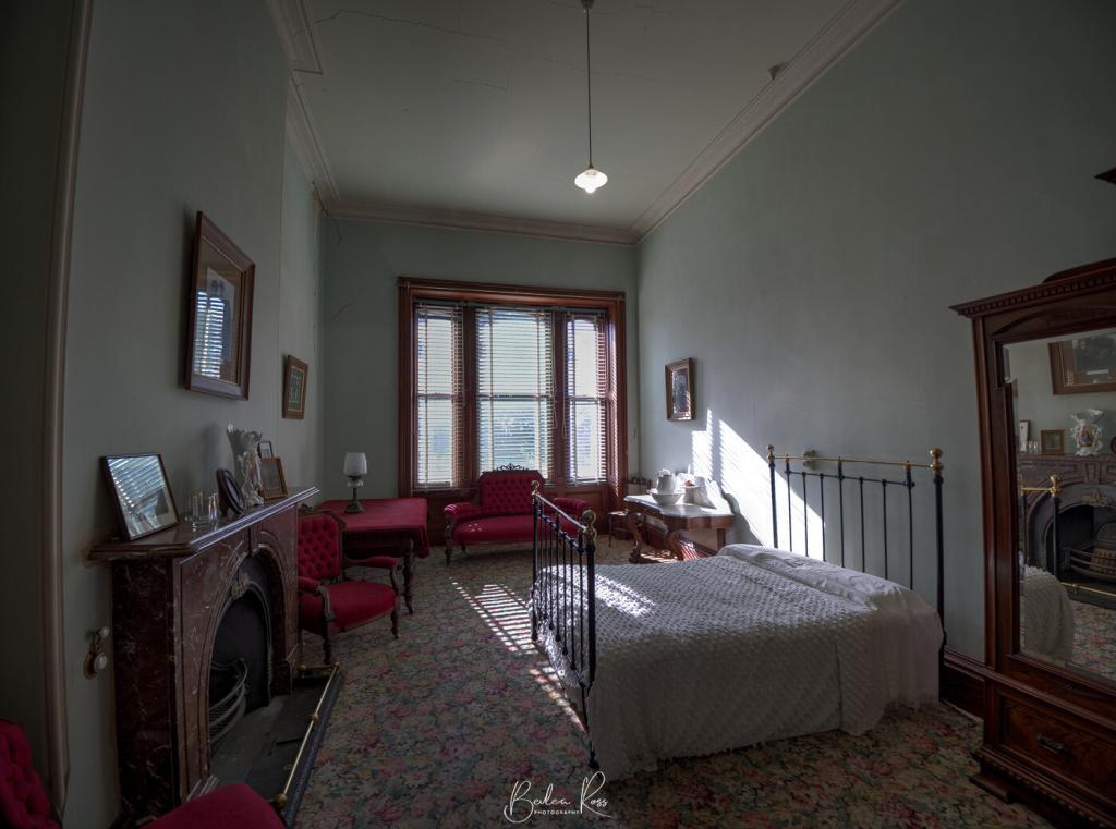
In 1912 the house was sold Batson family, who later bequeathed it to the National Trust. At the time of the bequest, while the house was still virtually an intact relic, it had fallen into serious disrepair, and much of the furniture, artworks, and silverware had been sold off to provide an income for the two sisters and one brother left in the house. The National Trust has since repaired the mansion and fitted it out with furniture that had been part of the house – or of the time.
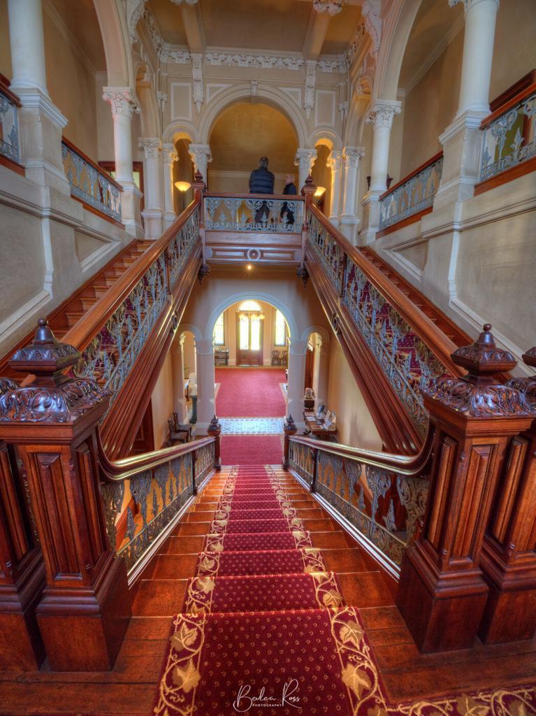
The Grand Staircase
The staircase was the first of its kind in Australia – being that it led directly up the centre of the hall and then branched left and right… rather than being on the side of the hall, as was the norm. And while it does look exactly like the one at Werribee Mansion – it was built three years prior to Werribee Mansion. Thus, it was the Austins to introduce the style to Australia. It was also built which much wider steps than normal to allow the ladies to descend the staircase gracefully and make a ‘grand entrance.