Victoria’s Great Alpine Way

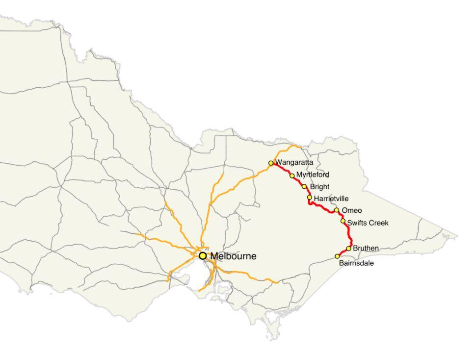
Victoria’s Great Alpine Way is one of the most scenic drives in the world and belongs on everyone’s bucket list. It is 304km long and starts in Wangaratta. The road travels through Myrtleford and Bright before winding its way up and through the Victorian Alps before terminating at Metung in Bairnsdale. It passes through mountains, valleys, forests, rivers, farms and vineyards. Like its coastal cousin, The Great Ocean Road, it hugs cliffs and clings to ridges providing spectacular views at every turn. The Great Alpine Way is Victoria’s highest sealed, year round, accessible road.
History
The Bright to Omeo section was upgraded in 1883 from packhorse to a wide road to allow horse-drawn coaches. It carried goods and people to the Ovens Valley, Omeo, Cobungra and goldfields. The route was a combination of the Ovens Highway and the Alpine Road and was renamed the Great Alpine Way when the final section was sealed in 1998. It’s a drive that requires respect. The Harrietville to Mount Hotham section is particularly steep, with a few extreme hairpin bends with sheer drop-offs requiring extra care in that section.

As it passes over Mount Hotham, the road has an altitude of 1,840 metres, carpeting it with snow in winter. Snowploughs clear the road daily. Extreme conditions still see the road closed from time to time. Take the road slow. It will be safer and allow you to enjoy the spectacular scenery.

Which Direction?
Which is the best way to do it? Southeast from Wangaratta to Bairnsdale or northwest from Bairnsdale to Wangaratta? The main factor in your decision is the sun. Between April and September, the sun is lower in the sky and taking the bends or going over crests will be more problematic if not downright nerve-wracking driving into the sun. Driving late morning/early afternoon Wangaratta to Bairnsdale is the best option as the sun will be behind you. The views and photography are much better if not shooting or squinting into the sun. If you are travelling early morning – then Bairnsdale to Wangaratta is better.


Mount Hotham
Mount Hotham, named after Charles Hotham, Governor of Victoria from 1854 to 1855, is Australia’s highest alpine village. With its short, cool summers and long, freezing winters, Mount Hotham’s climate is Subantarctic.


Planning on a few days to do it? NRMA has a great itinerary
Wallaces Hut

As you drive through Falls Creek, keep your eye out for Wallace’s Hut. Park in the Wallace’s Hut parking area and walk 750m down the path to the hut. The three Wallace brothers built the oldest surviving cattlemen’s hut in the Victorian Alps was built in 1889 by the three Wallace brothers. The family had a large ‘run’ at Kergunyah near Beechworth and grazing land on the banks of the Kiewa River. As was the custom, they took the cattle up the mountain to fatten the herd over spring and summer, allowing the home pastures to recover from the Winter.

Bogong High Plains
In 1889 the three brothers took a herd up to the Bogong High Plains. While there, they decided to build a hut to shelter from the extreme mountain weather. They searched for a site sheltered from winds. But one was close enough to water and firewood before choosing a site nestled among snow gums with a rocky outcrop at the back. They constructed the hut from snow gums and used straight mountain ash as roof shingles. The roof pitched at a steep angle to ensure snow wouldn’t settle heavily on it. Finished in six weeks, it measures just 6.3 mt x 3.5mt.
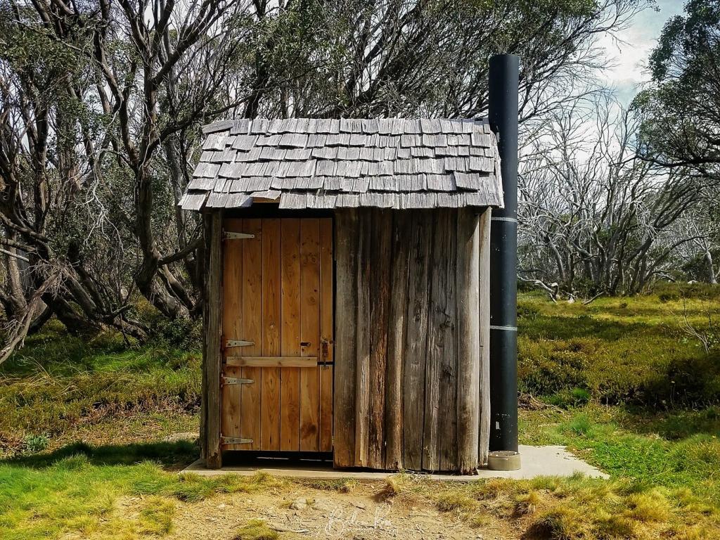
Wallace’s hut is now classified by the National Trust, owned by Victoria, and managed by Parks Victoria.

