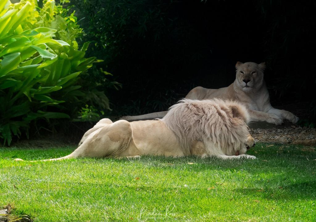
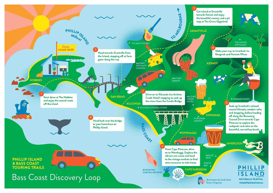
Tag:victoria

Nestled amidst the bustling inner suburbs of Melbourne, Ripponlea Estate offers a captivating glimpse into Victoria’s grand colonial past. Step back in time and explore the meticulously preserved Ripponlea Mansion, a magnificent example of Italianate architecture that whispers tales of affluence, societal change, and the enduring legacy of the wealthy Clarke family. As you wander through the ornately decorated rooms, marvel at the opulent furnishings, and lose yourself in the meticulously landscaped gardens, you are transported to a bygone era of elegance and grandeur.
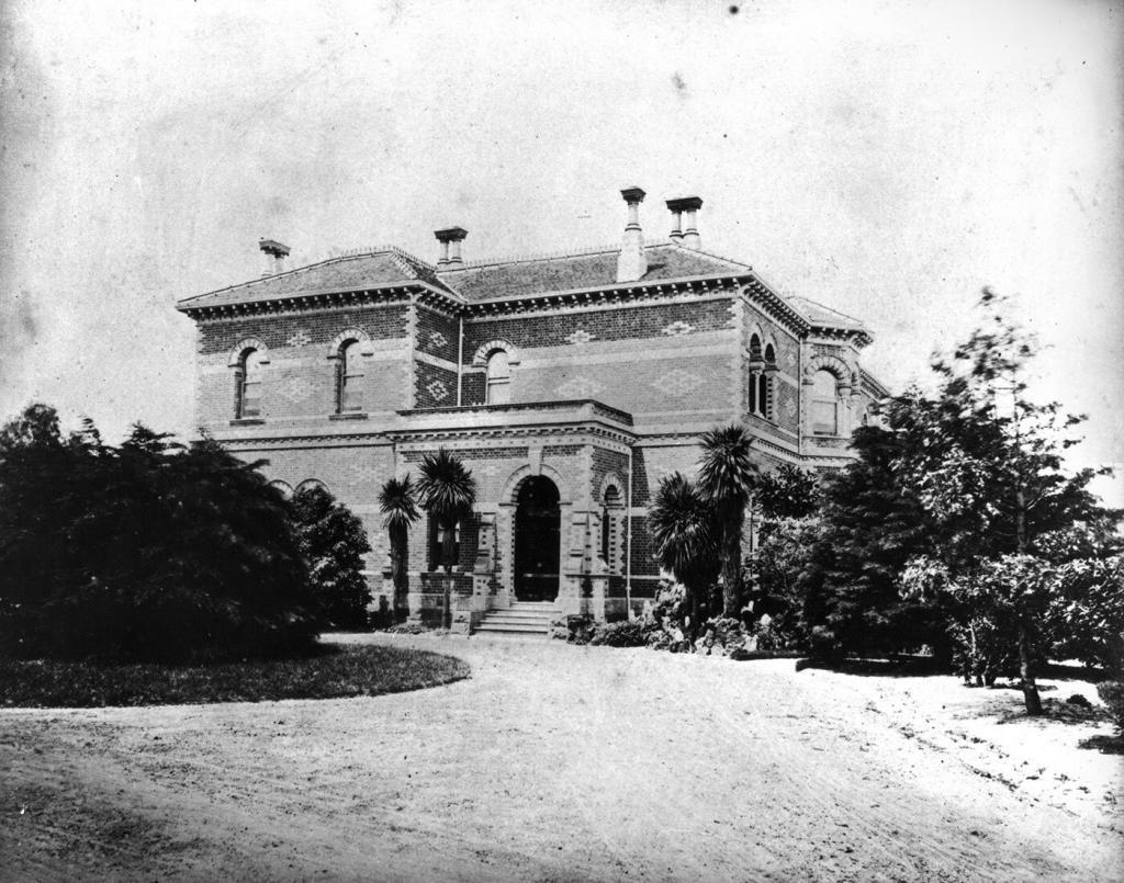
Ripponlea Estate is a historic site in the heart of Melbourne, well known for its cultural heritage and stunning architecture. It features a grand mansion, lush gardens, and a rich history, making it an iconic landmark. The estate dates back to the 19th century when it was established by Sir Frederick Sargood, a well-known businessman and philanthropist from Melbourne.
The Mansion
In 1868, Sir Sargood purchased the land. Architect Joseph Reed was commissioned to design a luxurious fifteen-room mansion that would become the focal point of the estate. The Victorian Italianate mansion, similar in style to Werribee Mansion, was a stunningly beautiful architectural masterpiece. It featured intricate details, a grand staircase, luxurious interiors, an underground watering system, and even its own electricity supply. It was rare for that period to have indoor bathrooms, but Ripponlea had them, adding to its reputation as a symbol of luxury and sophistication.

During the 1880s, the mansion underwent significant renovations. The dining room was enlarged to the size it is today. In addition, a tower was constructed, and a second floor was added to the back wing of the mansion. The kitchens were also remodelled, and a larger fernery was planted. A veranda was fitted on the west front, and the gardens were redesigned. Furthermore, the drainage system was extended to improve the overall functionality of the mansion.

In 1897, the mansion underwent further renovations. These included the addition of the current front entrance, a gentleman’s washroom, and an office. The study was extended to become the drawing room, while the former drawing room was transformed into an informal sitting room. The staircase was rebuilt, and the mansion was expanded from six to eleven bedrooms, some intended for staff. Additionally, a large new bathroom was added upstairs.
The Sargood Family
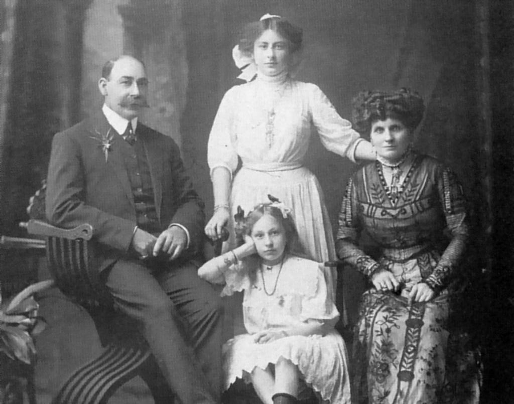
Upon completing Ripponlea, Sir Sargood, his first wife Marian, and their nine surviving children moved into the mansion. They were accompanied by an entourage of staff, which included seven maids, a butler, seven gardeners, a coachman, and a groom. In 1878, Marian Sargood passed away while giving birth to her twelfth child (a stillborn boy) on her fortieth birthday. Following her death, Sargood took his children and three staff members back to England. However, in 1882, he returned to the mansion with a new wife and another child, a daughter born the day before the ship docked. After his return, he continued with his career as a member of parliament and was later appointed as the Minister of Defence.

In 1901, Sargood was elected to the first Australian Senate. Unfortunately, during a trip to New Zealand in 1903, he fell ill suddenly and passed away. After his death, Lady Sargood sold the property for 20,000 pounds. She then left for England with her daughter, never to return.
New Owners
In 1903, a syndicate led by Thomas Bent acquired Ripponlea from Lady Sargood. Bent, who later became the Premier of Victoria in 1904, used the property for hosting charity events and entertaining guests. However, he also started selling parts of the land. Bent was forced to resign in 1908 due to suspicion of corruption. He passed away the following year during an investigation into his alleged connection to land scandals. His death prevented Ripponlea from being further divided.

In 1903, Benjamin Nathan, a successful businessman, bought the estate. Nathan had made his fortune in the furniture business as the Maples Furniture and Maples Music owner. He moved into the property with his wife and two daughters and introduced more native plants to the garden. He also added a conservatory and 14 glass houses to grow orchids and employed 14-17 gardeners to maintain the garden. After Nathan died in 1935, his daughter Louise inherited the property.
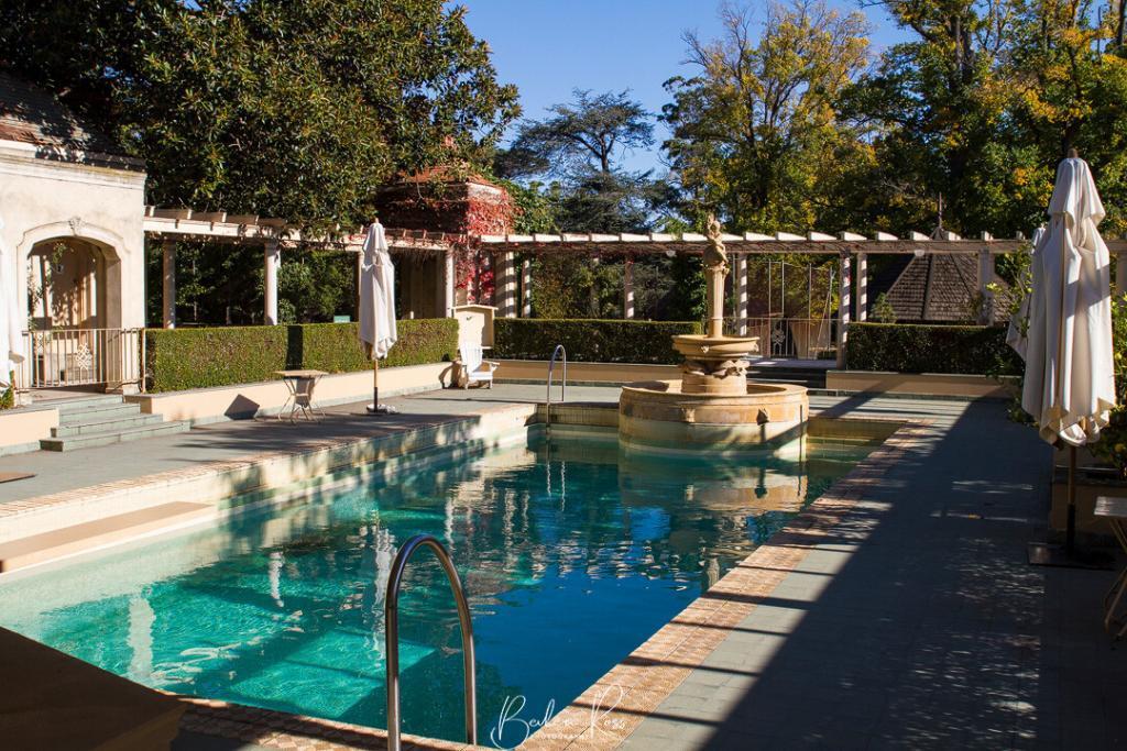
Louise, her husband, lawyer Timothy Jones, and their four children moved into the property and started renovating it. They added a new kitchen and remodelled the dining room. The original ballroom was removed and replaced with a swimming pool, while the billiard room and museum were converted into the new ballroom. The house was cleared of clutter and redecorated in an elegant neo-baroque style featuring mirrors and soft greens.


Saving Ripponlea
In the early 1950s, Louise sold some of her land to ABC, who wanted to build a television studio. However, in 1963, ABC wanted to expand the studio. Subsequently, the federal government issued a compulsory acquisition order for an additional four acres of Louise’s land. She fought the order in the high court but unfortunately lost. A demonstration against the acquisition attracted 10,000 people. Louise knew her father wanted the gardens protected, so she arranged for the property to be transferred to the National Trust upon her death.

In 1972, Louise passed away, and the National Trust inherited Ripponlea. As a result, the acquisition order was withdrawn. Ripponlea was opened to the public for the first time in 1974. Within the first three months, it was visited by one hundred thousand people. Recognising its historical and cultural importance, the National Trust of Australia officially classified Ripponlea as a heritage-listed property in 1979. This designation ensured that the estate would be preserved and maintained for the benefit of future generations.
Today
Ripponlea Estate is a public attraction that allows visitors to travel back in time as they explore the mansion, gardens, and surrounding grounds. Guided tours are available, providing valuable insights into the lives of the estate’s former residents and the historical events that took place there. In addition to being a popular tourist destination, the estate is also a venue for events, weddings, and cultural programs. It is also frequently used as a film location, making it a vibrant part of contemporary Melbourne.
Visiting
192 Hotham Street, Elsternwick 3185 VIC
Entry Fees: General Admission includes garden entry plus a guided tour of the mansion (subject to availability).
Adult: $15
Concession: $12
Child (3-15 years): $9
Family (2 adults + 2 children): $40.
National Trust Members FREE.
Residents of the City of Glen Eira and Port Phillip have free access to the gardens at Rippon Lea Estate.
To obtain an entry card, residents must show acceptable forms of ID with proof of residency and complete an application form available in the Gatehouse on entry to the property.

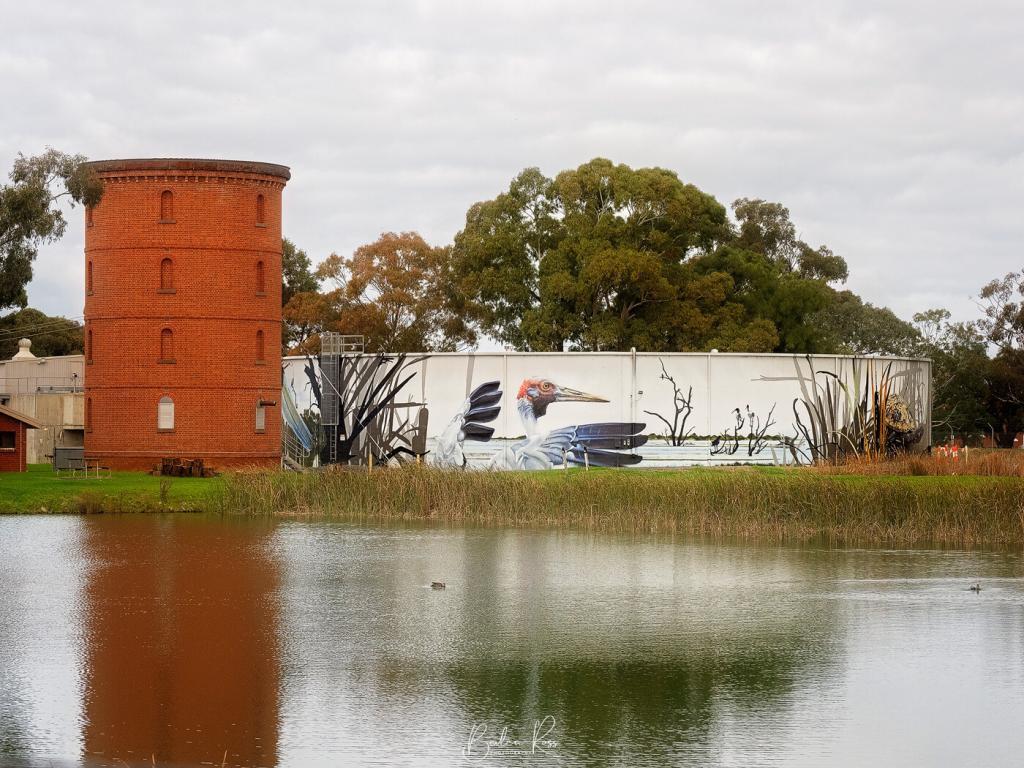
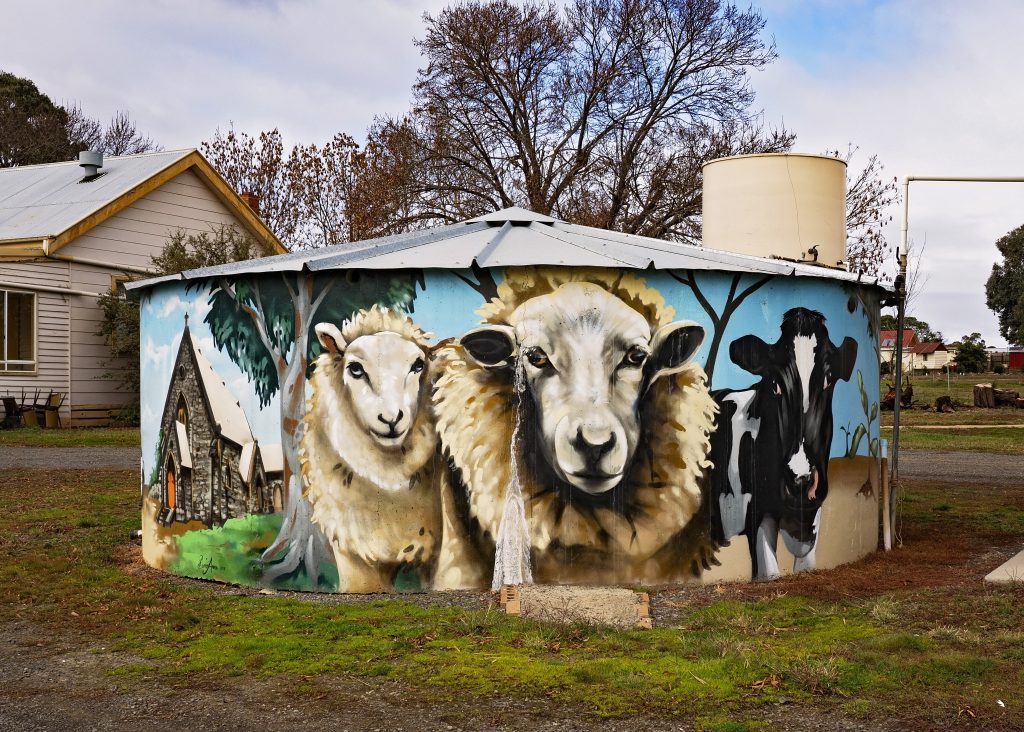
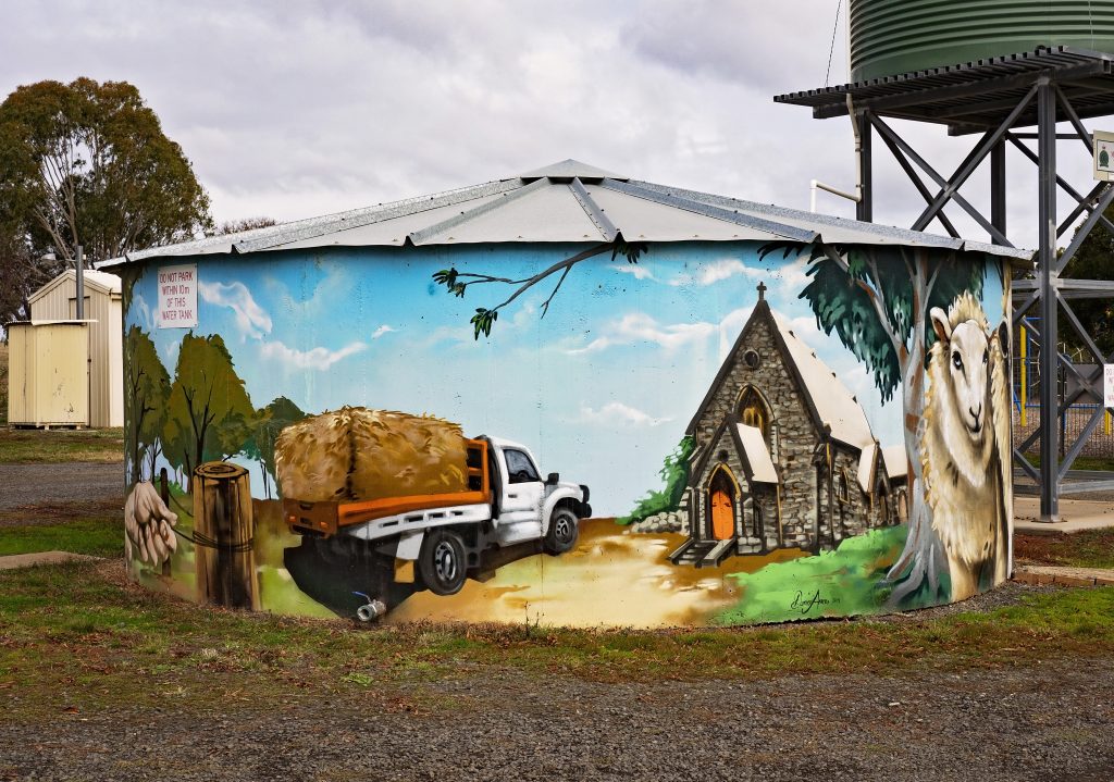
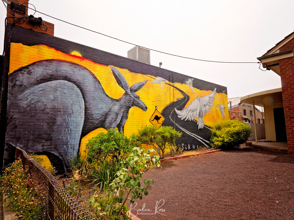
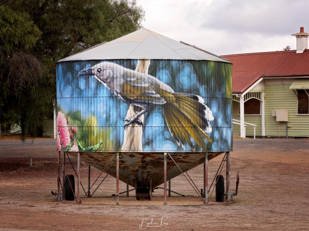
Victoria, a beautiful state in Australia, is famous for its natural beauty, cultural heritage, and lively art scene. In this captivating landscape, the painted water tanks have become an unexpected canvas that has captured the attention of locals and visitors, primarily due to the popularity of painted silos. Once considered mundane, these structures have been transformed into stunning works of art, creating open-air galleries that enhance the rural and urban landscapes.
The Artistic Transformation
In recent years, people in Victoria have been encouraging local artists to collaborate with communities to transform ordinary water tanks into captivating works of art. Street artists and more traditional muralists have joined forces to create visually stunning pieces on these cylindrical canvases. The designs typically reflect the local culture, history, and environment. Each painted water tank tells a unique story, from depictions of native wildlife and plant life to indigenous artwork honouring the land’s original caretakers to contemporary designs that celebrate city life.
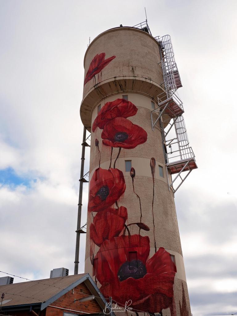
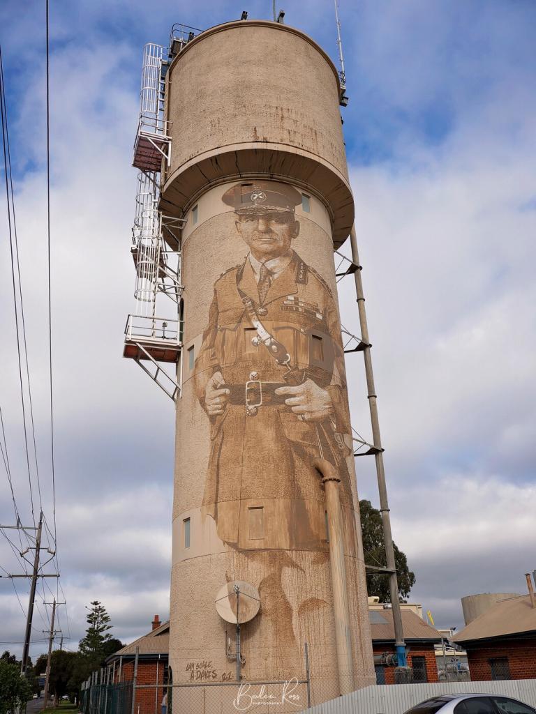
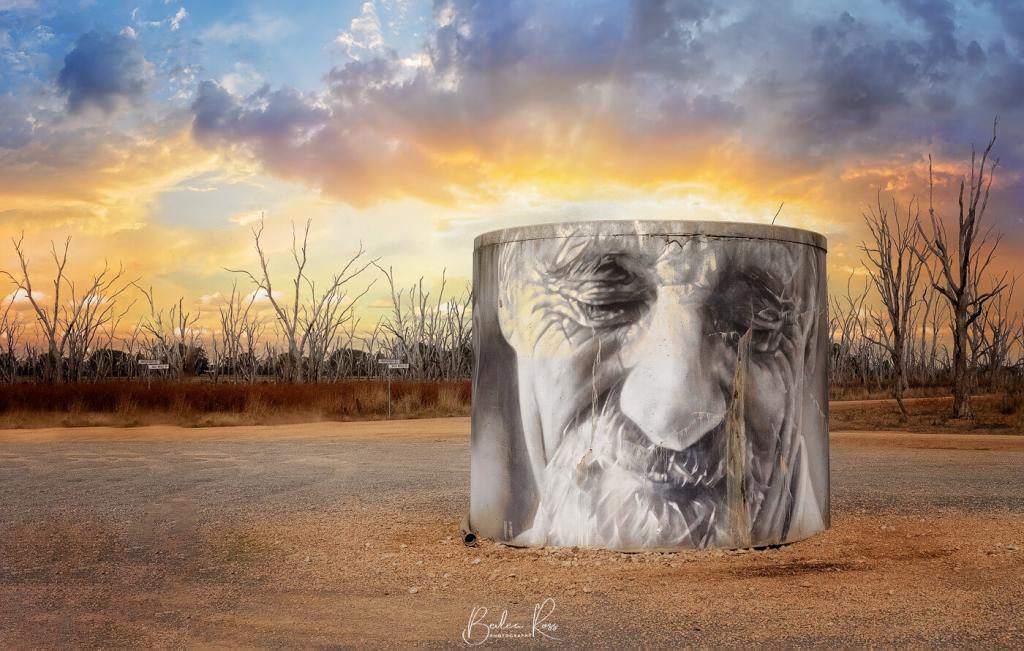
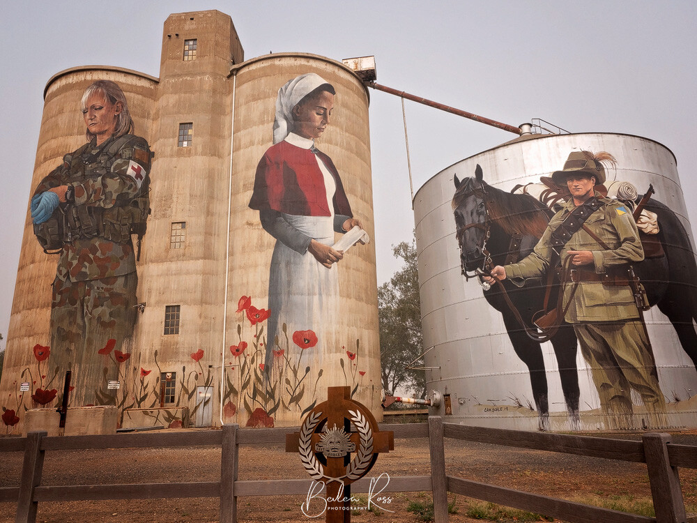
The Tatura water tower has remembrance poppies on one side and a portrait of Sir John Monash on the other. Cam Scale and Andrew Davis are the talented artists who created this beautiful artwork on the tower. The tower was built in 1912 and was designed by Monash, who was not only an engineer but also a renowned Australian military commander during WWI. The Tatura Water Tower is also the earliest surviving example of a reinforced concrete tower of its type in Victoria.
Connecting with Communities
The painted water tanks are beautiful not only because of how they look but also because of the sense of community they create. Making these artworks involves working with the locals, who help choose the themes and colours and even share stories to inspire the artists. This collaboration helps strengthen the community’s pride and ownership, transforming the water tanks from ignored structures into cherished symbols of identity.
Promoting Tourism
The painted water tanks have made quite a name for themselves, attracting tourists who crave a unique artistic experience. People now venture beyond the usual tourist spots to discover the hidden treasures of Victoria’s countryside and towns. The tanks have undeniably boosted tourism, increasing local economic revenue.
Challenges and Future Prospects
Painted water tanks have received much positive attention, but some difficulties come with this movement. Obtaining funding for significant projects and acquiring the necessary permits can prove challenging. Moreover, certain heritage-listed water tanks are not permitted to be altered. Additionally, artists must deal with logistical issues such as working at heights and ensuring the artwork can withstand weathering.
Despite these obstacles, the outlook for Victoria’s painted water tanks is bright. As the movement gains popularity, more potential sponsors and supporters are expressing their interest. The state’s commitment to promoting arts and culture further solidifies the importance of these water tank masterpieces as a crucial part of Victoria’s artistic heritage.
The painted water tanks in Victoria showcase the remarkable impact of art in elevating ordinary structures into extraordinary works of art. These structures, which were once ignored, have now become vibrant symbols of artistic expression, environmental awareness, and community collaboration.
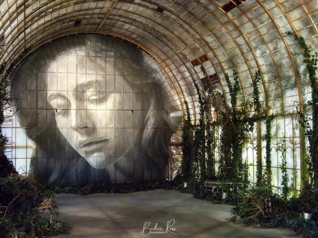
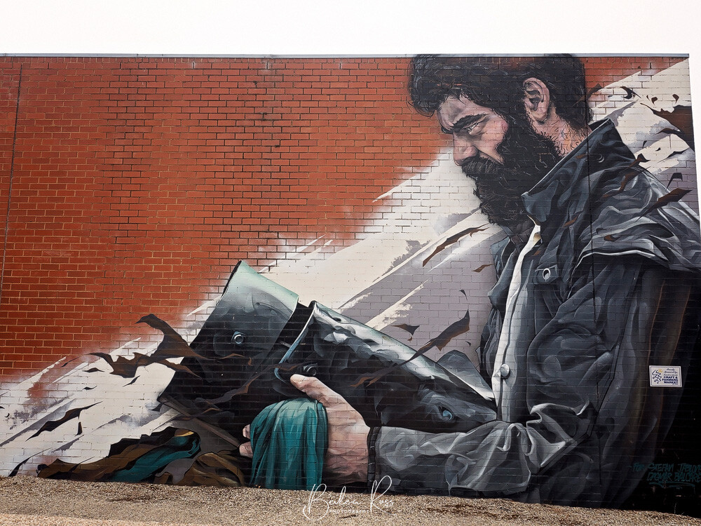
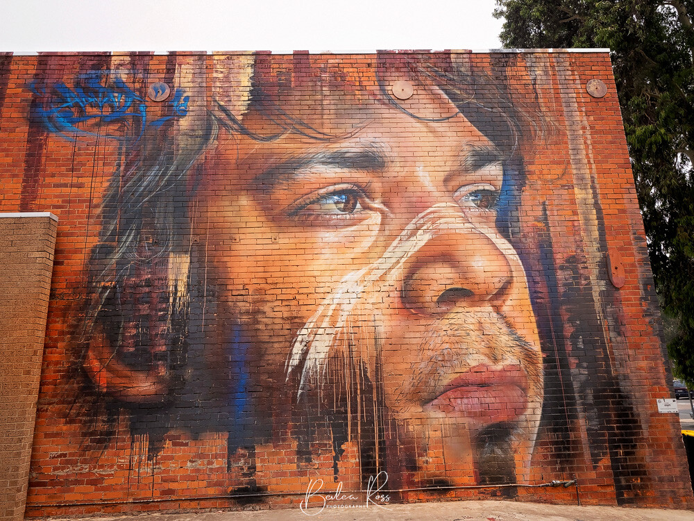
Victoria’s street art scene is a lively showcase of creativity and self-expression. Urban walls have been transformed into stunning works of art, making it a highly respected art form. Street art constantly evolves, capturing the essence of culture, identity, and social commentary. Artists are continually creating new pieces, and new art may replace or cover older ones.
The Evolution of Street Art in Victoria
Victoria’s street Art had humble beginnings as an act of rebellion; however, it has transitioned into a legitimate art form.
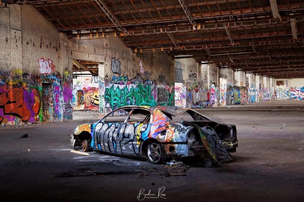
Victoria’s street art scene emerged during the 1970s and 1980s, with graffiti artists leaving their marks on public spaces. Initially regarded as vandalism, attitudes changed in the 1990s as artists created more complex and imaginative works. Debates arose about how to distinguish between art and vandalism.

Street art festivals in Victoria during the early 2000s provided legal spaces for artists to express themselves through murals and graffiti. Notable events like the Stencil Festival and Melbourne International Street Art Festival were crucial in legitimising street art as a recognised art form. As street art gained acceptance, many councils and property owners commissioned artists for larger, socially significant murals celebrating local culture and history.
Art and Artworks
As street art gained popularity and commercial appeal, more and more artists entered the traditional art world. For example, exhibitions like Rone’s Time or Empire have showcased his creative skill, earning recognition from collectors and enthusiasts alike. This blending of street and traditional art highlights the incredible talent and versatility of Victoria’s street art scene.
Street Art with a Purpose
Street art has become a crucial part of urban development in recent years. It revitalises and activates urban areas, beautifies spaces, and promotes a sense of community. Victoria encourages street art, which increasingly incorporates cultural and social commentary. Artists use their work to raise awareness about important societal issues and engage the public in meaningful discussions.
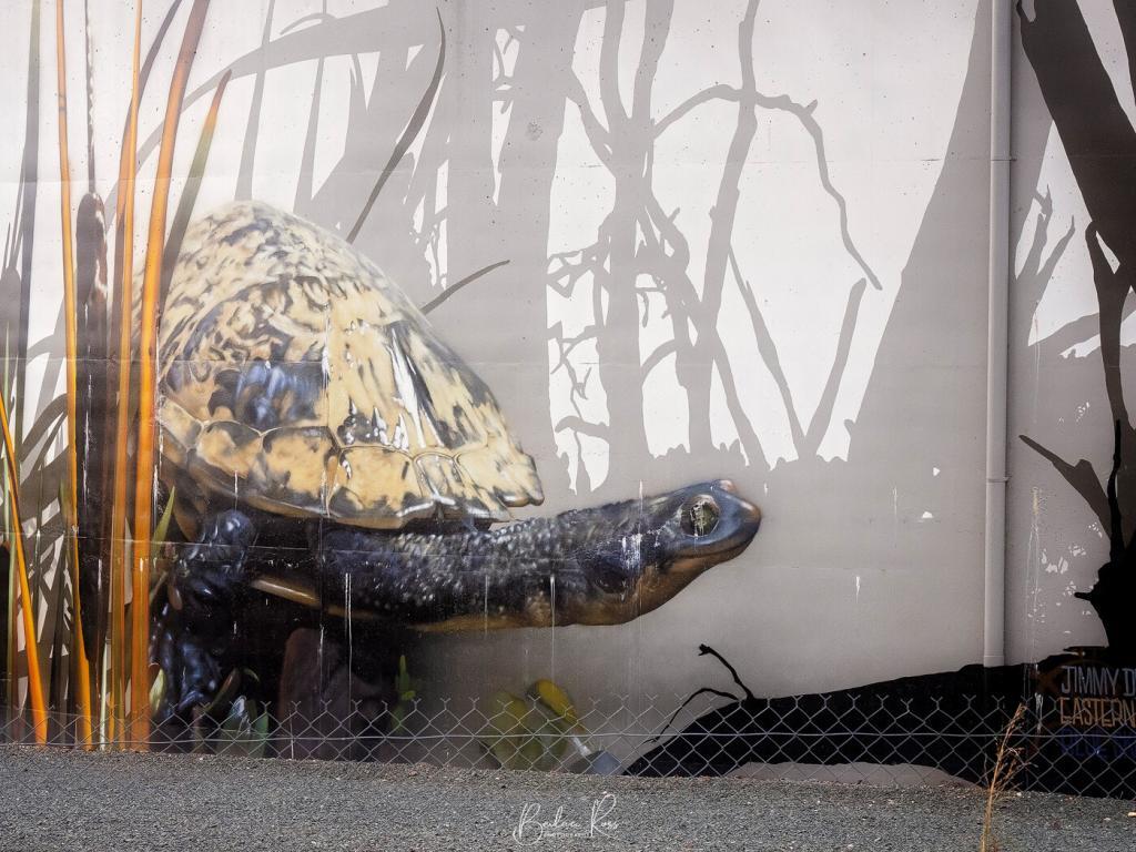
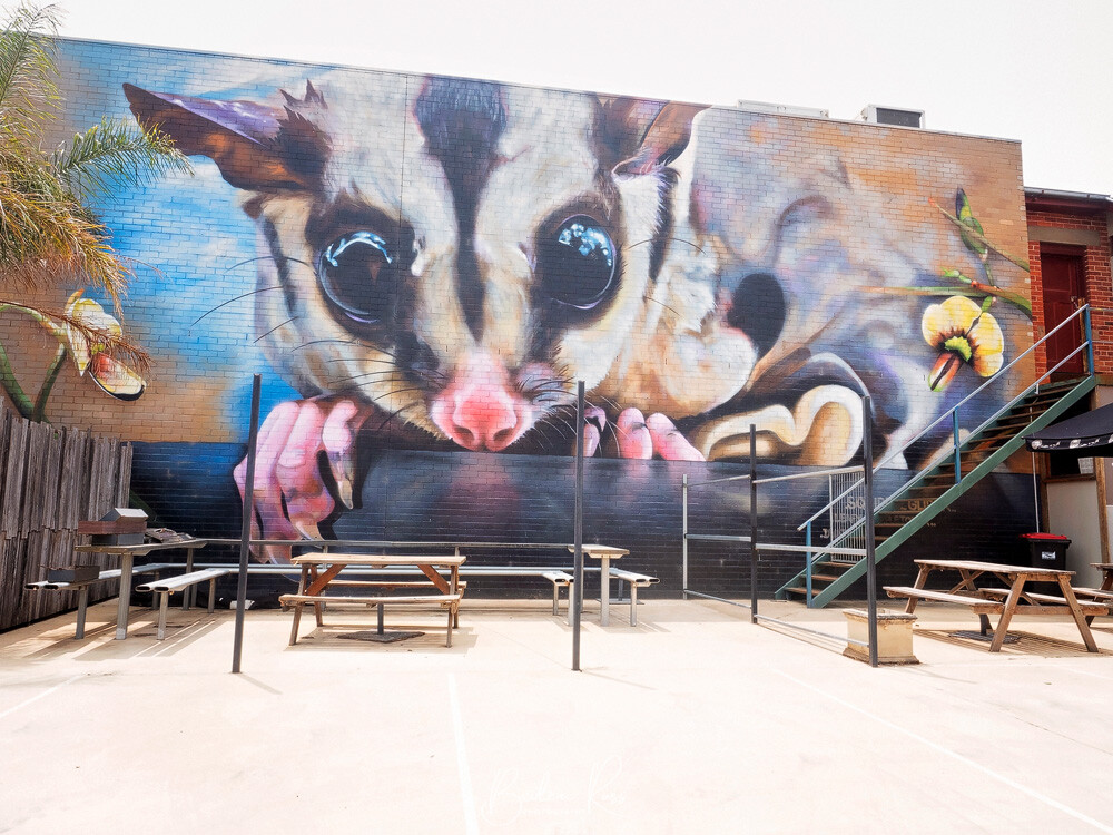
In Victoria, street artists create visually appealing works and use their art to bring attention to social issues and promote various causes. Their murals and graffiti often convey compelling messages about environmental conservation, mental health, inclusivity, and social justice. In rural areas of Victoria, murals and silos frequently feature local wildlife. Street art, therefore, acts as a platform for activism and encourages positive change.
Inner city Hotspots
While street art can be found throughout Victoria, some areas have become well-known as important hubs for street art.
Brunswick
This suburb in Melbourne is a hub of street art. Stroll along Lygon Street and Sydney Road to uncover an array of vibrant and meaningful murals and graffiti. All highlight the artistic and cultural richness of the area.
Fitzroy and Collingwood
These urban areas are hubs for dynamic street art culture. Stroll through the streets, alleys, and laneways, and you’ll come across numerous murals, stencils, paste-ups, and graffiti pieces. Johnston Street, Brunswick Street, and Smith Street are especially abundant with street art.
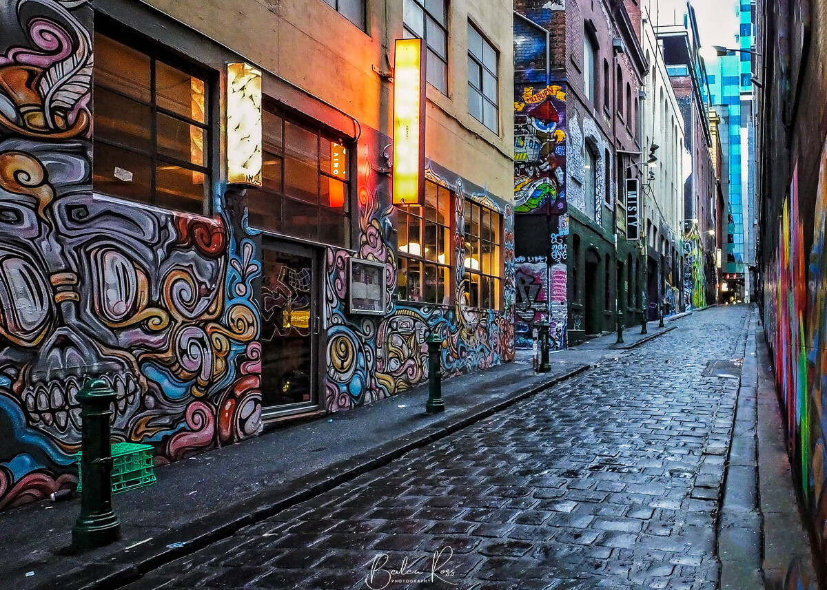
Hosier Lane
A quaint cobblestoned alleyway near Flinders St. Station has become a dynamic, ever-changing outdoor gallery.
Street Art Towns
Benalla Wall to Wall Festival
Benalla is considered the street art capital of regional Victoria. Every year, they hold the Wall to Wall Festival of street art, which features incredibly talented and well-known street artists from all over the country and the world. They create breathtaking murals and street art on the walls of buildings around the town. If you’re looking to explore the 65 murals on the art-filled streets of Benalla, you can take a self-guided walk and make the most of your experience by using the Storytowns-Benalla Street Art app. Don’t forget to grab a street art walking map from the Visitor Centre!


Bendigo
Another regional centre located in Victoria has incorporated street art into its cultural landscape. The Bendigo Street Art project has brought stunning murals to various locations around the city.
Geelong
Geelong, a city in the southwest of Melbourne, has a thriving street art culture. The lively alleys and walls near Little Malop Street have become attractive outdoor galleries, giving the urban landscape character and creativity.
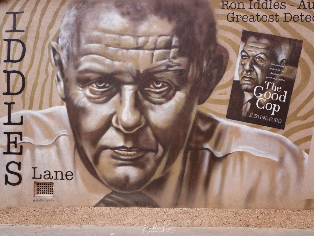
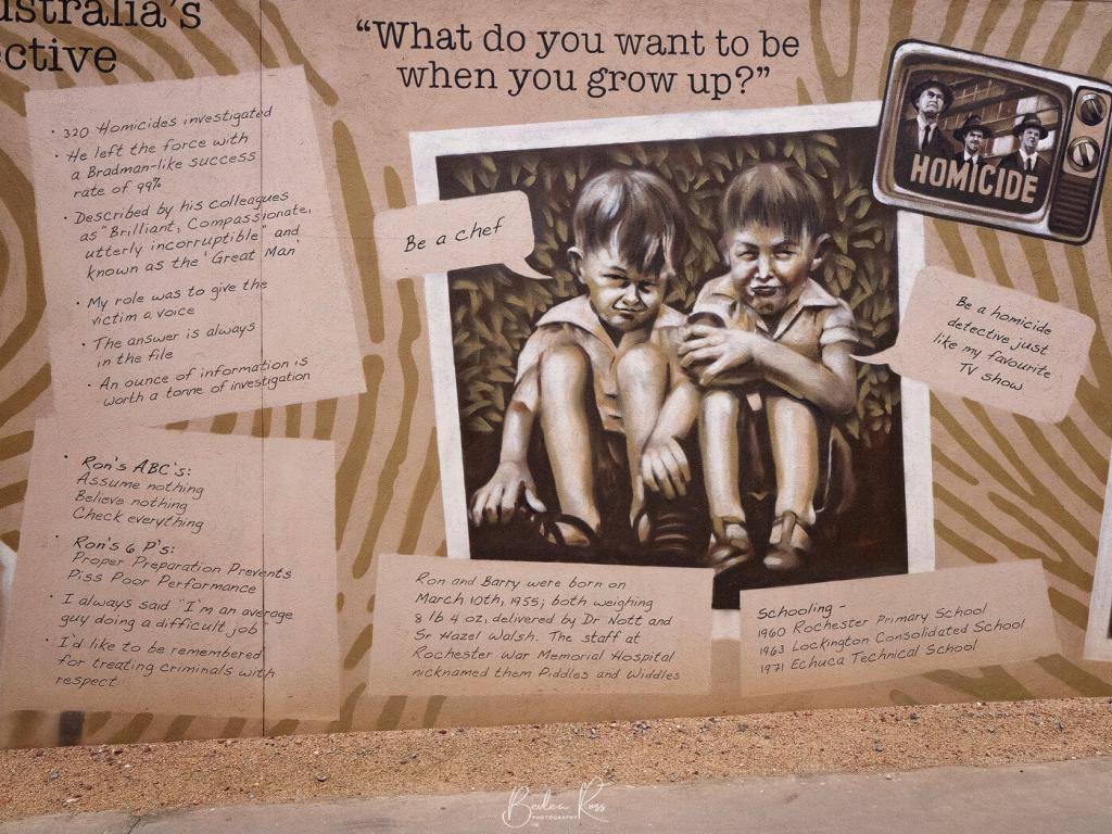
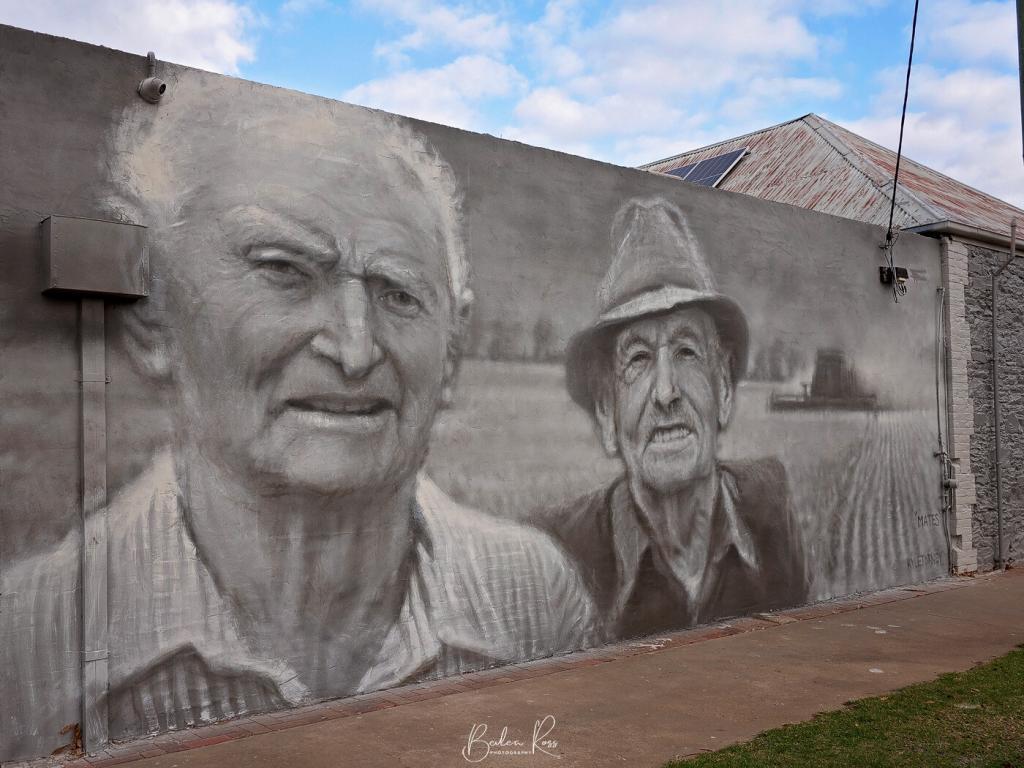
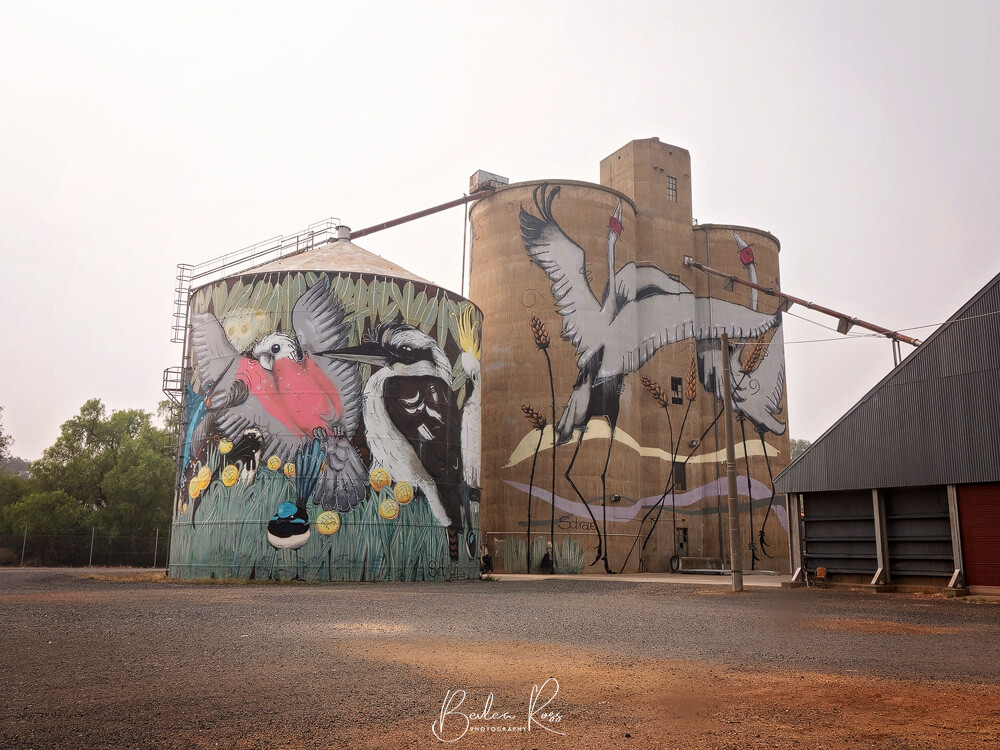
Rochester
Rochester is a town in the Campaspe shire that boasts impressive art installations. In this area, there are two silos that Jimmy Dvate has painted. Additionally, there is a laneway that features the artwork of Tim Bowtell on both walls. This laneway has been recently named Iddles Lane in honour of Ron Iddles OAM APM, an accomplished Australian police detective who had a remarkable conviction rate of 99%. His exceptional performance earned him the title of “Australia’s greatest detective.”
St Arnaud
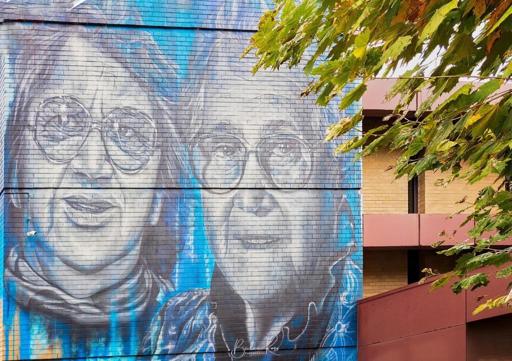
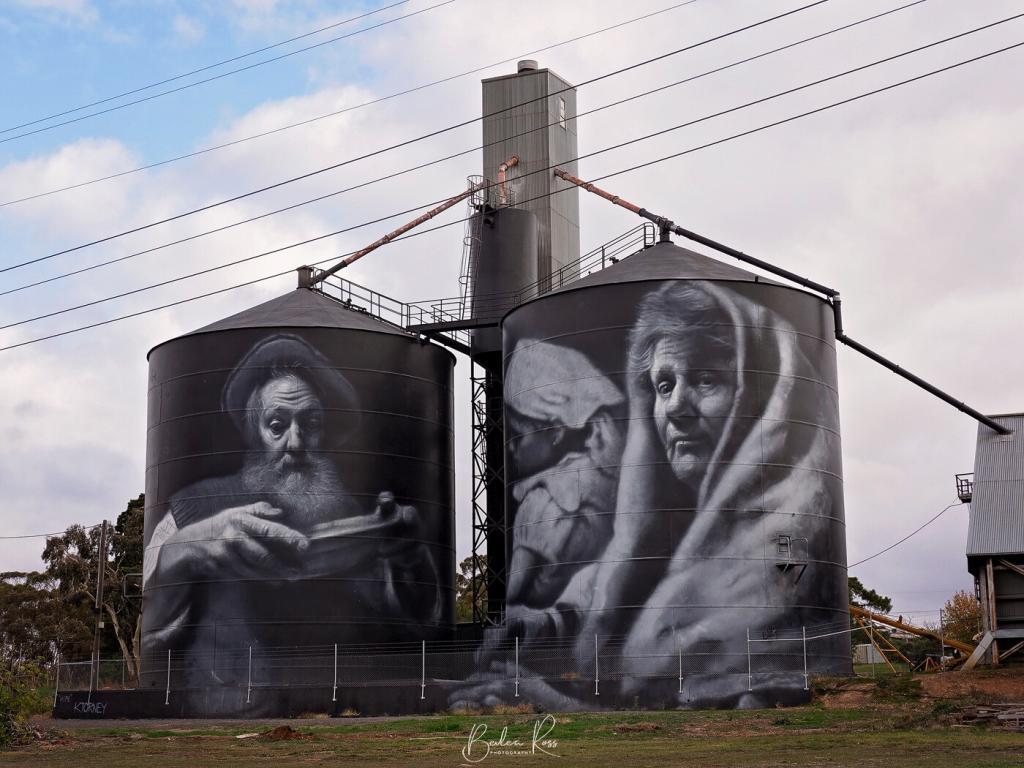
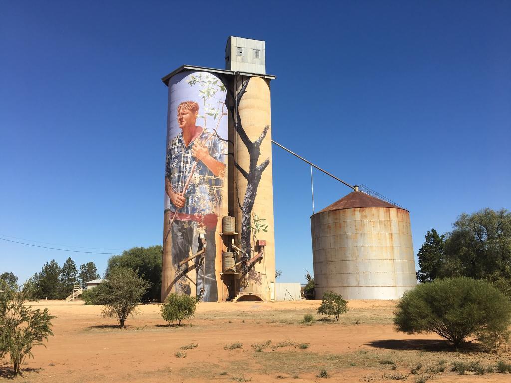
St. Arnaud is a town between Avoca and Donald and was once a central place for gold mining. Kyle Torney, a skilled muralist and oil painter, is a resident of St. Arnaud and has gained recognition in the street art community for his Renaissance-style artwork. His pieces showcase local stories with great attention to detail. Coincidently, St. Arnaud is the region’s starting point of the Silo Art Trail and is a great place to stay overnight before you start the Trail the following day.
Warrnambool
Impressive murals and street art collections can be found in the coastal town of Warrnambool. The CBD and laneways feature colourful artworks that reflect the town’s beauty and local themes.
Shepparton
Shepparton has approximately ten street art spots and its award-winning Moooving Art herd. The locals have named ‘Dana Djirrungana Dunguludja Yenbena-l’ to the Aboriginal Street Art Project, which translates to ‘Proud, Strong, Aboriginal People’ in the Yorta Yorta language. The project aims to honour the area’s Aboriginal heritage and traditions while connecting the newly constructed SAM (Shepparton Art Museum) with Shepparton CBD.
Yarram
The small township of Yarram is in southeast Gippsland, 221 kilometres east of Melbourne. It’s a two-and-a-half-hour drive down the Princes Highway car.
Yarram boasts impressive artwork by Heesco, a well-known artist from Ulaanbaatar, Mongolia. Heesco relocated to Australia in 2010 and settled in Melbourne, where he has been busy painting walls across the country, including some silos in New South Wales. Yarram has ten outdoor murals and five indoor murals to enjoy. Yarram was also the Gold winner of the 2020 Street Art Awards.

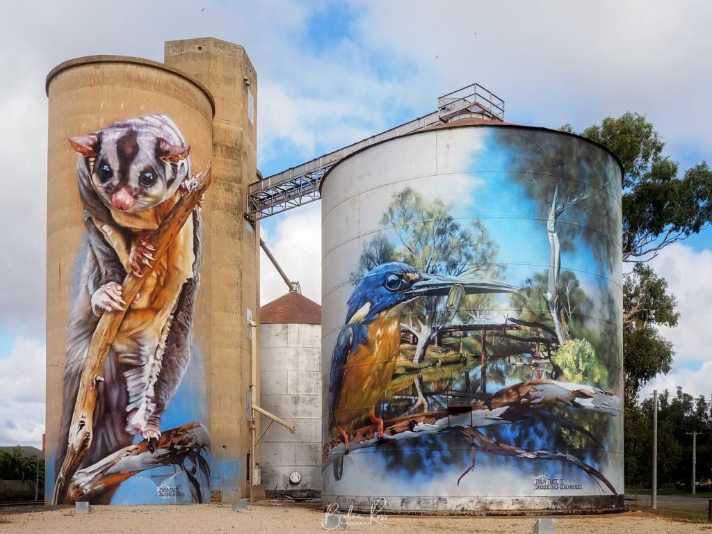
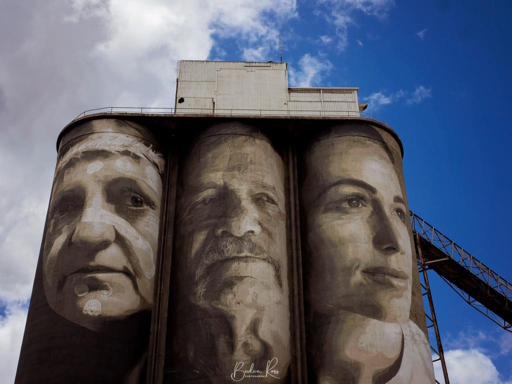
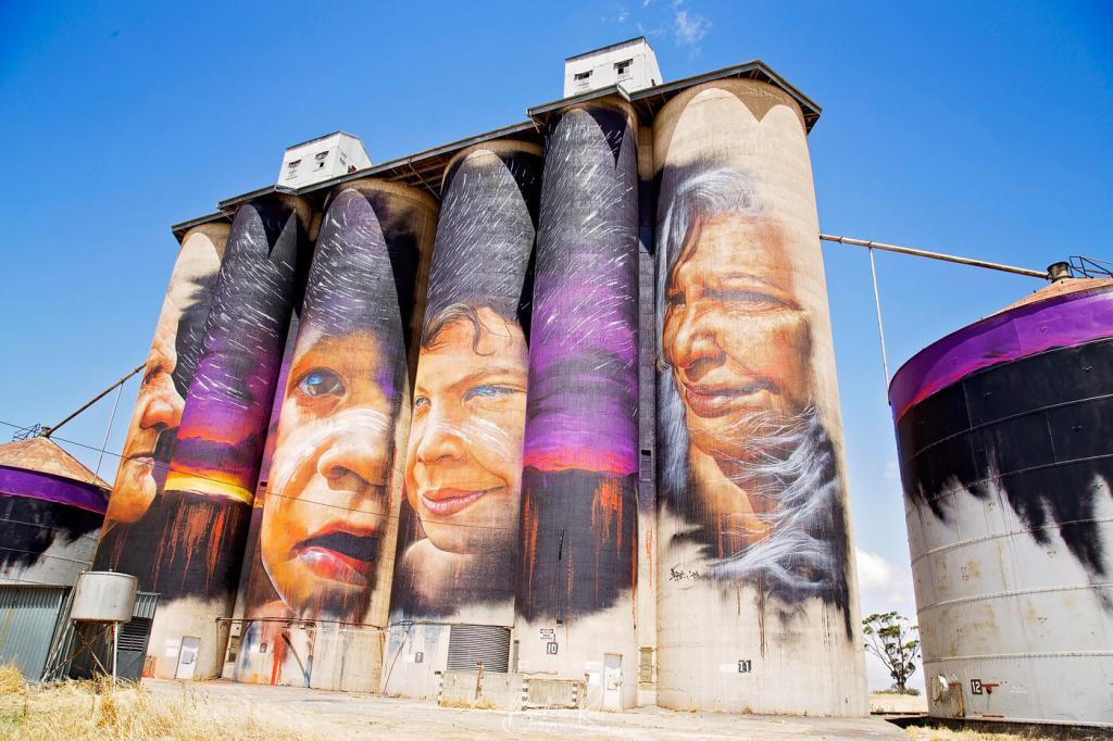
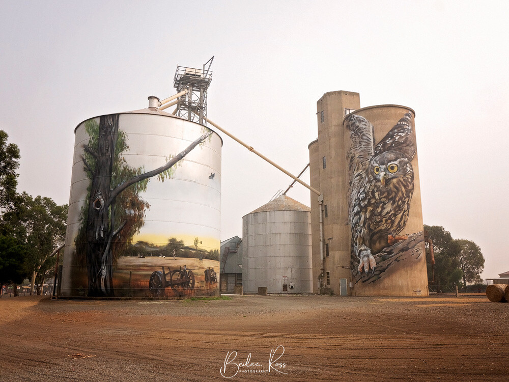
While other states also have painted silos, Victoria has the most painted silos standing at 26, as of July 2023. Only Victoria has a drivable trail with only 50-60 km between each silo. And Victoria has three separate Trails at that! The Silo Arts Trail and the Northeast Silo Trail are in regional areas. These trails are a one-of-a-kind public art project in regional Victoria, Australia, that’s truly amazing.
Silos as a canvas
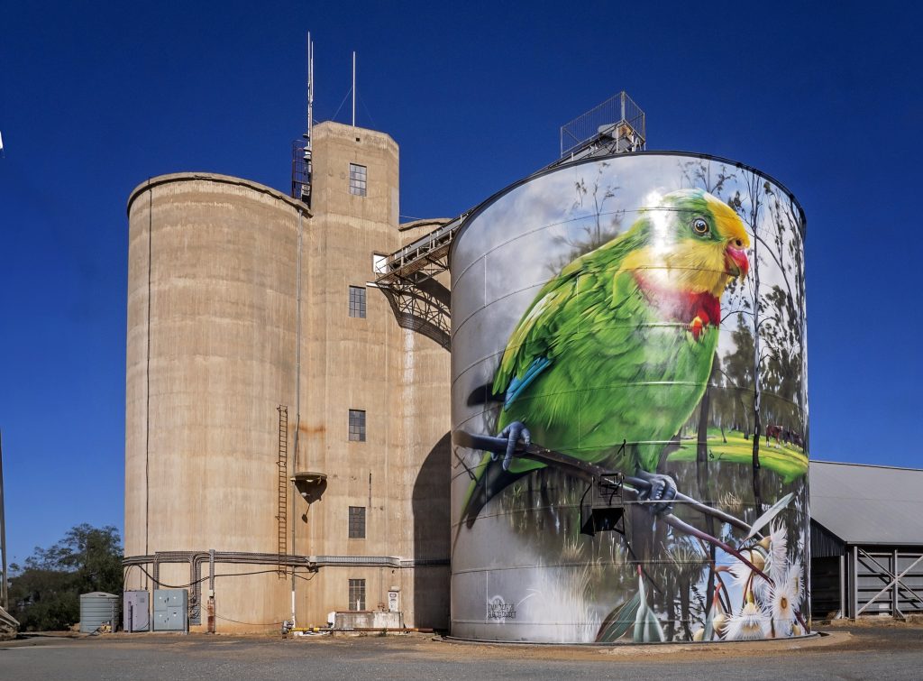
This unique project aims to turn rural landscapes into an open-air art gallery. Northam, Western Australia, was the first official silo artwork in 2015, created by Phlegm and HENSE. However, the Silo Trail concept was initially launched by the Yarriambiack Shire Council in 2016. Since then, talented artists from Australia and all over the globe have been invited to paint these silos with their artistic interpretations.
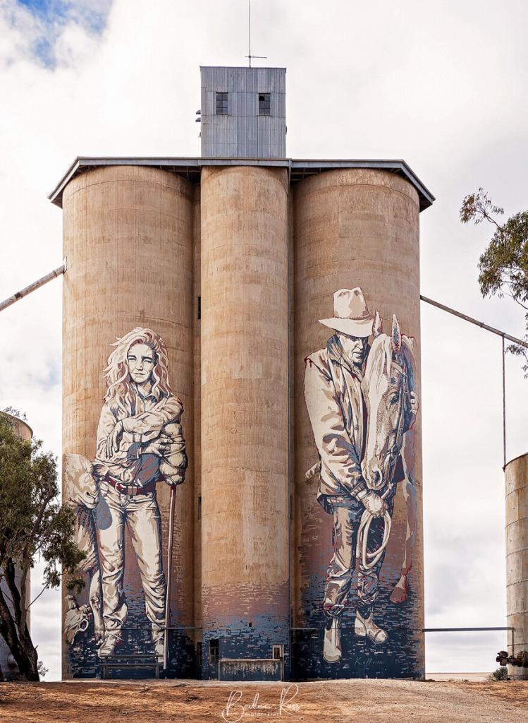
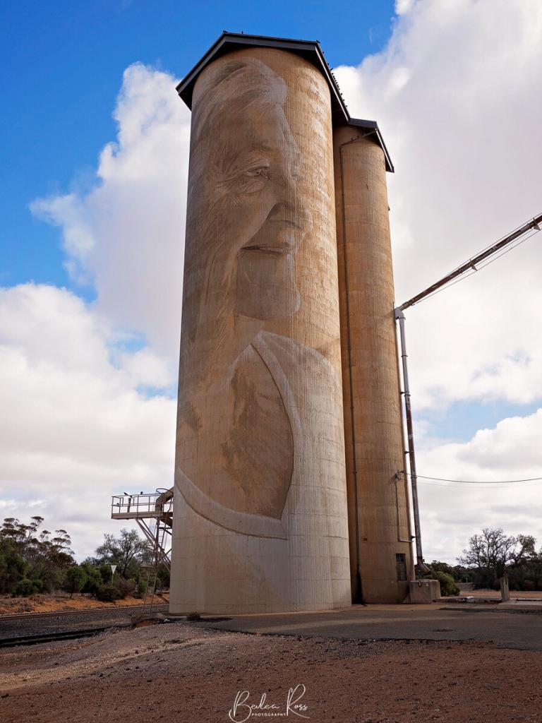
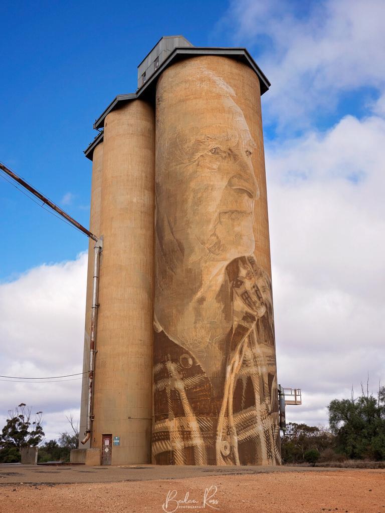
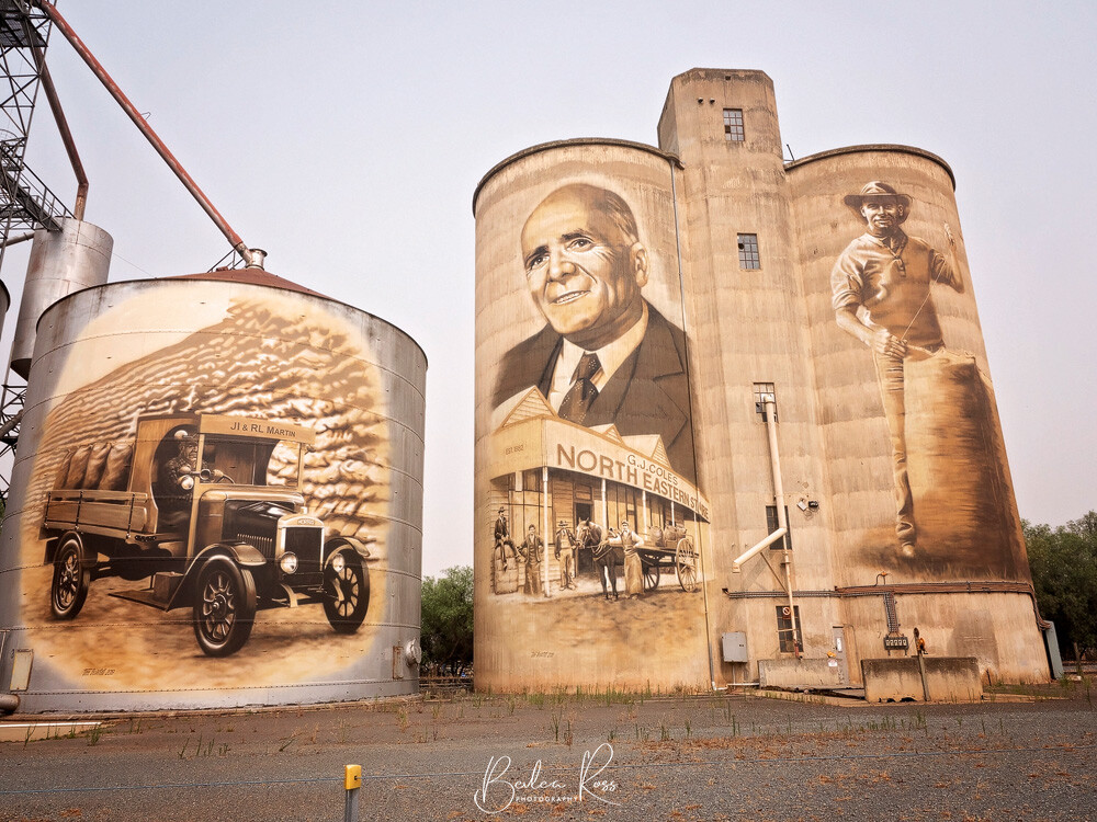
The painted silo artwork is by famous street artists such as Rone, Adnate, Dvate, Guido Van Helton, Kaff-eine and others, who use these towering silos as their canvases to create impressive artworks that celebrate the local communities, culture, and history.
The Silo Art Trail
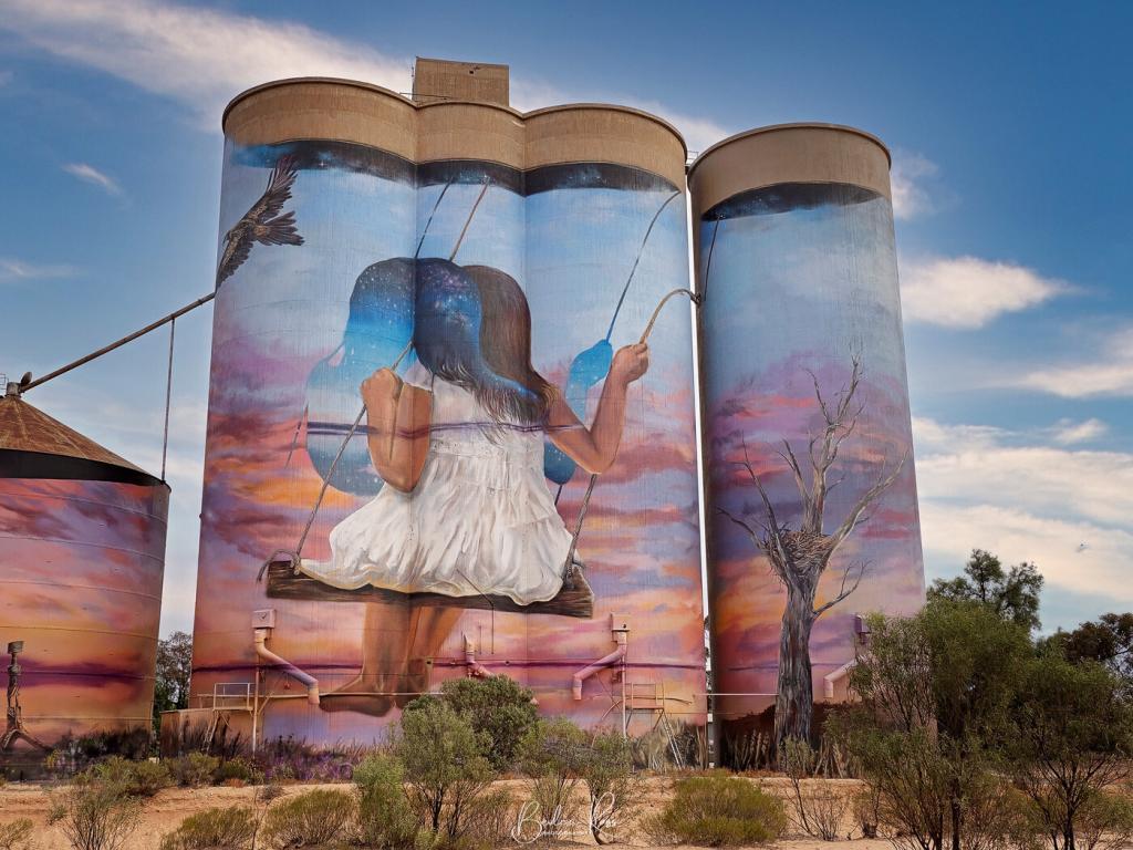
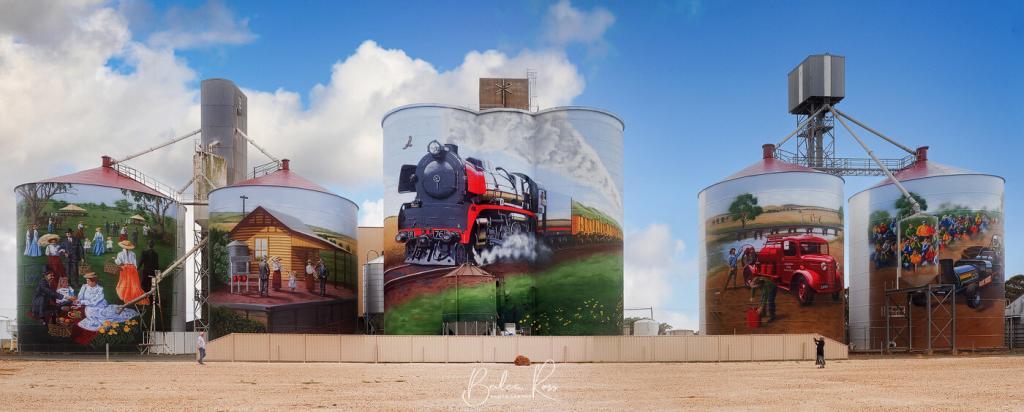
The original Silo Art Trail in Northwest Victoria started in 2016 and stretches 350km across regional Victoria, where the silos are strategically located in small towns along the trail. The artwork celebrates the people and culture of the region and adds an artistic touch to the picturesque countryside. Towns that feature painted silos (in driving order) are:- St Arnaud, Rapanyup, Murtoa, Horsham, Sheep Hills, Brim, Lascelles, Walepeup, Sea Lake and Nullawil, with more being added all the time.

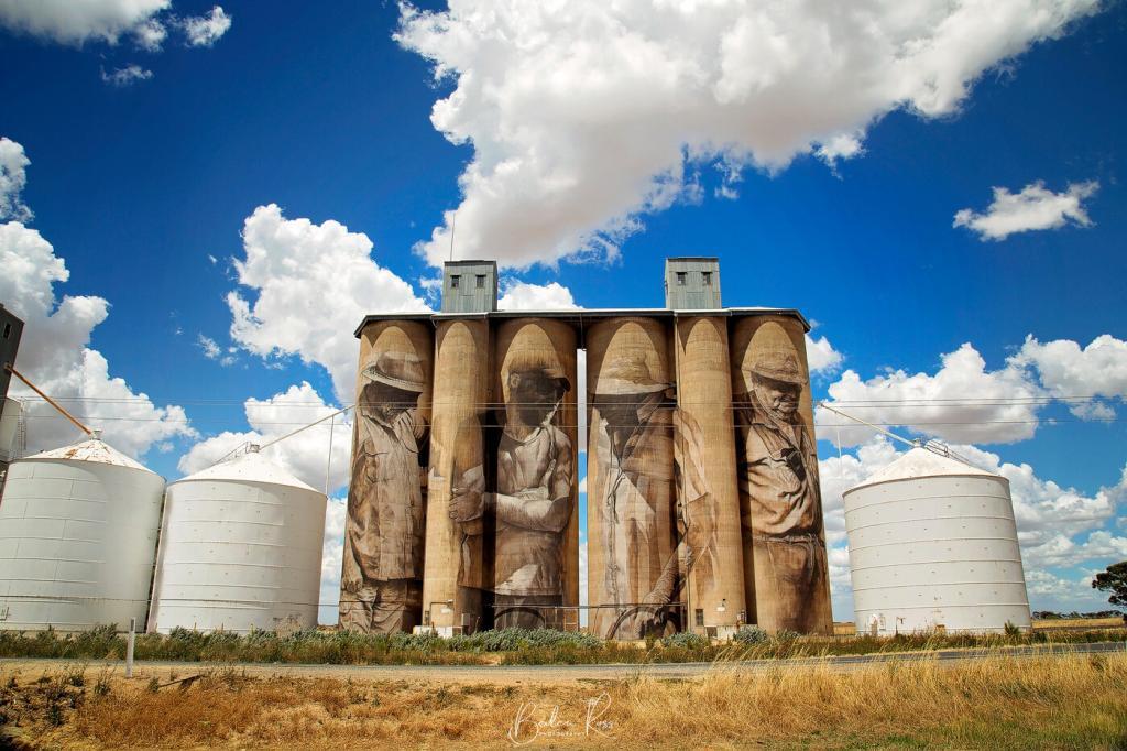
North East Silo Trail
The North East Victoria Silo Art Trail began in 2018 and spans 132km. It starts just outside Benalla and takes approximately two hours to complete. Talented artists, including Guido Van Helten, Sobrane, Cam Scale, Adnate, Dvate, and Tim Bowtell, a local artist from Benalla, created the silos along this trail. The first town, Goorambat, has four works of art, including the interior wall of the Uniting Church.
From there, it goes to Devenish, St James, Katatamite and Tungamah. The CFA Water tank at Winton Wetlands is a must-see on returning to Benalla. A North East Trail map is available for download.
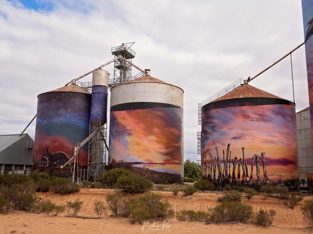
Winton Wetlands
The Winton Wetlands Art in the Landscape project aims to improve the visitor experience and raise awareness about the ecological significance of the wetlands by incorporating art installations and sculptures throughout the area. Among these installations are the CFA water tanks. The tank depicts the faces of three CFA firefighters on its side. While in Winton, they are still part of the North East Silo Trail.
Guido Van Helton was commissioned in 2016, as part of the Wall to Wall Street Art Festival in Benalla, to paint the water tank in the heart of the Winton Wetlands.
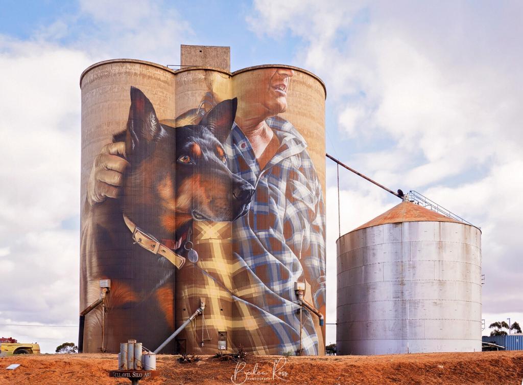
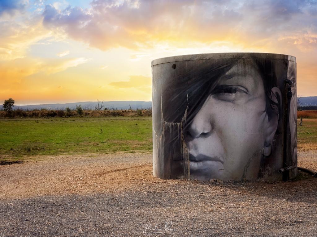
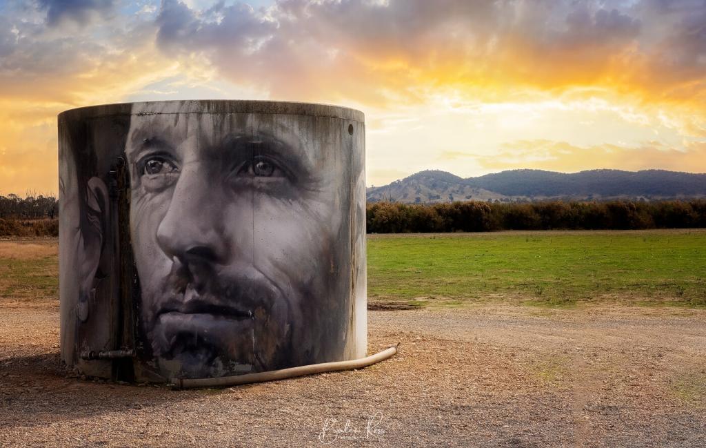
Echuca-Moama Silo Trail
Echuca Moama and its surrounding regions house four silo and water tank art installations. The Echuca-Moama trail can be done in a full day, but can also be split it into two half-day drives. The total driving time, without any stops, is roughly between 3.5 to 4 hours.
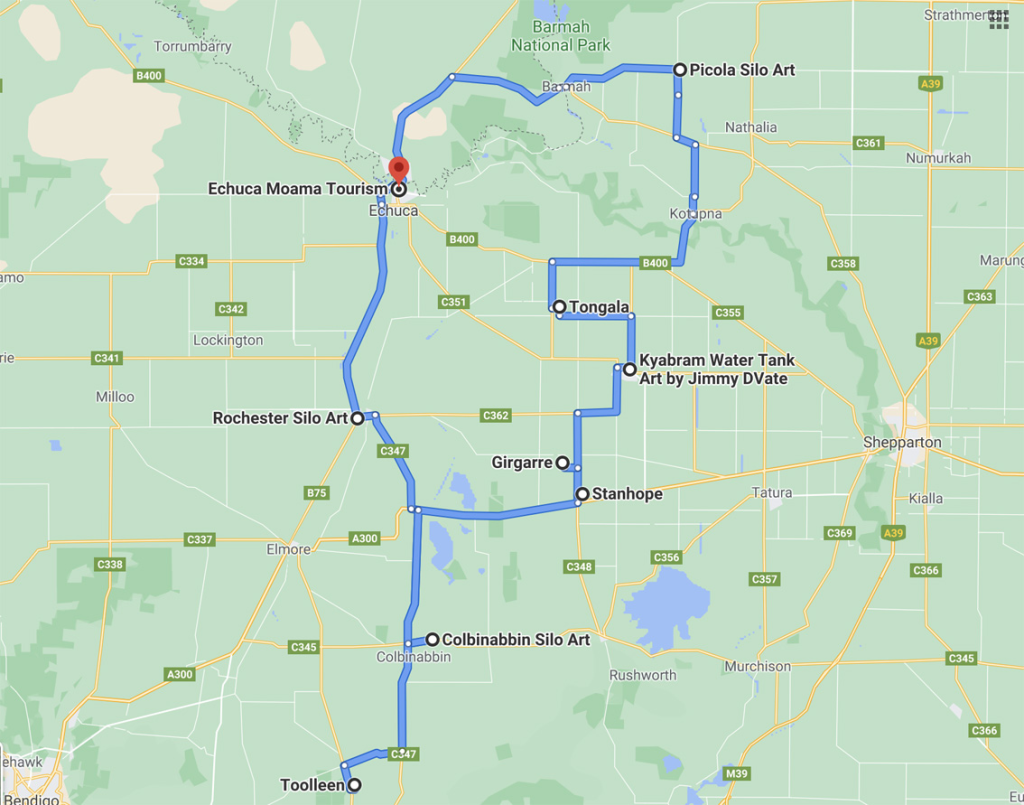
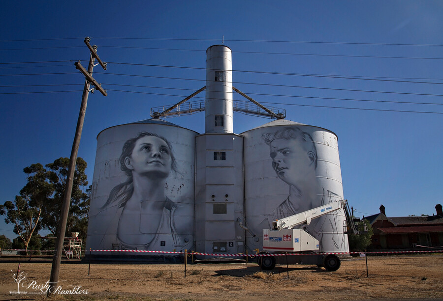
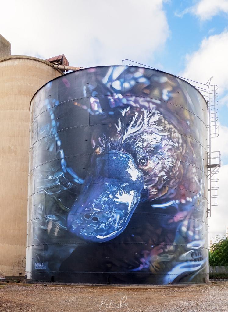
From Echuca, it’s a short 25-minute drive to Rochester where there are two silos painted by Jimmy Dvate. While n Rochester check out Iddles Lane featuring murals painted by Tim Bowtell celebrating Ron Iddles one of the state’s most respected detectives
It takes approximately 25 minutes to drive from Rochester to Colbinabbin. In 2020, artist Tim Bowtell painted the silos in Colbinabbin, showcasing important moments from the town’s history. These moments include the town’s connection to agriculture, community, environment, and the construction of the railway.
The final destination is Picola, which is located 35 minutes away, again painted by Jimmy Dvate. The artwork showcases the culturally significant Barmah National Park and the various wildlife that inhabits it. After visiting Picola, it will take another 30 minutes to return to Echuca.
Woomeland Field Bins
Explore Woomelang’s unique Mini Silo Art Trail, which offers a creative twist on the well-known Big Silo Art Trail. This trail features eight Mini Silos (Field Bins) scattered throughout the town, providing a fun and exciting way to discover the area. The Mini Silos celebrates the endangered species of the Mallee region.
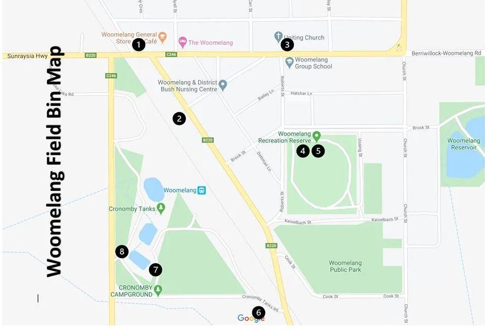
In June 2020, a group of seven artists, including Jimmy DVate, Andrew J Bourke, and Kaff-eine, converted mini silos into a popular tourist attraction for the town. The mini silos showcase endangered species that are native to the area.


The Silo Art Trail showcases the transformative power of art in enriching communities. This painted silos project has revitalised rural Australia by using ordinary grain silos as canvases for extraordinary murals, providing an unparalleled cultural experience for both locals and visitors. As you travel along the trail, you will witness breathtaking artwork and become part of the collective effort to preserve the essence of regional Australia.
The Silo Art Trail symbolises resilience, creativity, and the indomitable spirit of the Australian outback. So, pack your bags, hit the road, and let the vibrant stories told by the silos take you on an unforgettable adventure!

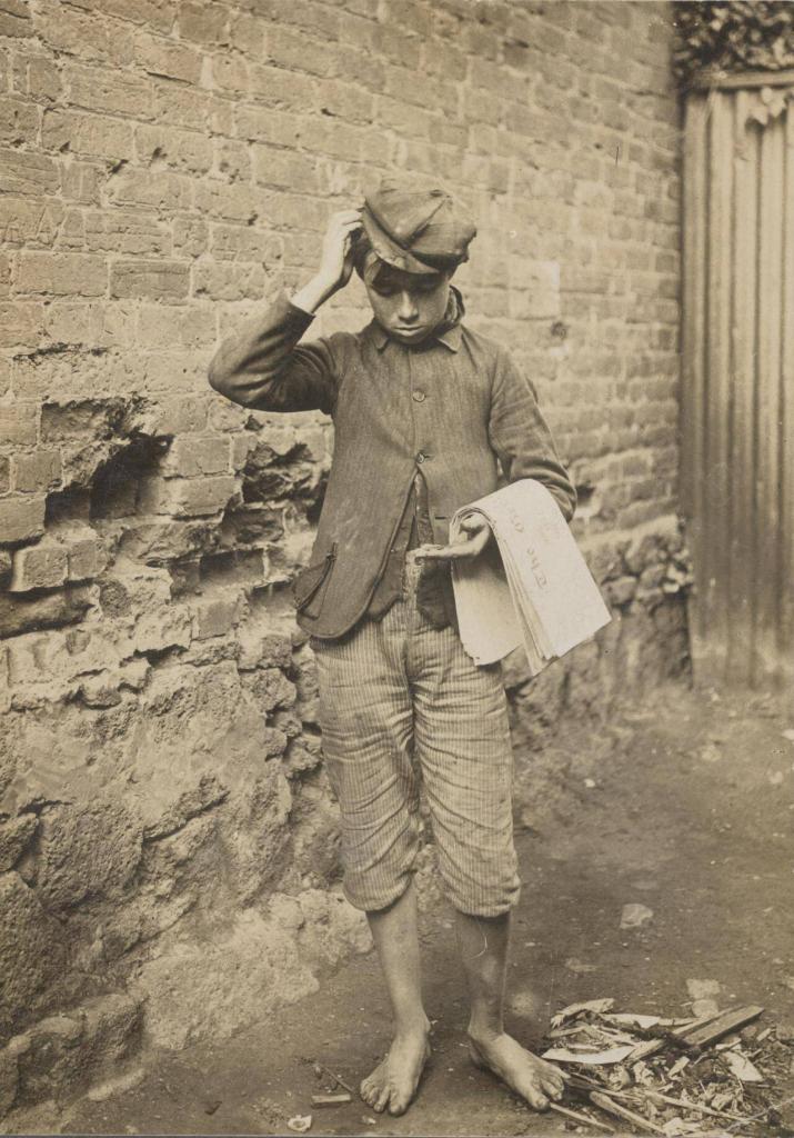
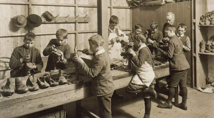
Melbournes newsboys were a familiar sight on the city’s streets from the mid-19th to the mid-20th centuries. They were typically young boys from poor families who sold newspapers to earn a living. The first newsboys in Melbourne appeared in the 1840s, and their numbers grew rapidly in the following decades. By the 1890s, an estimated 2,000 newsboys were working in the city.
Newsboys, usually aged between 8 and 16, often worked in challenging conditions for long hours. They braved the elements and were sometimes subjected to violence from customers or other newsboys. You could find them at popular locations such as Flinders St Station, the Town Hall, Young and Jackson pub, theatres, and other pubs. These spots were highly sought-after by newsboys as they were perfect for distributing newspapers.
The Rise of the Newsboys
During the late 19th and early 20th centuries, Melbournes newsboys emerged as an integral part of the urban landscape. Armed with stacks of newspapers under their arms, these young entrepreneurs eagerly took the day’s news to the city’s residents. Often hailing from lower-income backgrounds, these young boys found an opportunity to earn a living and contribute to their families’ financial well-being.
In 1891, the Education Department convened a special committee to consider what would be done about the city’s neglected children. It was estimated that upwards of 10,000 children were not attending school at all. The report recommended that newsboys be licensed and wear a badge displaying where they went to school. No boys under 17 should be allowed to trade on Saturday nights after 8 pm or 9 pm. Girls under 18 years of age were forbidden to apply for a licence at all.
The newsboys were a diverse group, coming from various cultural backgrounds and ages ranging from as young as six to teenagers. They were a familiar sight to Melburnians, darting through the streets, their voices echoing with the cries of “Extra! Extra! Read all about it!” as they offered the latest editions of newspapers.
Life as a Newsboy
Many city newsboys were often barefooted rather than wearing boots so they could run faster. The boys had their own pitches, gangs and hierarchies — the leader of the mob could have his mates around him in a trice with a quick whistle. One such gang was Crutchey, Tabby-cats, Spud, Little Charlie, Snowy, Curley, Sport, Jack, Cock-eye, Battler, Spud, Fossie, Dicko, Soldier, Morry, Tom, Ginger, and all their mates.
Being a newsboy was a tough job, and the young entrepreneurs who did it had to overcome many challenges and obstacles. They had to endure harsh weather conditions, carry heavy newspapers, and navigate through chaotic city streets. Their success depended on their salesmanship skills, as they had to persuade people passing by to buy the newspapers they were selling.

When not selling papers, the boys had a reputation for roaming the alleyways: ‘whiffing cigarettes, chewing tobacco, swearing and fighting,’ or gambling their earnings in the game, ‘pitch and toss’
Running afoul of the law
By the turn of the century, many saw newsboys as a public nuisance. Lawmakers began charging them under an obscure council by-law, which prescribed that: “No person shall make any violent outcry, noise or disturbance in or on any of the streets, carriageways, footways, or public places within the City of Melbourne to the annoyance of any person or persons frequenting the same“.
Boys could also be charged for using fictitious headlines to lure passersby to purchase their newspapers. In February 1914, newsboy John Quilty was fined one pound for calling out: ‘Herald, final edition, a full account of the Fern Tree Gully railway accident.’
The headline about an accident was a work of fiction. Constable A.E. Strickland led the effort to apprehend newsboys shouting on the streets, accusing them of causing a “violent outcry” (as reported in Truth on June 28, 1903). As a result, many of these newsboys were brought to court, fined, and given a week to pay. They would be incarcerated for a week if they failed to pay within that timeframe.
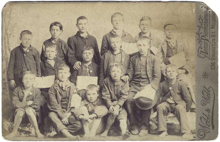
The Newsboys Foundation
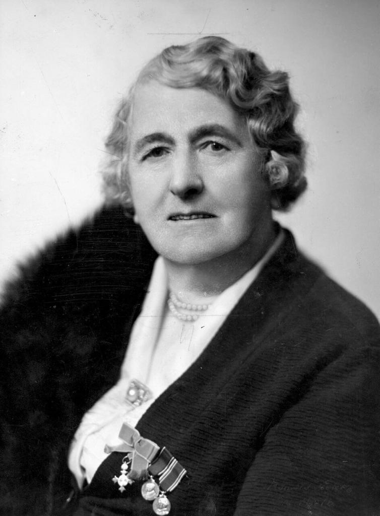
Miss Edith Charlotte Onians, a 28-year-old woman from a devout and wealthy Anglican family, began dedicating her life to helping underprivileged boys in Melbourne. With her help, life for the boys improved in the 1920s. Onians played a significant role in establishing and developing the Newsboys Foundation in Melbourne, Australia.
Photograph by L. Shea. Courtesy of Mitchell Library, State Library of New South Wales; 9624429
On a wet afternoon late the previous year, she had come across the first of Melbournes newsboys as they waited for a delivery of papers. They were floating bits of wood with improvised sails down the flowing gutters, wagering their pitifully small earnings on the race. Most were intermittently homeless. They slept rough on the Yarra riverbank or in the Richmond paddock by the old morgue. None could read or write.
Young boys who worked as newsboys during the early 20th century faced numerous difficulties, such as poverty, limited educational opportunities, and harsh living conditions. Moreover, they were at high risk of being victimised by sexual predators. Onians was aware of these challenges and dedicated herself to finding solutions. She became involved with the City Newsboys’ Try Society, founded in 1893 and later known as the Melbourne Newsboys’ Club. She started volunteering there and asked the boys if they would attend a school class if she organised one. They agreed to try it out. It was the beginning of her lifelong commitment to the cause.
The Newsboys Homes
The Newsboys’ Homes were established as safe havens for newsboys, offering them shelter, education, and guidance. Onians believed in providing these young boys with a nurturing environment where they could grow, learn, and thrive. The Homes provided accommodation, educational opportunities, and vocational training, empowering the boys to break the cycle of poverty and build a better future for themselves.
Over time, the Newsboys Foundation expanded its reach and broadened its scope to include support for disadvantaged youth beyond Newsboys. The organisation extended its programs to include scholarships, mentoring, and funding for educational initiatives. Over the years, it continued to adapt and evolve to meet the changing needs of young people in Melbourne, focusing on empowering them to reach their full potential and succeed in life.
The introduction of the Street Trading Act in 1958 meant that no boy under the age of 12 was allowed to sell newspapers in Melbourne. Those between the ages of 12 and 14 could only do so with a licence. The newsboys of Melbourne left an indelible mark on the city’s cultural and historical narrative.
Education pays off
Onians believed that no child was irreclaimable, and she proved that tenfold through the Foundation’s providing education to the boys. More than 20,000 boys passed through the Foundation, with many succeeding greatly in their respective fields. Melbournes Newsboys went on to become religious ministers, barristers, dentists, and notable sportsmen. Victorian boxing title-holder Norm Gent and former amateur welterweight champion Bill Seewitz were particularly noteworthy among the athletes. Champion wrestlers Bill Davies, Paul Buckley, Olympian Bob Clarke, and footballers Fitzroy captain Alan (Butch) Gale and North Melbourne skipper Les Foote were also among the accomplished athletes. In addition, former newsboy Vic Hartney became a jockey and won the 1943 Melbourne Cup on Dark Felt, while Len Woodhouse became the Australian middleweight weightlifting champion. Basketball players included All-Australian Tommy Nash and state representatives Eric Lund and Norm Davenport.
Reproduced courtesy State Library Victoria
Among the former newsboys were a librarian, several mayors, a president of the Returned Sailor’s, Soldier and Airmen’s Imperial League of Australia, a special magistrate of the Children’s Court, several tram conductors, a bookie, and a successful chef with a thriving business. All in all, 626 boys signed up and fought in WWI, with some losing their lives at Lone Pine, the Somme, North Africa, and the skies over Germany in WWII. However, thousands of other newsboys became exemplary fathers, devoted husbands, diligent workers, compassionate businesspeople, and conscientious members of society.
The Legacy of the Newsboys
The memorable cries of “READ ALL ABOUT IT!” or “Get your “ERRR-AAALD!” still echo in our minds. These newsboys played a crucial role in shaping public opinion and spreading information. Their infectious enthusiasm and unwavering dedication to sales made them more than just newspaper sellers; they were messengers of the changing times. The newsboys of Melbourne were not just people who sold newspapers. They embodied resilience, determination, and entrepreneurial spirit. In doing so, they became essential to the city’s history and helped the news industry grow.

Travel photography is all about capturing the essence of people. The landscapes, cultures, and experiences that one encounters while exploring different parts of the world. It is a visual diary, a record of one’s travels. It aims to transport viewers to unfamiliar destinations, evoking a sense of place. It’s also like a time capsule, preserving memories from a trip that can be cherished and enjoyed for years to come.

What is Travel Photography?
While travel photography is its own genre, it also encompasses food, landscape, portrait and street photography. In addition, every travel destination has its distinct characteristics, such as its culture, history, people, landscapes, and stories.
This entails capturing the beauty of the natural environment, exquisite architecture, local customs, and lively street scenes. It also includes people’s interactions within their cultural settings. Moreover, the photographer endeavours to capture the destination’s essence and create images that inspire viewers to explore and experience the world. Thus revealing its unique features through visual storytelling.

One Example
Picture yourself taking a road trip on the renowned Great Ocean Road in Australia. While driving along the rugged Victoria coastline, you come across the breathtaking Twelve Apostles. A striking formation of limestone stacks towering above the Southern Ocean. You position your camera on a cliff’s edge and capture the dreamy golden sunlight enveloping the apostles in a warm glow during the golden hour.

By carefully composing the scene, one can emphasize the striking contrast between the vivid blue ocean, the rugged rocks, and the dramatic sky overhead. You also effectively capture the crashing waves against the apostles, creating a dynamic and powerful image. One depicting nature’s raw beauty and immense power.
Your photograph captures a defining landmark of Australia’s coastline, showcasing the natural wonders of the Great Ocean Road. It invites viewers to immerse themselves in the breathtaking scenery, inspiring them to explore the country’s diverse landscapes. In addition, the image serves as a reminder of the vastness and awe-inspiring sights that Australia has to offer.

What Gear?
When taking photos while travelling, it’s crucial to balance having the right equipment while ensuring that your gear is lightweight and easy to carry. Here are some essential equipment suggestions for travel photography.
- Camera: When selecting a camera, it’s important to consider your specific needs and preferences. You have several options to choose from, including compact point-and-shoot cameras, mirrorless cameras, and DSLRs. Consider factors like image quality, size, weight, and versatility to make the best decision.
- Lenses: When packing for your trip, aim to bring a variety of lenses that can cover different focal lengths. A wide-angle lens, typically around 16-35mm, is ideal for capturing landscapes and architecture. On the other hand, a zoom lens like the 24-70mm or 70-200mm offers versatility for various types of shots.
- Tripod: For steady shots, long exposures, and self-portraits, a lightweight and sturdy tripod is essential. It’s important to find one that is compact and easily fits into your travel bag for convenience. (Carbon fibre tripods are the lightest).

Equipment is not just the camera.
- Extra Batteries and Memory Cards: Ensure you have spare batteries and sufficient memory cards. Nothing is worse than running out of power or storage space while on the go. It’s always better to have more than you think you’ll need.
- Camera Bag: Investing in a durable and comfortable camera bag is essential for protecting and organizing your gear. It’s important to choose one with padded compartments and convenient accessibility.
- Filters: When taking photos, it’s worth bringing along some useful filters like neutral density (ND) filters to manage the light and polarising filters to minimize glare and intensify colours.
- Cleaning Kit: It’s a good idea to have a compact cleaning kit. Look for one with a lens cloth, blower, and cleaning solution. This will keep your equipment in good condition and achieve dust-free pictures.
- Remote Shutter Release: When taking long exposures or self-portraits, a remote shutter release or cable release can come in handy to minimize camera shake.
- Portable External Hard Drive: It is important to regularly back up your images to avoid losing valuable data and to free up space on your memory card. You can use a portable external hard drive or cloud storage.
- Travel Adapter and Charger: When planning to travel abroad, it is advisable to bring a travel adapter and charger compatible with the destination country’s electrical outlets. This will ensure you can charge your devices and stay connected while travelling.

Tips to get you started
- Plan and Research: Before you travel, research your destination to understand its culture, landmarks, and points of interest. This will help you identify unique and photogenic locations.
- Pack Light and Smart: Travel photography often involves a lot of walking, so it’s essential to pack light. Carry only the necessary camera gear and accessories. Consider a versatile lens that covers a wide range of focal lengths.
- Capture the Local Culture: Focus on capturing the essence of the destination by photographing local people, their daily lives, traditions, and customs. Be respectful and seek permission when photographing individuals.
- Seek Unique Perspectives: Look for different angles and perspectives and experiment with low angles, high angles, and different compositions to add interest to your shots.
- Golden Hour and Blue Hour: Take advantage of the beautiful lighting during the golden hour (shortly after sunrise or before sunset) and the blue hour (before sunrise or after sunset). The soft, warm, and diffused light during these times can enhance your photos.
- Tell a Story: Look for scenes that tell a story or evoke emotions. Include elements that provide context and create a sense of place.
- Pay Attention to Details: Details can often make for compelling photographs. Capture close-up shots of interesting textures, patterns, architecture, or local cuisine to add depth and variety to your travel album.
- Be Mindful of Composition: Use the rule of thirds, leading lines, and framing techniques to create visually pleasing compositions. Consider the foreground, middle ground, and background to add depth and balance to your images.
- Experiment with Long Exposures: If you have a tripod, try long exposure photography to capture motion blur of waterfalls, flowing rivers, or bustling city streets.
- Practice Patience and Observation: Take the time to observe your surroundings, anticipate moments, and wait for the perfect shot. Patience can often lead to capturing unique and memorable images.
Locations not gear
Explore the world! Visiting breathtaking destinations will yield better photographic opportunities than investing in pricey equipment. Don’t underestimate the capabilities of your phone camera either – it can capture stunning shots.

Travel photography can transport viewers to different corners of the globe, fueling a desire to see these awe-inspiring landscapes in person. This is the essence of travel photography: to inspire adventure, ignite wanderlust and encourage appreciation for the beauty of the world’s natural and cultural wonders.

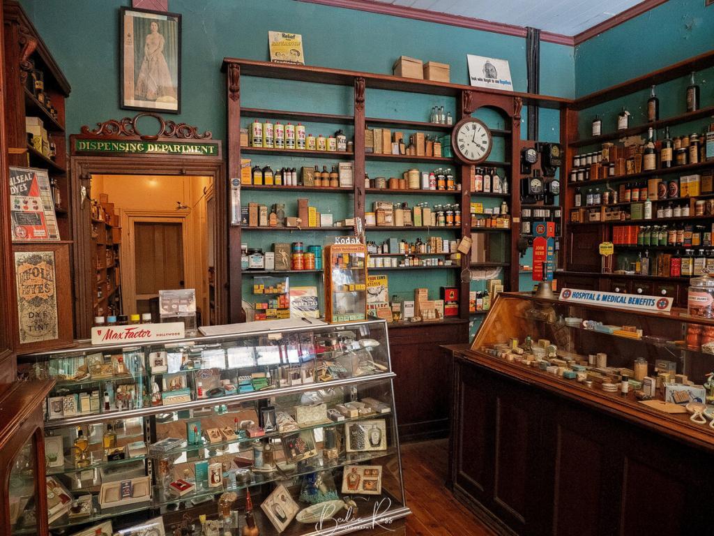
Dows Pharmacy at Chiltern was established in 1859. The pharmacy holds significant historical value as it is one of the few shops that have been preserved in its original state, providing a unique insight into the past. Although it closed in 1968, the pharmacy’s contents remained untouched, making it a unique time capsule of the past.
The Pharmacy was first run by William Witt, who opened the doors in 1859. David McEwen owned the pharmacy from 1864 to 1891. He was the father of the Australian prime minister, John McEwen, who took over the Prime Ministership in a caretaker role upon the disappearance of Harold Holt. In 1929, Hilda Dow purchased the pharmacy. The Dows ran it for the next 38 years until Hilda retired in 1968. During their tenure, the pharmacy became a thriving community hub, providing essential services to the people of Chiltern.
Hilda Dow
Hilda Dow (nee Grey) was the daughter of police magistrate Charles Grey and sister of Royal Melbourne Hospital Lady Superintendent Helene Grey, OBE. She became a student of the Victorian College of Pharmacy in 1919. In 1929, she worked at Poynton’s pharmacy in Morwell, when she purchased the pharmacy at Chiltern in Victoria. She was elected to the Pharmaceutical Society of Victoria as a member in 1930.
Hilda purchased the pharmacy in 1929 on the eve of the great depression. Until they married in 1931, Hilda resided at the hotel across the street while Roy lived in the residence at the back of the pharmacy. After their marriage, Hilda joined him in the residence. Hilda apprenticed Roy in 1933, and the couple ran the pharmacy in Chiltern until 1968 when they closed the doors.

After retiring in 1968, Hilda Dow attempted to sell her pharmacy, but unfortunately, no buyers were interested in purchasing it. As a result, it remained closed and abandoned for many years. Finally, in 1988, Mrs. Dow generously donated the pharmacy to the National Trust. Dows pharmacy is now a museum for visitors to explore. Hilda Dow was also a highly involved member of various organisations, including the North East branch of the National Trust, the hospital committee, the Infant Welfare Centre board, the Red Cross, and the Chiltern Branch of the County Women’s Association, where she held a leadership position.

National Trust
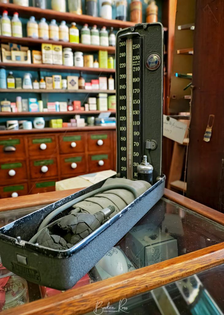
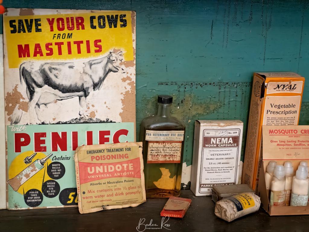
The National Trust now runs the pharmacy as a museum. A collection of more than 4,000 original items offers an fascinating insight into the history of medicine and pharmacy. Visitors can explore a variety of artifacts, such as bottles, jars, scales, measuring cups, dispensing equipment, and displays of medicines, photographic supplies, and shop fittings.
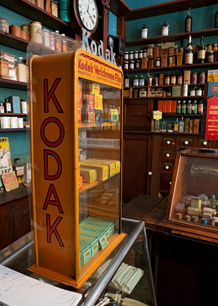
One of the most striking features of Dows Pharmacy is its time capsule-like atmosphere. The contents of the pharmacy were left untouched when it closed in 1968, and as a result, it feels like stepping back in time. The shelves are still stocked with medicines, the jars are still filled with herbs, and the scales are still set to weigh prescriptions.
Hilda and Roy were both active members in the Chiltern community. Roy received an MBE in 1970 for his valuable services to pharmacy in Victoria. Unfortunately, Roy passed away in 1976, and Hilda followed fourteen years later, passing away in a care home at the age of 92.
Fast facts
- The pharmacy was built in the Victorian Italianate style.
- The original fittings and fixtures, including the mahogany counters, brass scales, and glass display cabinets, are still in place.
- The pharmacy’s collection of medicines includes over 1,000 different items dating from the 19th and early 20th centuries.
- The pharmacy also has a collection of photographic supplies, including cameras, lenses, and film.
- Dows Pharmacy was donated to the National Trust of Australia in 1988.

Visiting the Pharmacy
Dows Pharmacy is a valuable historical resource and a fascinating place to visit. It is also a reminder of the important role that pharmacies have played in our communities, and it is a window into the past. If you are ever in Chiltern, be sure to stop by and take a look.
Dow’s pharmacy is open to the public on Tuesdays, Wednesdays, and Saturdays from 11 am to 2 pm. The pharmacy is also available for group tours by appointment.
National Trust Members: FREE
Adult: $5
Concession: $4
Child: $3
Family: $12
42 Conness Street, Chiltern
Canberra is located in the Australian Capital Territory and serves as the capital of Australia. It is a uniquely planned city created to function as the center of the nation’s government, politics, and administration. Despite being Australia’s capital, Canberra is often underrated as a tourist destination. People were surprised and confused when they heard that I was planning a visit there. However, this city has a lot to offer, including a rich cultural heritage, impressive architecture, and beautiful parks, gardens and tree lined streets.
History of Canberra
January 1st, 1901, was Federation Day. On this day, the colonies of New South Wales, Victoria, South Australia, Queensland, Western Australia and Tasmania officially became the new Commonwealth of Australia. Both before and after the Federation, there was much public bickering about where the capital of Australia should be. Under the Constitution, Parliament had to choose a site at least one hundred miles (160km) from Sydney. Parliament, therefore, sat in Melbourne until a new parliament house was built in the new capital.
More than sixty locations were suggested as potential sites for the capital city of Australia. After much disagreement and conflict, the location of Canberra was ultimately chosen in October 1908. As a result, the government organised an international competition to design the capital, with entrants being informed that it would be the official and social hub of Australia. American architects Walter Burley Griffin and Marion Mahoney Griffin consequently won the competition with a design in harmony with the site’s topography. The city was situated between three hills and an ornamental lake connected by a sequence of basins. The city was officially named Canberra in 1913, and construction began shortly after that.

Canberra witnessed significant growth during World War I, as it served as the administrative centre for the Australian military. In the following decades of 1920s and 1930s, the city continued to expand as the seat of Government and became the focal point of national politics and administration. The mid-20th century saw rapid growth and modernisation with Canberra emerging as a hub for innovation, research, cultural, educational and scientific institutions. Subsequently, today Canberra is a thriving city with a rich cultural heritage, a growing arts scene, iconic landmarks, beautiful parks and gardens, and a rich history.
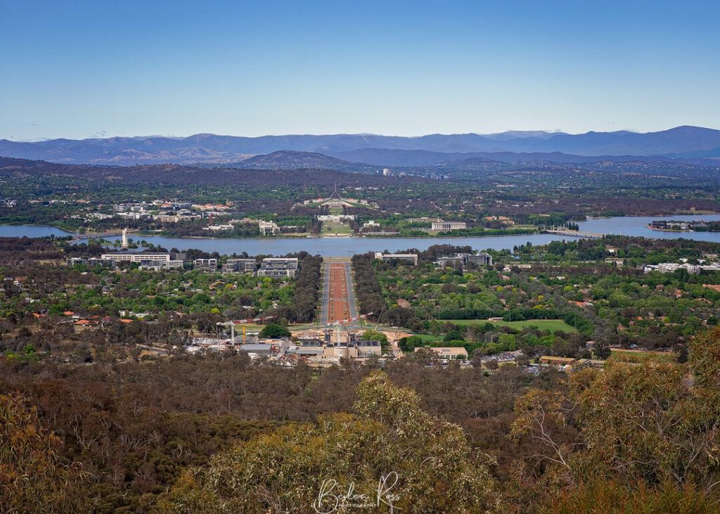
The Best Photography Spots in Canberra
Canberra is a beautiful city with many stunning photography spots offering breathtaking views and landscapes. Some of the best photography spots in Canberra include:
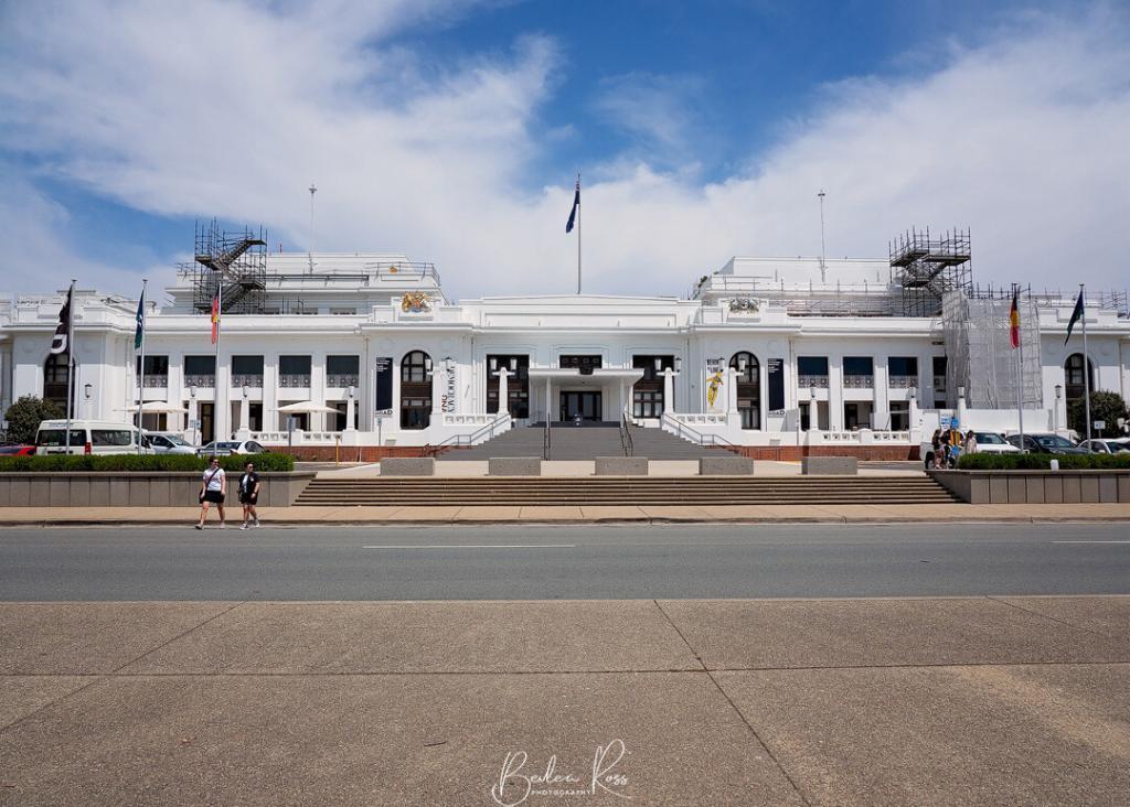
Parliament House
The Australian Federal parliament is housed in an iconic building that forms the centrepiece of the parliamentary triangle. The rooftop of the building is covered in grass and offers stunning views of the city. Designed by architect John Smith Murdoch it was officially opened in 1988, replacing the previous Parliament House.
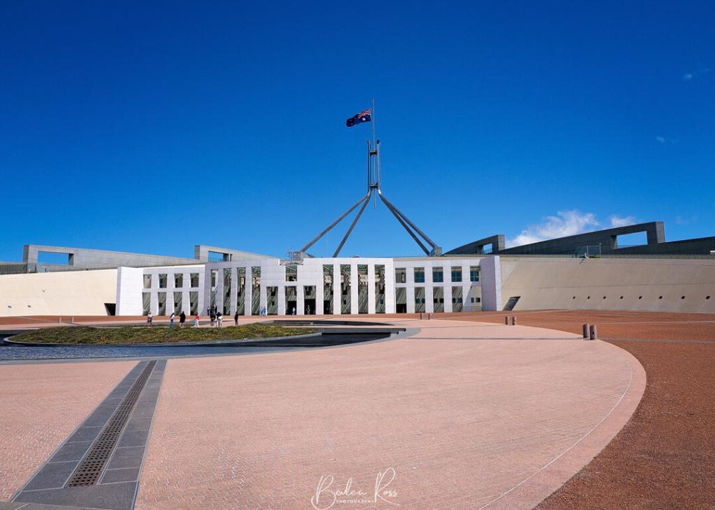
Sitting atop Capital Hill and surrounded by sweeping lawns and gardens, Parliament House is a therefore a grand and modern building made of glass, steel, and concrete. Its large central dome is visible across the city. Visitors are welcome to explore the public spaces inside, including the Great Hall, Members Hall, and the House of Representatives and Senate chambers. Guided tours are also available, offering visitors the opportunity to learn about the building’s history and the workings of the Australian Government.

Parliament House is also home to many important artworks, including paintings, sculptures, and other decorative objects, reflecting the cultural heritage of Australia. Notable artworks on display include artist Frank Oakeshott’s murals and artist John Hancock’s stained-glass windows.
Photo Tip: The reflecting pool in front of the building is best at night or blue hour.
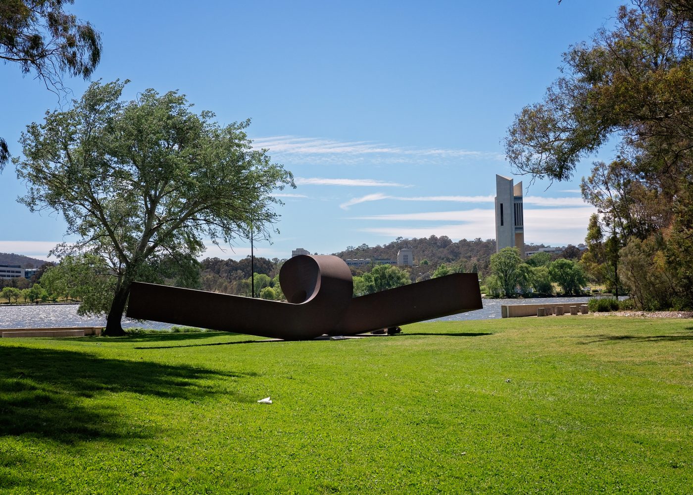
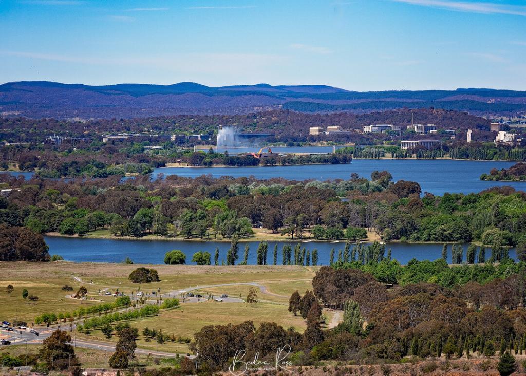
Lake Burley Griffin
The artificial lake in the heart of Canberra was named after Walter Burley Griffin, the American architect who designed the city. The lake was created as a central element of Griffin’s design for the city. For this reason, it remains a defining feature of the Canberra landscape. In addition, the lake offers a range of recreational activities, including boating, fishing, picnicking, and cycling. It is also a popular location for events and festivals throughout the year.
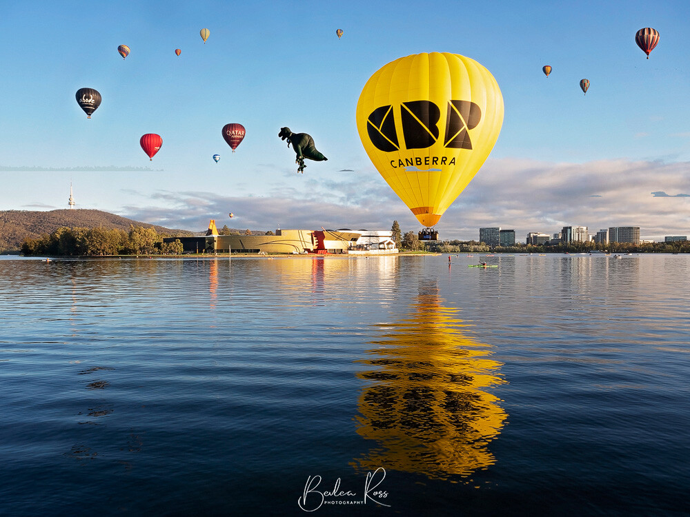
One of the most iconic features of Lake Burley Griffin is the Captain Cook Memorial Jet. This water jet in the lake’s centre shoots up to 147 meters into the air. The jet is particularly spectacular when viewed at night when coloured lights illuminate it. In addition to its recreational activities, Lake Burley Griffin is also an important symbol of Canberra and its history. Additionally, important cultural institutions like the National Museum of Australia, the National Gallery of Australia, and the Parliament House surround the lake, making it a vital part of the city’s cultural and political landscape.
During the Balloon Festival in March each year, the lake on the opposite side to the National Museum is a fabulous location to photograph the balloons taking off and floating across the lake.
Photo Tip: foggy mornings on Lake Burley Griffin make a great photo.
National Gallery of Australia (NGA)
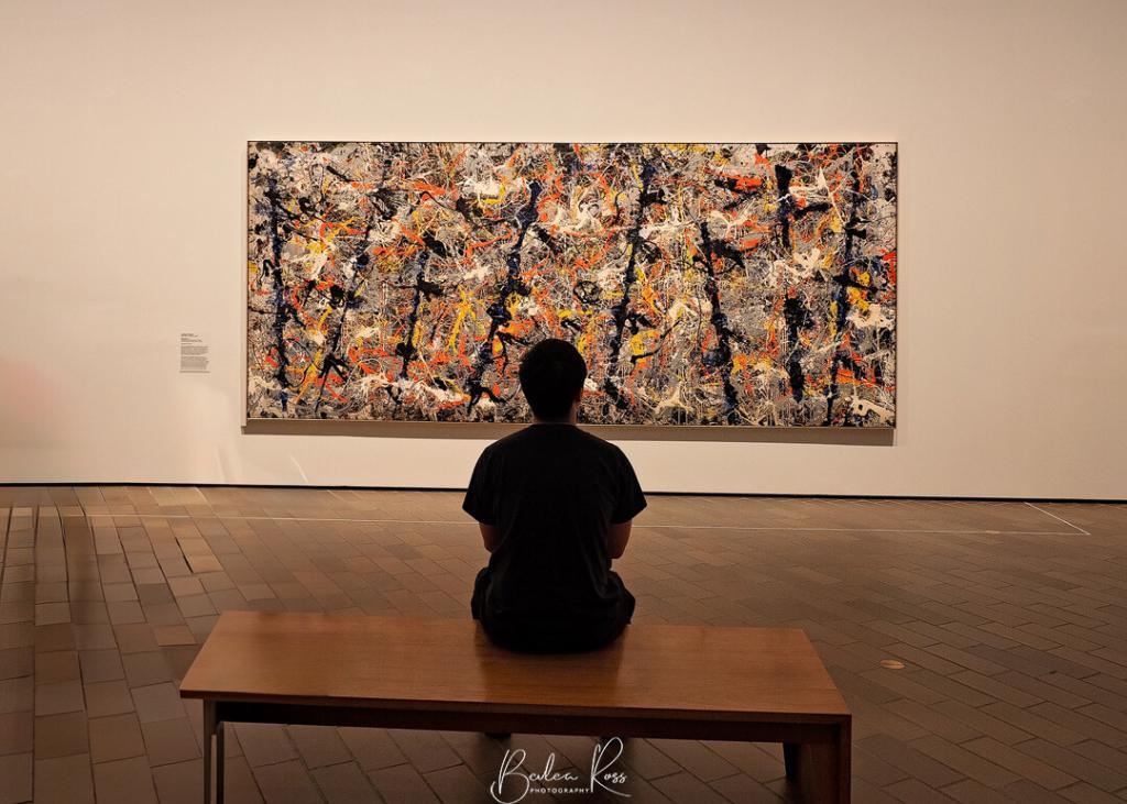
The National Gallery of Australia is a modern building designed by architect James Mather. The NGA opened in 1982 and is the largest art museum in Australia. Within its walls are a collection of over 166,000 works of art from Australia, Asia, Europe, and the Americas.

The collections include many art forms, including painting, sculpture, photography, decorative arts, and works on paper. Some of the museum’s most notable holdings include works by prominent Australian artists such as Tom Roberts, Grace Cossington Smith, and Sidney Nolan. In addition, significant works by international artists such as Vincent van Gogh, Pablo Picasso, and Claude Monet are also on display.
In addition to its collection, the National Gallery of Australia offers a range of educational programs. These include guided tours as well as workshops, and events, making it a valuable resource for schools and educational institutions. A visit to the sculpture garden is not to be missed. The building features spacious galleries, a library, a café, and a rooftop restaurant. It’s not hard to see why the NGA is a popular destination for art lovers and visitors of all ages.
Photo Tip: visit Fujiko’ Nakaya’s Foggy Wake In The Desert ecosphere, which operates from 12.30 – 2 pm daily
Mount Ainslie
Mount Ainslie’s summit is a well-known attraction for both visitors and residents, providing stunning views of the city and surrounding areas. As a part of the Canberra Nature Park, it’s home to diverse flora and fauna, including eucalyptus trees, native shrubs, and various bird species. The location offers walking paths, picnic areas, and observation points, making it an ideal destination for outdoor enthusiasts looking to hike, birdwatch, or enjoy a leisurely picnic.
Mount Ainslie offers visitors two options to reach its summit – a scenic drive or a hike through the mountain’s natural bushland. The trails leading to the top provide a picturesque view of Canberra and its surrounding landscapes which include Parliament House, Lake Burley Griffin, and the Australian Alps. The summit of Mount Ainslie provides breathtaking panoramic views of the city and its surroundings, making it a must-visit destination for anyone traveling to Canberra.
Australian War Memorial (AWM)
The memorial’s stunning architecture and location on a hill overlooking the city make it a popular spot for photographers. The Australian war memorial was established to commemorate the service and sacrifice of the members of the Australian armed forces and to honour the sacrifices of all Australians who have served in wars, conflicts, and peacekeeping operations throughout the country’s history.

The building was designed by the architect John Castles and was completed in 1941. It is considered one of the most significant war memorials in the world. The memorial features a shrine room where visitors can pay their respects to the fallen. The museum also houses a collection of artefacts, documents, and artwork related to Australia’s military history.
The museum’s exhibitions showcase the Australian military’s experiences and the war’s impact on the country and its people. Visitors can also view weapons, uniforms, medals, personal letters, interactive displays, and multimedia presentations. These bring the history of the Australian military to life. In addition to its exhibitions, the AWM also offers a range of educational programs, guided tours, workshops, and events. These provide a valuable resource for schools and educational institutions.
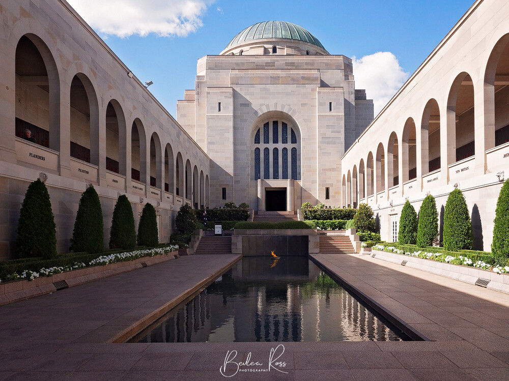
Photo Tip: The reflecting pool on a still day and the wall of poppies make great images.
Old Parliament House
This historic building was the seat of the federal Government from 1927 to 1988 and was designed by the architect John Smith Murdoch. It was officially opened on May 9, 1927, by the Duke of York (later King George VI). The building was initially intended to be a temporary structure. However, it served as the federal Government’s home for over 60 years. The Old Parliament House was the site of many important political and social events. These included opening the first federal parliament and swearing-in of Australia’s first prime minister, Edmund Barton.
The Old Parliament House was replaced by the New Parliament House in 1988. It has, however, been preserved and renovated as a museum known as the Museum of Australian Democracy. The museum showcases the history and significance of the Old Parliament House offering visitors a unique insight into Australia’s political and social history. Visitors can explore the historic building and its exhibitions, including the House of Representatives and Senate chambers, the Prime Minister’s Office, and the King’s Hall.
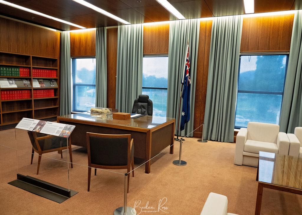
The museum also offers a range of educational programs and activities, including guided tours, interactive exhibitions, and special events. In addition, its beautiful gardens and architecture make it a popular spot for photography.
National Museum of Australia
Located in the heart of Canberra, the building is considered an iconic piece of architecture. Designed by the architect firm Ashton Raggatt McDougall (ARM), it was completed in 2001. It has received several awards and accolades for its design. The Australian landscape inspires the building’s design and reflects the country’s natural beauty and cultural heritage.

The museum’s façade is characterised by its curved roofline and the use of natural materials such as timber and stone, which blend harmoniously with the surrounding landscape. The central atrium provides a dramatic entrance to the museum, with its soaring glass walls and natural light creating a welcoming and spacious atmosphere. The museum’s exhibitions are housed in a series of interconnected galleries, each with its unique character and atmosphere.
Ovolo Nishi Grand Staircase
Ovolo Nishi is a luxury hotel in Canberra, Australia, known for its unique and innovative design. One of the hotel’s standout features is its Grand Stair. This large, sweeping staircase serves as the main entrance to the building.
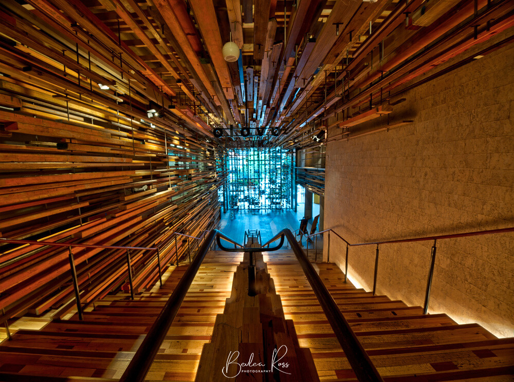
The Grand Stair is a stunning architectural feature that spans three floors and provides access to the hotel’s main lobby and guest rooms. The concrete stairs feature a striking, cantilevered design that appears to float in mid-air. The treads are lit from below, creating a warm and inviting atmosphere that welcomes visitors to the hotel. In addition to its functional purpose, the Grand Stair also serves as an art installation in its own right.
The National Arboretum
The arboretum covers an area of over 250 hectares. Significantly, it is home to a diverse collection of over 94,000 trees and shrubs representing over 100 countries worldwide. Established in the aftermath of the 2003 bushfires that swept through the region, its mission is to promote the conservation and protection of Australia’s forest heritage. The National Arboretum also features several other attractions, including the forest sculpture gallery, picnic areas, walking trails, and scenic lookouts.
The aboretum is still growing with most of the trees not yet mature. While the views are great, the trees arent much to look at save for in autumn. The Village Centre in the Arboretum houses a cafe, gift shop, and exhibition spaces. This makes it a great place to start or finish your visit to the National Arboretum.
National Zoo and Aquarium
The zoo houses various animals worldwide. Animals include but are not limited to:
- Big Cats: lions, tigers, and Jaguars
- Primates: gorillas, chimpanzees, and orangutans
- Marsupials: kangaroos, wallabies, and Tasmanian devils
- Birds: parrots, owls, and various species of exotic birds
- Reptiles: snakes, lizards, and turtles
- Aquatic animals: sharks, rays, and multiple species of fish
- Other mammals: meerkats, red pandas, and ring-tailed lemurs

.

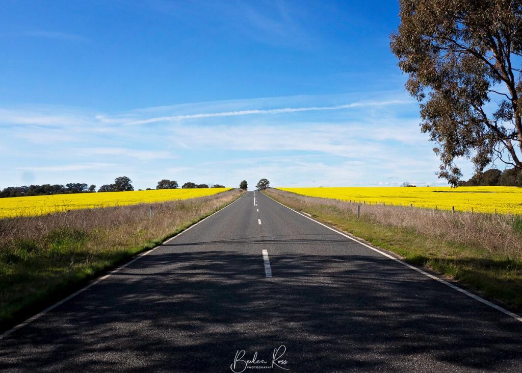
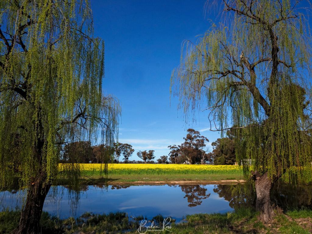
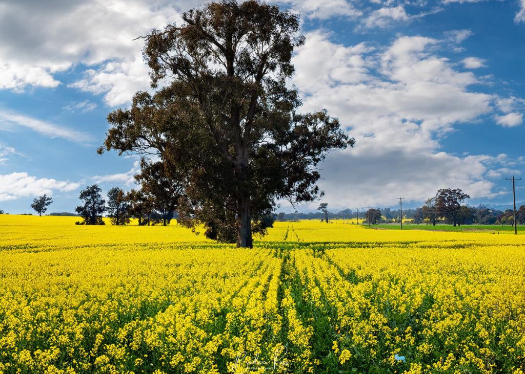
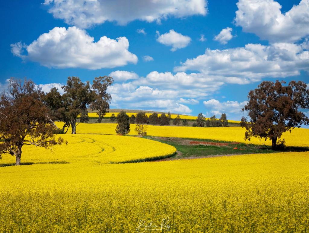
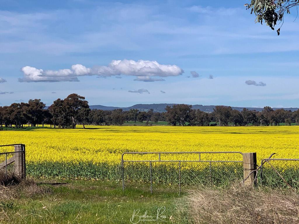
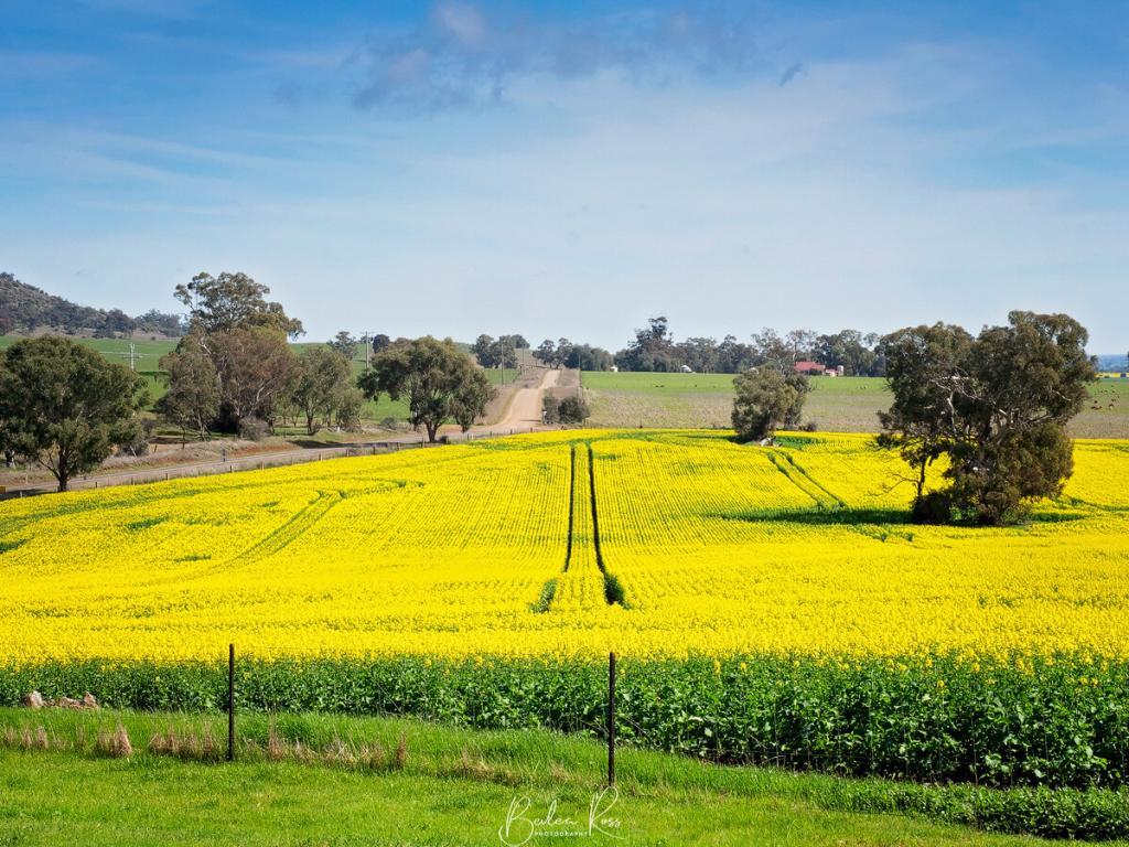
The Goulburn Valley Canola season has begun, signalling the arrival of spring. The fields are bursting with vibrant yellow blooms, creating a stunning display. You can’t miss the beautiful yellow flowers that adorn the countryside when you travel from Melbourne to Ballarat or up to the ski fields. The fields in this region provide breathtaking views, particularly during the flowering season when the landscape is blanketed with these vibrant yellow flowers.

Goulburn Valley Canola Fields
Canola is a popular crop in several regions of Australia. However, canola is particularly prevalent in Victoria in the Goulburn Valley region. This region is well-known for its fertile soil and favourable weather conditions, making it ideal for growing canola and other crops. It’s home to numerous large and small-scale farmers specialising in growing canola. Other popular areas for canola cultivation also include the Murray Valley and the Riverina, which boast plentiful water resources and thriving farming communities, making them ideal locations for canola production.
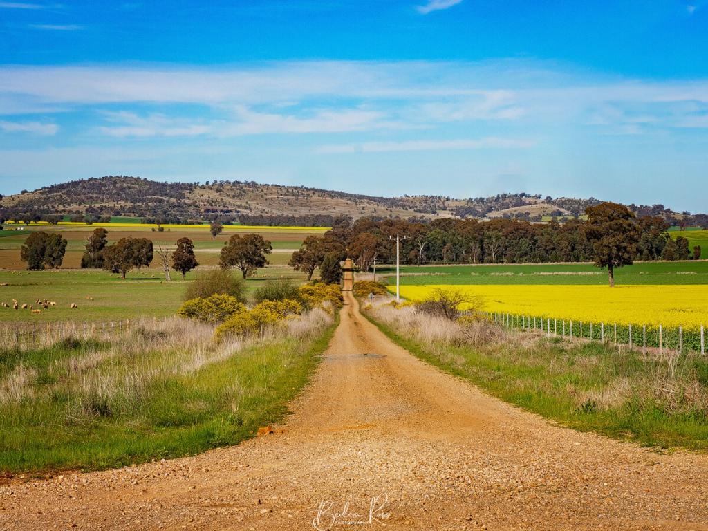
Driving the Goulburn Valley
With a friend visiting me for a few days, we decided to take a mini road trip through the Goulburn Valley to get as many canola fields as possible. Starting in Nagambie (check out the fields in O’Dwyers, Vickers and Nook Roads), we drove to Dookie and had a late breakfast at the Dookie Emporium. It’s a cafe/antique shop, and while the coffee was great, I don’t recommend the food. Or the service. Do yourself a favour and pack a picnic basket!
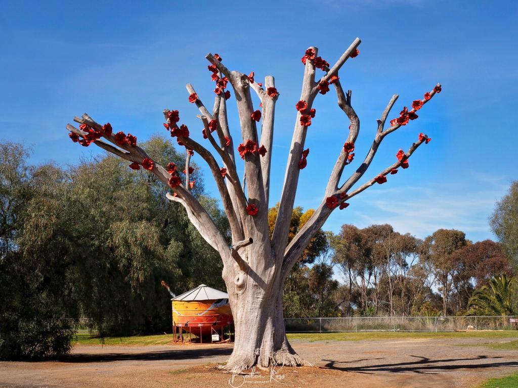
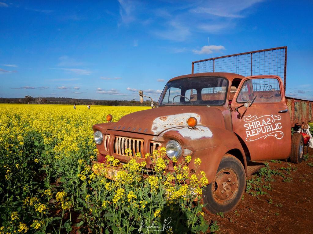
We photographed the Dookie poppy tree (opposite the Dookie Emporium) and a couple of fields near Tallis Winery before heading to Katamatite to check out the new silo, then Pfeiffer Wines and ended our day in Corowa. After breakfast in Corowa the next morning, we headed to Chiltern, then the Shiraz Republic, before returning home.
Goulburn Valley Locations
- Shepparton: A significant agricultural hub surrounded by rich and fertile farmland. This region is particularly popular for canola photography during the flowering season when the fields are ablaze with yellow blooms.
- Nagambie: The charming town of Nagambie is located in the heart of Northern Victoria’s agricultural region. Rolling hills and fertile farmland surround the area. Canola fields provide breathtaking views during the flowering season.
- Dookie: Located 30km from Shepparton is the tiny town of Dookie. Mt Major and Mt Saddleback are prominent landscape features, as are the rich red volcanic soil, historic buildings and other natural features, including a river, creeks and box ironbark forest.
- Shiraz Republic: Situated at 507 Hamblin Road, Cornella, the field is open Friday to Monday, 11 a.m. – 5.30 p.m. The Shiraz Republic is an award-winning winery and cellar door with a large canola field adjoining the Winery/Brewery. This particular canola field permits visitors to walk through it. However, an entry fee of $10 per person is required to enter the Canola Walk. There is no restriction on the duration of your stay, but please be mindful of other photographers. During our visit, a young couple who were taking Instagram photos had monopolised the truck for approximately an hour.

Tips for Canola Photography
Timing: The best time to take breathtaking pictures of Victoria’s canola fields is during their flowering period when they are covered in gorgeous yellow flowers. Although the timing and region depend on weather conditions, you can generally expect the flowering period to start mid-August, be in full bloom by mid-September and finish by mid-October. Additionally, the golden hour – which occurs just before sunrise or just after sunset – is an ideal time to capture striking images of canola fields, as it offers the perfect lighting for photography.
Angle and Perspective: Experiment with different angles and perspectives to capture the scale and beauty of the canola fields. Consider shooting from above or below or using a telephoto lens to focus on individual flowers.
Use of light and shadows: Pay attention to the lighting conditions when taking photos. The overhead sun can be harsh and create unflattering shadows. On the other hand, the side light is softer and can highlight the texture and detail of the canola plants.
Composition: Use leading lines and patterns in the canola fields to create visually appealing compositions. Experiment with different framing techniques, such as the rule of thirds, to make your photos more engaging.
Weather: Inclement weather can add interesting elements to canola photography, such as mist, fog, or rain. Keep an eye on the weather forecast and be ready to take advantage of these opportunities.
Post-processing: Experiment with post-processing techniques to enhance the colours and contrast in your photos. Consider using filters to bring out the yellow tones in the canola flowers.
Just go!
Capturing the beauty of the canola fields in Northern Victoria during the flowering season is a unique and rewarding experience for any photographer. The rolling hills, vast expanses of golden fields, and picturesque countryside provide a stunning backdrop for capturing the essence of this region’s agricultural heritage.
So don’t hesitate; grab your camera and head out to capture the beauty of the canola fields. Whether you’re a seasoned photographer or just starting out, there’s no better way to experience the magic of Northern Victoria’s landscape than through the lens of a camera.
You’re bound to capture visually stunning images with the right preparation, a keen eye for detail, and a little creativity. So go ahead, take the leap, and see what you can capture!

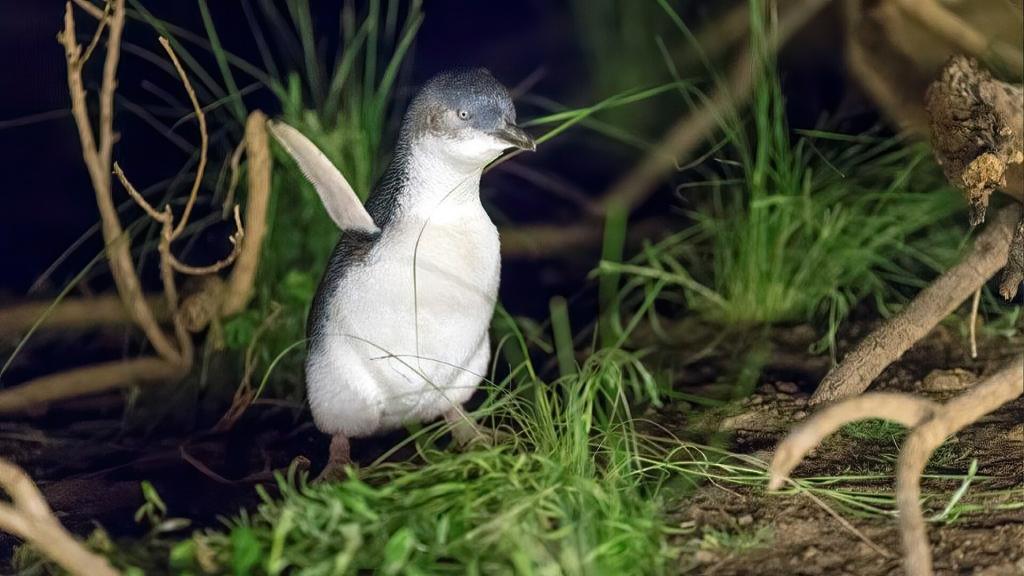
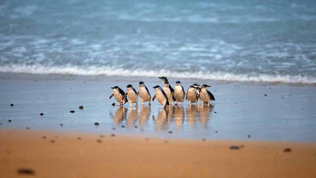
Summerlands at Phillip Island have been the natural habitat of Little Penguins for centuries. During the day, they venture out to catch fish and return to their nests on Phillip Island at the Summerlands Peninsula as night falls. Here, they incubate their eggs, care for their young, and shed their feathers. The spectacular sight of these penguins returning to their homes at sunset has been a popular attraction for over a century.
How it all began
The story of Summerlands Beach and its beloved penguins dates back to the 1920s and three Phillip Island locals, Bert West, Bert Denham, and Bert Watchorn. The three Berts were the first to open the beach for organised penguin viewings. They greeted visitors getting off the ferry and offered personalised tours of Summerlands and Phillip Island for just five shillings a piece. For an extra shilling, you could get strawberries and cream.
In the 1940s, visitor numbers soared when the bridge from the mainland to Phillip Island was erected at San Remo. At this point, tourists began flocking to the pristine shores and started building houses around Summerlands Beach.
Prior to a formal sanctuary, beachgoers would pack their baskets and gear, heading to the shores to witness the enchanting sight of penguins emerging from the water. Although seemingly innocent, this practice took a toll on the penguins’ natural habitats and homes, as the influx of tourists disrupted their daily routines.

Summerlands Estate
During the 1920s, the peninsula was divided into 900 plots of land and named Summerlands Estate. It mainly consisted of exposed land bordered by steep cliffs that dropped into the Bass Strait. In the late 1940s, several families from Melbourne purchased plots and constructed simple fibro holiday homes.
Over time, the number of homes in the area grew to around 177 by the 1980s. However, this growth brought challenges, as dogs and foxes began endangering the penguin population, and road accidents became more frequent. As a result, the local penguin study group became increasingly worried about the declining penguin numbers. They feared the penguin colony wouldn’t survive if something wasn’t done.

More concerning, however, was the danger that the holidaymaker’s canine companions posed to the Little Penguins. The introduction of dogs to the area contributed to a significant drop in their population. Before long, all but one of the colonies on Phillip Island were decimated. Only the Summerlands colony remained. It became clear that a change in public behaviour towards these valuable creatures was necessary to avoid causing more harm.
The Great Govt buy back
In July 1985, the state government, under the leadership of then-premier John Cain, made a groundbreaking decision. After much lobbying and discussions, they decided to purchase the entire Summerlands estate. They would buy back all 774 allotments and transform it into a wildlife reserve for the little penguins. Nevertheless, this decision brought about significant distress. Understandably, the residents of Summerlands were not pleased with this decision as it would end their community.
By 2007 there were just a few holdouts left. The government then compulsorily acquired the final 42 properties. Twenty empty blocks and twenty-two with houses, held by 34 private owners. After a tumultuous period, the buyback program finally ended in 2010, which many attributed to insufficient funding. During this time, the estate’s future was uncertain, and residents could not work on their properties, much to their dissatisfaction. After the completion of the buyback, all the houses were demolished or removed. The government then spent $3.4 million on a habit restoration program. They continue to install and maintain nesting boxes as well as pest control (eliminate foxes, feral cats and rabbits).
the Little (fairy) Penguins
Little penguins, also known as fairy penguins or Little Blue Penguins, are aptly named due to their small size, weighing just under a kilogram and being slightly larger than a bowling pin. They are the smallest among the 18 penguin species worldwide, and their blue and white feathers are unique to their kind. Along the coastlines of southern Australia and New Zealand, you can find little penguins. However, the largest colony and the last one located on Phillip Island is on Summerland Peninsula, with an impressive 40,000 breeding penguins.
A win for the penguins
The buyback initiative has been deemed a significant victory for conservationists. It immediately resulted in a notable reduction in penguin fatalities from road or dog accidents. In the past, the penguin population was estimated to be between 12,000 to 14,000 in 1984. Fast forward to today, and it currently stands at approximately 40,000 breeding penguins. The region’s preservation has also positively affected other creatures, such as Short-tailed Shearwaters (aka mutton birds).

In another clash of progress and wildlife, the short-tailed Shearwaters are known to flock to the San Remo bridge lights during their migration. Therefore the bridge lights are switched off for a few nights around April 25 during the departure peak. Signs at either end of the bridge warn drivers of the changed traffic conditions.
Another win for conservation at Phillip Island has seen the recent release of the endangered Eastern barred bandicoot.

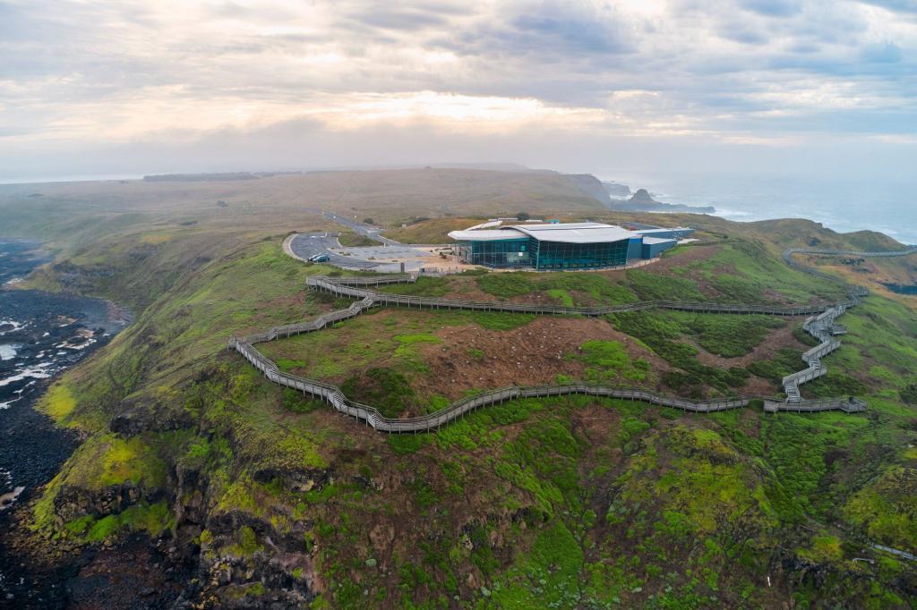
Facilities Today
At the main penguin viewing area, visitors can enjoy a 180-degree elevated platform that overlooks the coast. The penguins usually spend their day in the ocean hunting for food, so they only swim up to rest for the night. Returning at sunset from a long day of fishing, the penguins make their way up the beach to their burrows. The penguin parade platform is right along the sandy shore, offering guests a front-row seat as the penguins waddle up the sand.
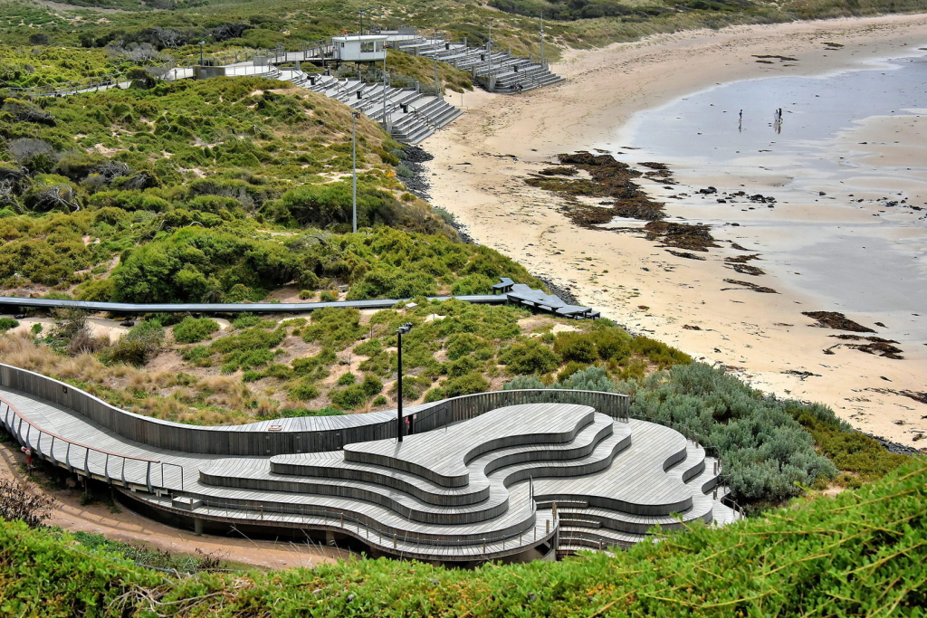
There are ‘levels’ for those wishing to purchase tickets, with the top tier ticket being in the underground viewing section. This allows eye-level viewing of the penguins as they come ashore and the comfort of being inside, out of the weather. It does get freezing on the beach at night.
The Phillip Island Nature Park is one of the best eco-tourism facilities in the world, balancing scientific research and conservation with visitor education and unique wildlife experiences.
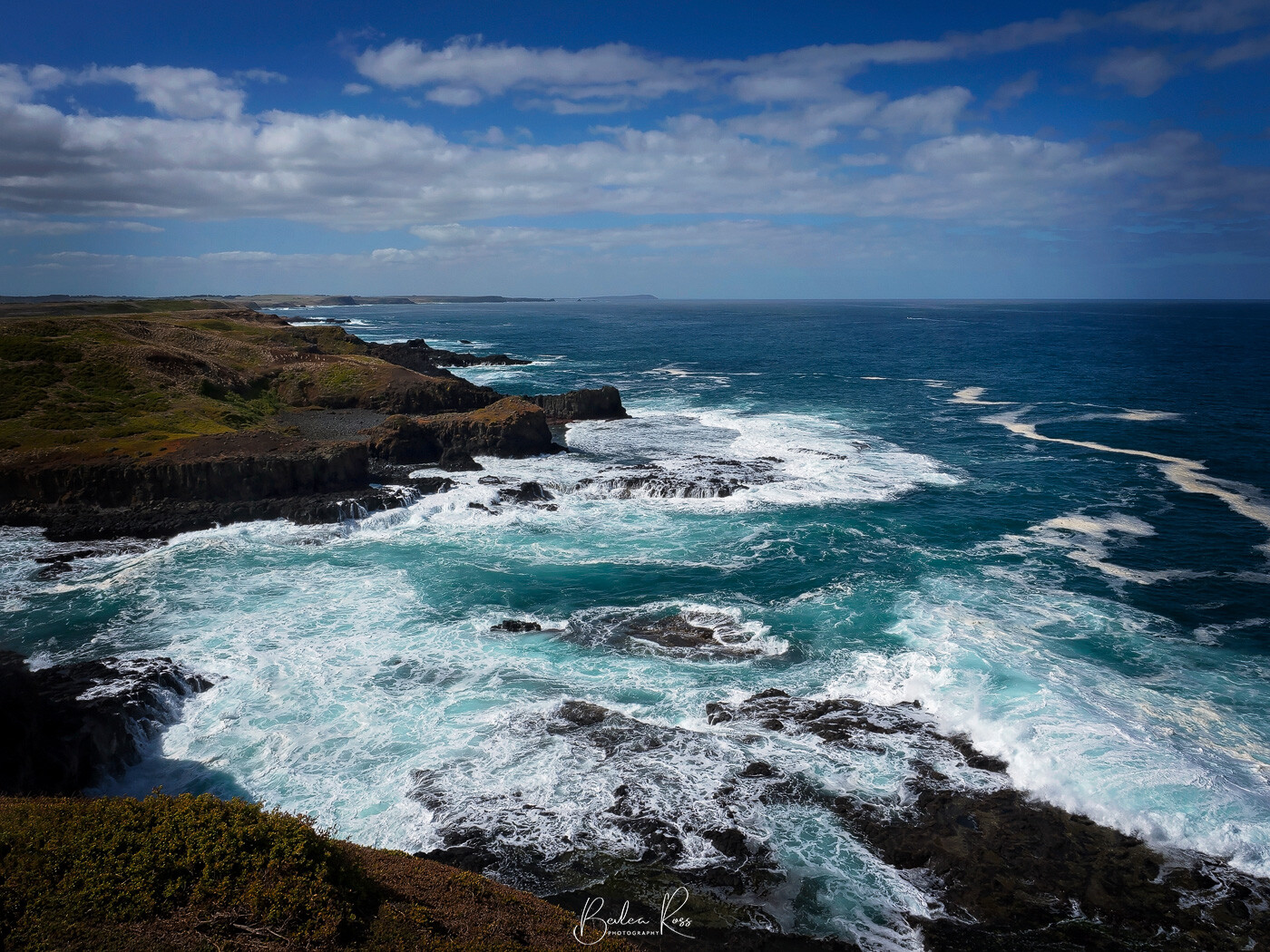
Renowned for its breathtaking landscapes and diverse wildlife, The Nobbies on Phillip Island is one of Victoria’s must visit spots. This area abounds in natural wonders, vibrant sea creatures, and pristine allure.
Located on the southwestern coast of Phillip Island in Victoria, The Nobbies is a popular tourist destination that offers a breathtaking view of Bass Strait.

Geological Marvel
The Nobbies is a remarkable headland that displays awe-inspiring views from the clifftops. Its stunning rock formations result from millions of years of natural forces at work. The area comprises basalt formations shaped by the relentless pounding of the Southern Ocean, creating a mesmerising landscape of sea cliffs, caves, and rock stacks. This geological wonderland attracts visitors from all around the world who come to marvel at its stunning natural beauty.
Marine Life Extravaganza
The Nobbies is more than just a geological wonder. It also boasts a thriving marine ecosystem with various plants and animals. The chilly waters surrounding the headland offer an ideal home for seals, penguins, and many seabirds. Likewise, nearby Seal Rocks are home to a sizable population of Australian fur seals, which delight visitors with their playful behaviour and elegant dives. These charming creatures enhance The Nobbies’ appeal and emphasise the island’s important role in safeguarding marine biodiversity.
Penguin Parade
The Penguin Parade at The Nobbies is a significant draw for visitors. It’s an incredible sight at sunset as the hundreds of tiny penguins return to their burrows on Summerland Beach. Specially built viewing platforms allow visitors to watch these charming creatures waddle onto the shore after a day of hunting in the sea. This daily spectacle serves as a valuable educational experience, highlighting the importance of preserving the natural habitats of these vulnerable seabirds.
Please note that there is an entry fee for attending the penguin parade, and photography is prohibited. The reason provided for this rule is to avoid disturbing the birds, although some may argue that this is an exaggerated claim. Especially in light of there being numerous locations worldwide where penguins can be photographed without any negative impact on their well-being.
Conservation Efforts
The Nobbies and surrounding areas hold great ecological significance, and various conservation initiatives have been taken to protect and preserve this remarkable ecosystem. Parks Victoria has collaborated with local authorities and environmental organizations to implement strict regulations for site management. These measures include visitor guidelines, habitat restoration projects, and ongoing research to monitor the marine environment’s health. Phillip Island aims to balance tourism with conservation to maintain the delicate equilibrium between human enjoyment and preserving its natural treasures.
Fast Facts
- Entry toThe Nobbies is free
- Distance/Time – 800 metres return / 20 minutes return
- The easy, primarily flat timber boardwalk around the headland; however, the lower section has steps
- Ample parking at Nobbies Centre (sealed) car park
- Designated Accessible Parking and toilets available
- Suitable for Wheelchairs for approx first 800m of timber boardwalk in the upper-level Pram friendly
- Bicycles and Dogs not permitted

The state of Victoria, located in southeastern Australia, is known for its varied ecosystems and exceptional wildlife. One of its remarkable inhabitants is the Eastern Barred Bandicoot (Perameles gunnii), a small marsupial species believed to have been extinct in mainland Australia since 1991. Recently, however, it has become the first Australian species to have its conservation status revised.
Characteristics and Habitat:
The Eastern Barred Bandicoot is a small, stout marsupial that measures about 30 centimetres in length and weighs roughly one kilogram. Their distinct features include short, round ears and a pointed snout, while their fur colour ranges from sandy brown to grey, with white undersides and pale bars on their hindquarters, giving them their name.
Historically, Eastern Barred Bandicoots inhabited many grassland habitats across southeastern Australia, including Victoria. They primarily occupied the grassy woodlands, tussock grasslands, and open grassy plains that were once abundant in the state. These habitats provided ideal conditions for foraging on insects, spiders, plant tubers, and roots, which comprise most of their diet.

- When they dig for food, they create funnel-shaped holes.
- Under favourable conditions, they can produce up to five litters per year.
- Are pregnant for only 12 days before giving birth
- As omnivores, they have a diverse diet that includes invertebrates, plants, fungi, and fruit.
- On average, they weigh 800g and can measure up to 40cm in length, tail included.
Back from the Brink of Extinction:
Over the past century, the population of Eastern Barred Bandicoots has experienced a dramatic decline due to various factors. Agricultural and urban development activities have caused significant land clearance, which has resulted in damage and fragmentation of their natural habitat. This, in turn, has led to the loss of food sources for the bandicoots. Thus leaving them more susceptible to predators like foxes and feral cats. The number of these creatures dwindled to approximately 150 in a single area near Hamilton until conservation groups and government agencies created the Eastern Barred Bandicoot Recovery Team in 1988.
Conservation Efforts:
Recognising the urgent need to protect this unique species, dedicated conservation efforts have been undertaken in Victoria. Conservation organisations, government agencies, and local communities have collaborated to implement various initiatives to safeguard the Eastern Barred Bandicoot.

The eastern barred bandicoot remains on the endangered species list. However, new populations are thriving after successful breeding and release programs. One of the primary strategies has been the establishment of predator-free enclosures, also known as “safe havens.” These fenced areas protect them from introduced predators such as foxes or feral cats, allowing bandicoot populations to recover and breed in a controlled environment. The enclosures at Skipton and Dunkeld are carefully managed to ensure the bandicoots can access suitable habitats and sufficient resources. It is estimated that around 1,500 bandicoots live at these protected reserves in Victoria.
The third and final release of fifty-six bandicoots occurred on French Island in 2019. With no deaths reported, another eighteen were released.
Bandicoot Bodyguards
The bandicoot trials were planned in 2015, inspired by the success of the Middle Island penguin project depicted in the film “Oddball”. Maremmas were introduced to protect penguins from foxes, and it was hoped that they would also effectively safeguard bandicoots. Significantly, it was found that the bandicoots were not overly concerned by the presence of the dogs.
The challenge was that bandicoots are solitary and only active at night. On the other hand, the Maremma dogs are social animals that seek companionship. To overcome this challenge, a small flock of sheep was brought in as a potential solution. The idea is that the maremmas would focus on the sheep during the day and the bandicoots at night when the sheep are resting, thus meeting the dog’s social needs while protecting the bandicoots.
Currently, the Eastern barred bandicoots can only be found in two specific locations in mainland Australia, both enclosed by predator-proof fences. These sites are the only places where the bandicoots can live outside of captivity. Before this, the bandicoots were only found in the wild on multiple islands, such as Churchill and Phillip, where they were introduced to protect their species from extinction.
Importance of Conservation:
Preserving the Eastern Barred Bandicoot for Victoria’s biodiversity and ecological equilibrium is crucial. Being an endemic species, it serves a significant purpose in sustaining healthy ecosystems by dispersing seeds and regulating insect populations. Additionally, the bandicoot’s existence reflects Victoria’s grassland habitats’ overall health and wellness.
Efforts to conserve the Eastern Barred Bandicoot go beyond just protecting the species itself. These initiatives also play a role in preserving the habitats of other native wildlife and restoring the ecosystem services they provide. The conservation of the bandicoot is closely linked to larger environmental objectives such as preventing species extinction, safeguarding biodiversity, and promoting ecological resilience.