Tag:victoria

Our plan was Phillip Island & San Remo and for the weekend. Phillip Island is only around 2 hours from home, and while we had been there before, it had been a few years. So we decided to head back this easter break. We started our photography plans with a drive along The Blvd. You can walk it, but we decided to drive it. This was because there is only one place you can stop along the way with a small lookout. Parking is not allowed on the verges. It’s supposed to be one way as it’s too narrow for cars to pass each other on many parts of the road. Not that it stopped some young idiots in a convertible coming from the opposite direction. You access it by driving to the Nobbies visitor centre. From there, you take the road off to the left as you approach the carpark.

There are some fabulous views along the way. We spotted a hovering Kestral that I tried to get a shot off. However, he was too far offshore and dived before I could get a picture every time. The only time he came close was so close that I couldn’t get a shot, either. Because the long lens wouldn’t focus – he was TOO close!

We booked a lovely house in San Remo for our stay as our main photographic goal was to shoot Cadillac Canyon – and the house was only 5 mins drive from there. Cadillac Canyon is accessed from Potters Hill Road.. from the carpark at the end, it’s a short walk to the start of the stairs down to the beach, 138 steps in total but nice wide, solid wooden steps with lots of landings along the way — they need a seat at the halfway point! 😉

Panhandle Flats
Once you are on the beach, Panhandle Flats is off to the left. To the right, at the other end of the beach, is Cadillac Canyon. We first went down there looking for a sunset, and while the light was excellent, the sunset wasn’t happening. The tide also made getting out onto Panhandle a no-go. So we decided to come back again in the morning.

The weekend daylight saving had finished in Victoria, so sunrise moved from 7.09 am to 6.09 am. We were up at 5 am – coffee and out the door arriving at the beach in the dark. Even though it was still dark, a car was already in the carpark before us. It turned out to be a surf fisherman. It had been a full moon the night before. So torches weren’t needed with the moonlighting our way down the steps and across the beach to Panhandle Flats. Tide was also with us. At 6.22 am, we could get out on the flats and set up with the low tide.
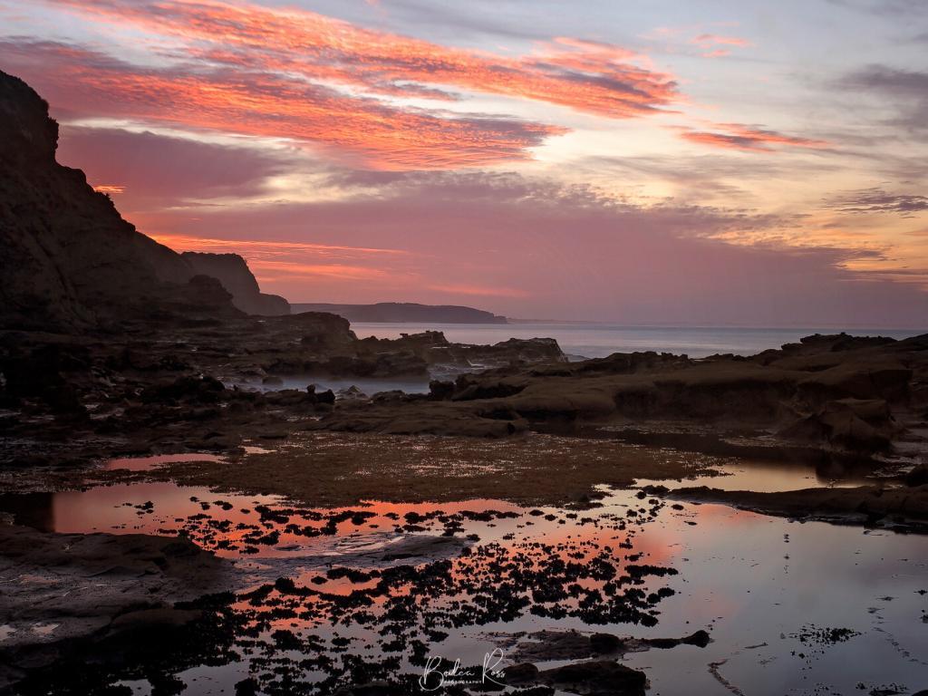
The colours in the sky didn’t look that promising. But just before sunrise, the sky popped a glorious red for a few minutes. We got our shots quickly because it was very short-lived.

Once the sun was up, we moved across to Cadillac Canyon. Apart from two surf fishermen, we had the beach totally to ourselves.

Pelicans
By now, it was just after 8 am, and we were starving. So we headed back to the house for breakfast and a rest before heading into San Remo to watch the pelican feeding at the pier. The feeding is free, though they have a collection tin for donations. Feeding takes place every day at midday outside the fishing co-op.

The birds are not worried about the humans. We were roped off from the feeding area (not sure for whose protection, lol). One late pelican arrival just barged into the throng of people, pushing his way through the spectators to get to the feeding area.

Pyramid Rock
Later that afternoon, we headed to Pyramid Rock on Phillip Island. It would be a good sunset spot – and is on our list for next time. The walk to Pyramid from the carpark is an easy 800m return. It has only a slight elevation; even with tired legs from the morning’s stairs, we cruised it in.


We had a fabulous weekend at Phillip Island & San Remo and hope to go back again in the summer months.

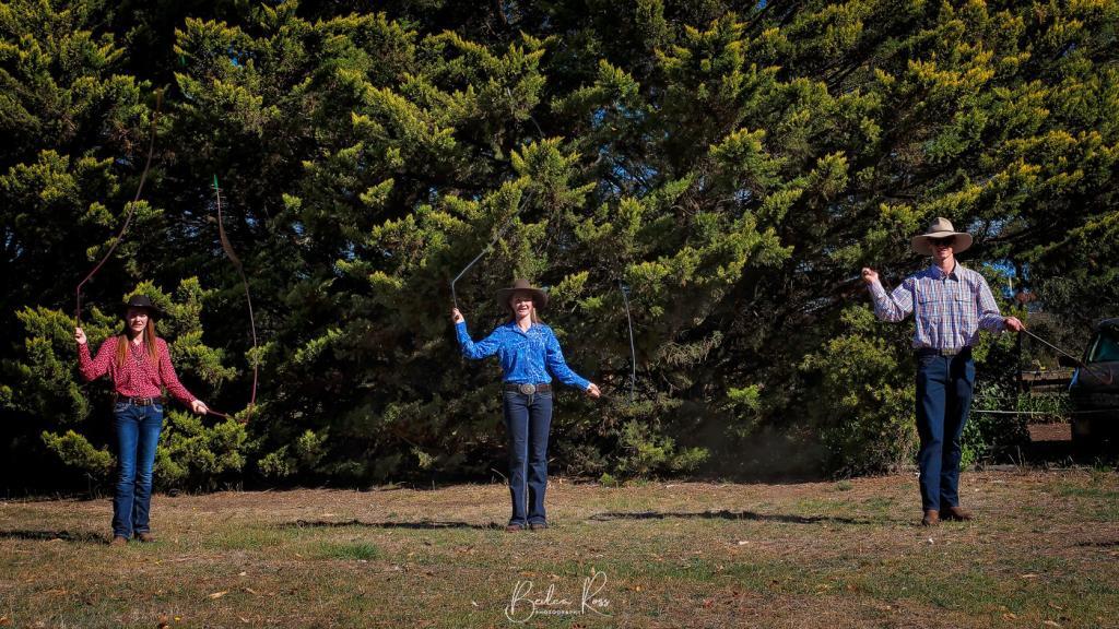
I knew whip-cracking existed. I’ve seen movies. However, I never really thought about it. Or considered it still an art practised today, especially a competitive one. But due to a demonstration by three very talented young whip-cracking wonders I am now educated.
Whip Cracking Competitors
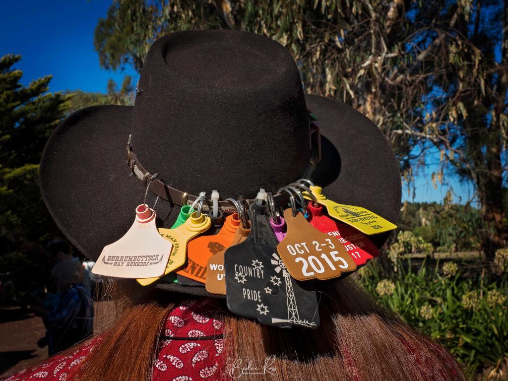
Led by Madi Buzza and assisted by sister Keira and close friend Cody, our group was treated to an hour of their whip cracking skills. The trio also travels around Australia, attending festivals and competitions or demoing and teaching. Madi’s hat was evidence of this. It’s a virtual ‘map’ of her travels as a contestant.

West Side Whipcrackers
Nineteen-year-old Madi has been whip cracking for five years. Younger sister Keira, at 15 yrs old, has been cracking for four years. Cody became the third member of their little group. The trio became firm friends after meeting at an event last year. Sixteen-year-old Cody has been cracking for 12 months. The three are members of West Side Whip Crackers, a branch of the Australian Whipcrackers and Plaiters Association.


Stop off at the Deniliquin Ute Muster if you are up Deniliquin way in September. The Whip Cracking Wonders will be competing there at the NSW Whipcracking titles. It’s well worth seeing!

Wilsons Promontory National Park, or ‘The Prom’, as it’s affectionately known, is the southernmost point of mainland Australia. It’s also a top-rated destination. It has stunning coastal scenery, pristine wilderness, massive granite mountains, open forests, rainforests, sweeping beaches, and abundant native wildlife. It serves to make Wilsons Prom a photographer and holiday delight.
Accom at the Prom
Accommodation ranges from camping, and caravans to huts, cabins, and lodges. The prom has become so popular in recent years that it has its own manned police station in the summer months at Tidal River. It’s a far cry from my first visit 35 yrs ago. There were no amenities for campers save for a lonely toilet block back then.

Yanakie
We stayed in Yanakie just outside ‘The Prom’ on this visit. The main reason is that the caravan park was right on Corner Inlet. So if the weather gods were kind to us, we could get sunrise right outside our cabins without leaving the park. Some of our group took that to heart and came out to shoot the sunrise in jammies, only a few feet from the cabins. Why get dressed? 🙂
The weather gods did indeed smile on us. We had a magical sunrise on Saturday morning from blue hour, red skies and golden hour.


Tidal River
After a hearty breakfast cooked in our cabins or the bush kitchen for those camping, we headed into the park and made our way to Tidal River. Following the sunrise, it had rained, but the sun was now out, and we had stunning blue skies (prom weather is highly changeable) The temp climbed to around 30C. We were all melting. sun hats, sunnies and find shade became the order of the day


By the time we got back to the general store for lunch, the weather had turned again. The temp had dropped around 10°, and we were all reaching for the jackets we discarded earlier.
Squeaky Beach
After lunch, we headed to Squeaky Beach, so named as the fine sand squeaks when you walk on it. By now, the weather had indeed turned, and a storm threatened, so our time was limited. Nevertheless, the sand had a fabulous array of colours, and little streams led across the sand to the water.

We stopped off at Picnic Bay lookout – didn’t do the walk as it looked too long with the skies threatening.


Agnes Falls
The weather wasn’t kind for either sunset or sunrise the following day. However, we decided to call in at Agnes Falls on home from Wilsons Promontory. Considering it was the end of summer, the amount of water flowing over the top wasn’t too bad.

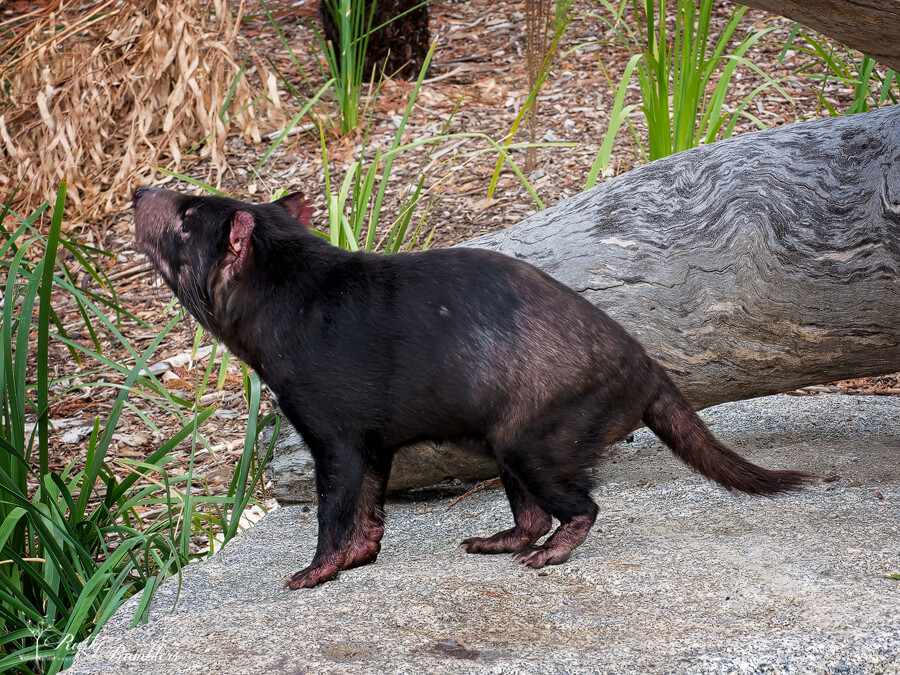
In December 2017, Melbourne Zoo opened a new exhibit – the Carnivores Trail. The new enclosure houses the Lions, Sumatran Tiger, Tasmanian Devil, African Painted Dog and Snow Leopard. I had been to the zoo many times and failed to get a ‘shot’ of the tiger. He always seemed to be hiding at the back of his old enclosure, so I decided another trip was in order.
the Carnivores Trail
On the day we visited, the Lions weren’t on display as they were adding new tree trunks for them to climb on. Considering we visited in February and the ‘Trail’ had only been opened for around seven weeks, it was disappointing and poor planning on the zoo’s part. Another disappointment was that the trail wasn’t circular like the map at the entrance. Once past the invisible snow leopards, the trail was blocked, and a sign told us to retrace our steps. So while the trail was open to the public, it seems that it’s certainly not finished.
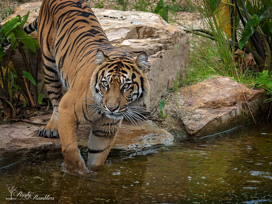
Snow Leopards and tigers
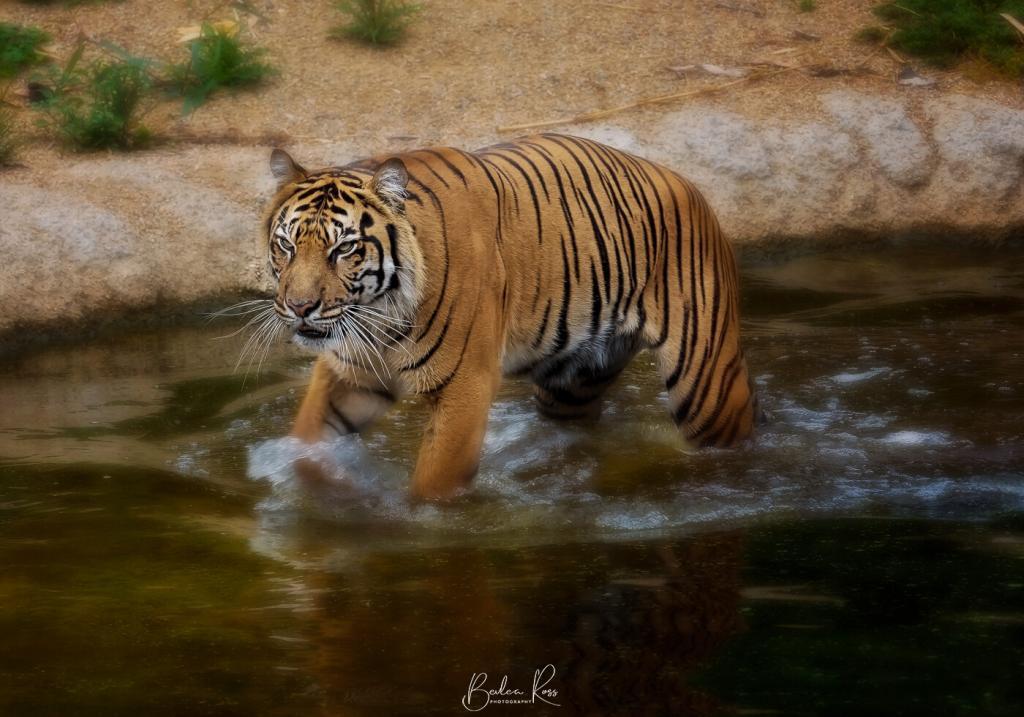
The snow leopards have mythical status as they are hard to find. When we visited again, they were nowhere in sight. A fellow photographer had visited five times since the opening of the new trail and had not seen them once. The new Tiger enclosure is excellent. We were lucky to see him wading back and forth in the water for a good ten minutes.
Lemur Island
From the Carnivores Trail, we headed off to Lemur Island. Not actually an island but a fully enclosed walk-through exhibit where the Ring-Tailed Lemurs swan around relaxing and observing the visitors…


Gorilla Rainforest
Lemur Island leads to the Gorilla Rainforest. Among the Western Lowland Gorilla and other animals, it’s also home to the tree-tops apes and monkeys.


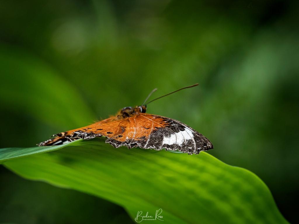
Butterfly House
We headed to the Butterfly House from the Gorilla Rainforest. This is one of my favourite exhibits at the zoo. It’s home to hundreds of butterflies fluttering around and landing on people.


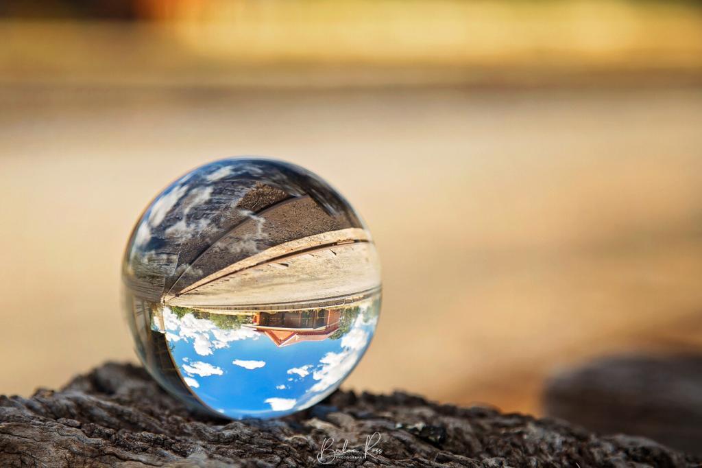
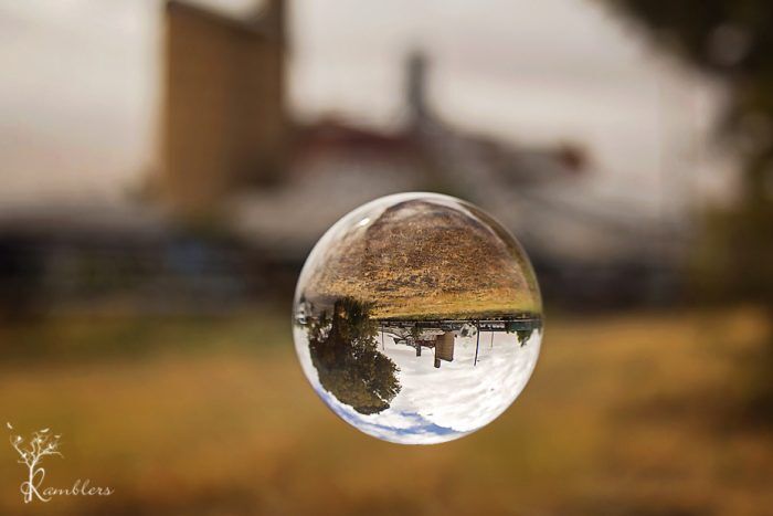
Crystal Ball photography has become extremely popular, but how to do crystal ball photography or where to start?. Due to the shape of the ball, it’s refractive – meaning anything viewed through it is reversed, and it gives you a fish eye effect without a fish eye lens.
Crystal balls come in several sizes from 40mm to 110mm and are readily and cheaply available on eBay (though I have seen a 200mm!) While they are referred to as crystal balls, most are actually glass. The ball in these images is a glass 80mm. While the bigger sizes are easier to photograph and fill more of the scene, their weight is considerable. I have a 40mm on the way… it will be much lighter, but the trade-off is what I can shoot. I’ve also dropped my 100mm or had it roll off a surface a couple of times, so it now has a couple of tiny dings in it, so I also have a 110mm on the way too.

Photographing the Ball
To have your crystal ball stand out from the background, you need a wide aperture – F4 or lower. Stand back from it and zoom in to get the soft, blurred out background. The image above was shot at F4, 105mm, and about 4 feet away. Duck down, so you are looking straight onto it or lower. Don’t shoot from above, as you will only get what it’s sitting on. Instead, focus on the main point of interest in the ball and shoot your image. Out of direct sunlight is best to avoid reflection (see the top right where the sun hit it on the ball above).
Positioning the Ball
To place the ball, you can either put it on a pole, a flat surface, in a shot glass, or water. (I’m going to try a golf tee next!). Location wise you need something interesting behind it. Place the ball and move your feet until you have a pleasing composition. It all depends on the angle. Keep a lint-free cloth handy to clean it between shots, or wear cotton gloves to keep the fingerprints off. Then shoot and have fun.
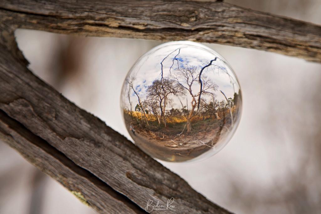
Rightside Up or Upside Down?
Because of the refractive aspect, your images are always upside down when shot… but you can flip them right side up using your editing program. For example, to get the shot of the wetlands below, we wedged the ball into the fork of a tree…. and then I flipped the image in Photoshop so it was right side up.
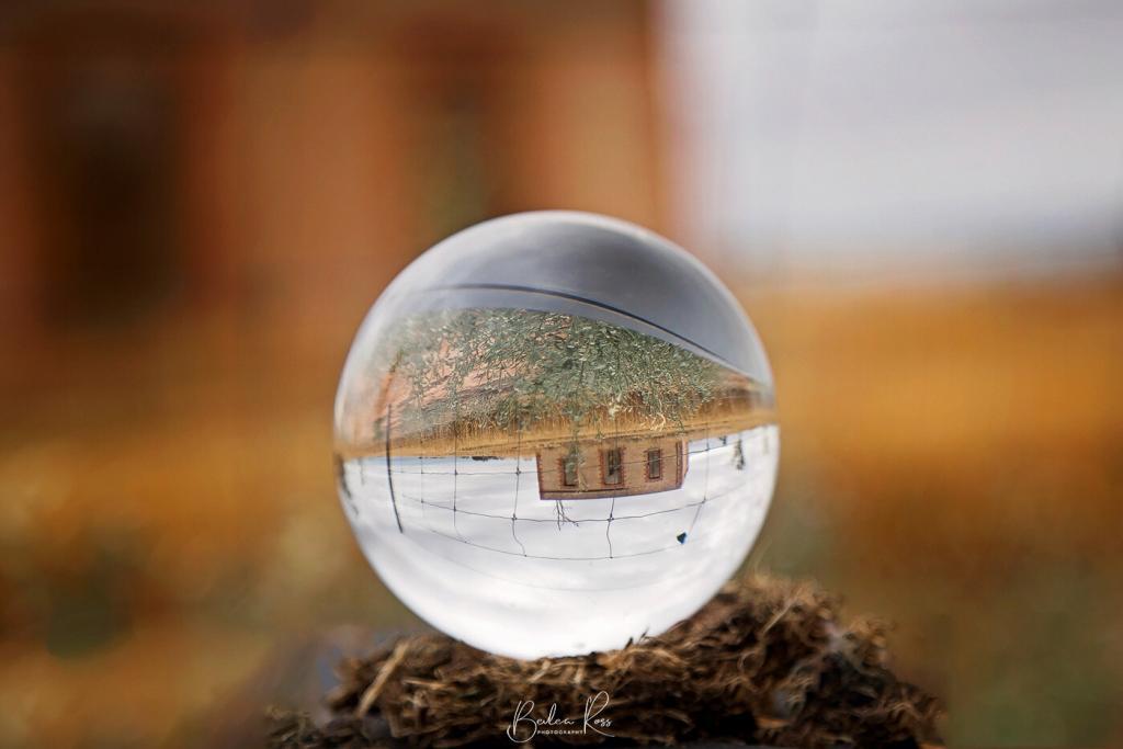
Floating?
I wanted to get a shot that looked like the ball was floating/hovering in the air. So I placed it on a post, then in Photoshop, I removed the post. To do this, you can either go around the pole with the polygon lasso or use the elliptical marquee tool. It’s a bit fiddly using the elliptical tool, but I found it worked better as it was round like the ball. The polygon tool, however, is great for objects with irregular edges.

The first step is to drag the elliptical tool over your ball to fit. This may take a couple of goes till you get the size right. The marching ants around the ball mean that it only affects the ball whatever you do.

However, we need to invert the selection so the area outside the ball is selected and the ball is protected. The keyboard shortcut on a PC is ‘Ctrl + Shift + I’ or on a Mac its Cmd + Shift + I

Now you have the marching ants around the edge of the image and the ball. The ‘active’ area is now everything except the ball, so using your clone tool, you can now safely clone out the post.
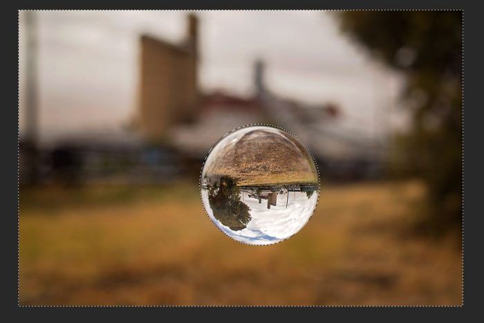
Now all you need to do is ‘Ctrl + D’ on a PC or Cmd + D on a Mac to deselect the selection and close the marching ants and make final adjustments or crop to your liking.
A word of warning
These balls can be dangerous in the sun! They concentrate the sun’s rays into a strong, direct beam of heat and light… I had seen a tripod begin smoking after just a few minutes when a ball was placed on one… and when I drove around all day with my 80mm crystal ball sitting in the console between the front seats, it melted the plastic underneath!. So always keep your ball in a cloth bag when not in use, never leave it in the sun unattended, and if you are shooting it in dry grass… work quickly!

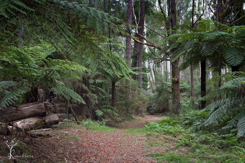
In 1930, the then Board of Works created a Redwood Forest at Warburton. This one predates the Otways Redwood Forest by about nine years.
They cleared some eucalypt trees and planted Bishop Pine, Douglas Fir, and Californian Redwoods in their place. This was done for “experimental purposes as part of the Board’s hydrology research program”. Over 1476 trees range from 20 metres to the tallest being 55 metres. I don’t know what happened to the program, but the trees are still there, unrestricted access, and the site is just magic. The site is now heritage listed on the Victorian Heritage Database, ensuring survival from logging.

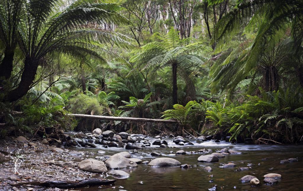
The Yarra River runs along the back of the forest…
and we headed to this first, trekking through a narrow goat track and undergrowth to find the river, and then found a wide path coming back. In the forest, none of us thought to record our Indiana Jones moment 🙁
The river is lined with lush green tree ferns, water tumbled and washed over rocks. Not a sound except for running water and the birds. We were only able to get down to the river at one point, with high banks preventing access most of the length, but the spot we found was beautiful, and we spent about an hour there.
Back in the forest, we found more ‘odd’ evidence on what happens in a Redwood Forest (on a full moon?). Dotted throughout the forest were circles made from twigs and branches and, in one instance, a small shelter. There were dozens of the circles, a couple shaped like large nests, more than a bit ‘Blair Witch’ and no way would I go in there after dark 😉
Getting there:
Drive through Warburton, following the Warburton Highway until it becomes Woods Point Road. After about 7 km, take Cement Creek Road on the left. The road is unsealed and a little rough in places, but 0.7 km along, you will find a small parking area on the right along a fenceline and small gate barrier. Walk through the gate, and there you are. Walking through the plantation will lead you down to the river, following the walking tracks each way.

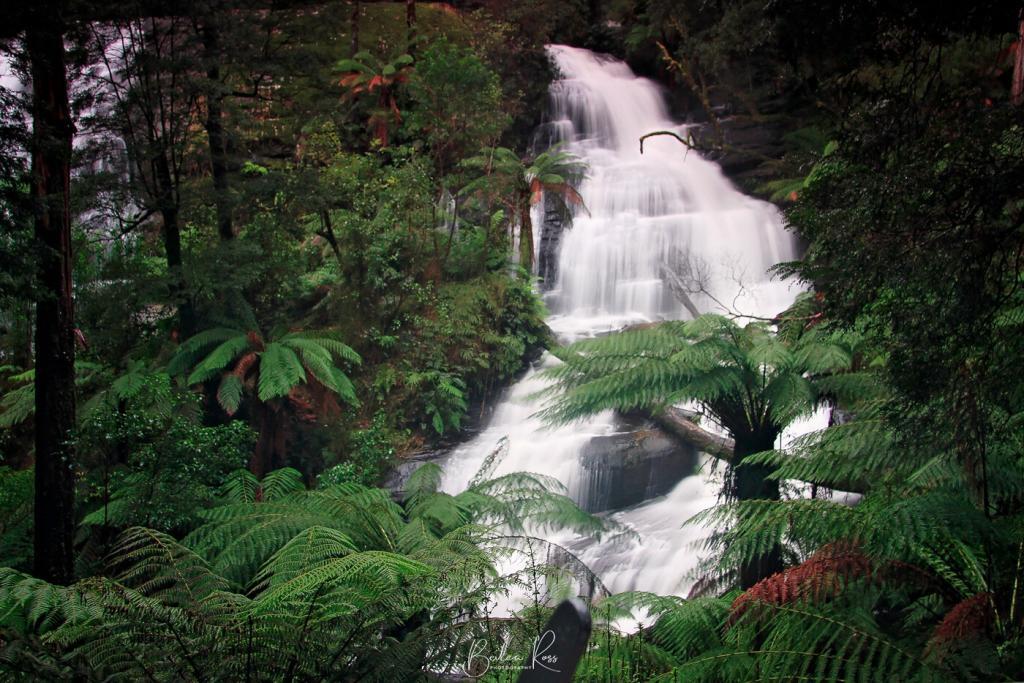
I love waterfalls and the Otway Ranges, and Hopetoun Falls had been on my wish list for some time, esp now that I have finally got my head around F stops and slow shutter speed. I haven’t mastered it, but at least now I understand the concept 😉 In June, I went down to the Otway Ranges with my sister and niece for the niece’s birthday. All Canon girls. We drove down in the sunshine, but it was pouring rain most of the day we were shooting. In a rainforest in winter, who would have thunk?
We knew it would be cold, so we were prepared with waterproof coats, gloves, and thermal underwear. But, pity, no one remembered to pack an umbrella!
We made sure we kept our cameras dry, but we were all soaked to the skin. Ah well, we dry better and with more minor damage than cameras and lenses. We booked a little cottage at the top of The Otways, which was comfortable, cosy and contained all we needed. once we got the fire going. Unfortunately, it wasn’t lit when we arrived, and it was so cold in there our breath was coming out in condensation! If you ever stay there, phone ahead and insist they light the fire for your arrival!

Hopetoun and Triplet Falls
Saturday morning, we woke to rain and mist. Our first stop was Hopetoun Falls, very photographed but very photogenic. We spent about an hour there getting wetter and wetter before moving to Triplet Falls. The walk to both falls is reasonably straightforward. Hopetoun Falls has more steps, while Triplet has boardwalks all the way in. And we found there is a short way and a long way. Hopetoun Falls is also the most photogenic of the two. Unfortunately, Parks Victoria doesn’t signpost, which is the shorter, and we spent about 45 mins walking in a long way, only to find we were about 10 mins from the carpark taking a different path back!

The Otways are beautiful and totally worth multiple trips back. Don’t go in the middle of winter like we did unless you are happy with wet conditions.

Chasing the elusive (for us) image of the Twelve Apostles at sunset, we planned another Great Ocean Road trip. This would be my second trip down there this year. The first was a complete washout (literally, as it had rained all weekend – see Wye River post). So, for this trip, we booked three nights in Apollo Bay and one at Warnambool and set off with our first stop at Teddy’s Lookout in Lorne.
Teddys Lookout
The view from the lookout was tremendous but required a walk to the lower lookout as some idiot had burnt the top lookout almost to the ground, and it was roped off. From Lorne, we drove to Apollo Bay and collected our keys. We had a lovely house right on the Great Ocean Road with a great view and easy access to the beach across the road.

We had planned to walk to Lower Kalimna Falls, but the troops mutinied partway into the walk, and we turned back about 700 metres into the hike. I was rewarded with an accommodating Kookaburra, though.
Maits Rest
The next day was a walk around Maits Rest, an 800-metre walk through the cool temperate rainforest of tree fern gullies and towering 300-year-old trees. A wooden boardwalk has been built over most of the walk to protect the ecosystem.

Cape Otway Lightstation
After Maits Rest, we drove to the Cape Otway Lightstation. The Cape Otway Lightstation is the oldest surviving lighthouse in mainland Australia. It’s been casting its light out to sea since 1848 over the towering sea cliffs where the Southern Ocean and Bass Straight intersect.

Gibsons Steps
On the third day, the good weather gods had deserted us as we set off early, heading down to Gibsons Steps – 84 steps along the cliff face, allowing access to the beach. The limestone stacks are impressive up close.
We followed this by stopping at The Twelve Apostles, The Arch, and the Loch Arch Gorge. The weather wasn’t as lovely as the day before, overcast and windy but not cold. The wind coming off the waves was kicking up massive spray along the coast.

Loch Ard Gorge
The gorge is named after a ship that foundered there in 1878. Bound for Melbourne, it hit reefs, and only two of the 54 onboard survived. The Loch Ard wreck still lies at Mutton Bird Island’s base.

After numerous stops, the troops rebelled again, stayed in the car, and played on their iPads and iPhones while we continued taking photos. That night, the last stop was Warrnambool Motel (very comfy, highly recommended) and a yummy dinner at ‘Images.’
The following day, the sun shone again, and we headed out to Hopkins Falls before starting the drive home. Stopped briefly at Inverleigh for lunch. Great little bluestone pub with super yummy food, we enjoyed a lovely meal in the beer garden (shhh, don’t tell them we used the table number as a very effective swatter on the wasps hanging around) before heading back to Melbourne.
Did we get the shot of the apostles we were after? No, not with that weather, as luck would have it was beautiful and sunny either side of the day we went. And a whiteout on the day we were there, but we are planning another trip down to Apollo Bay, just an overnighter when we know the weather will be good for two days.

One of our favourite gardens is Alfred Nicholas Gardens in Sherbrooke. We visited during the summer and made plans to return in the autumn to see the English trees changing colours.
Picnic Lunch
Expecting to spend most of the day there, we packed the cameras and a nice picnic lunch with cakes and wine and set off. The gardens are in the Dandenong Ranges, and the property is hilly and steep, as stunning as the gardens are. Very hilly and steep. By the time we got back to the car, I had wished we had packed an oxygen tent instead of the wine. However, we drank it anyway. So we were sitting on the car’s tailgate sipping wine while everyone else going back to their vehicles looked just as winded and puffed as we were.
Burnham Beeches
Originally named Burnham Beeches, it was built in the 1920s and owned by Alfred Nicholas, the ‘Aspro’ magnate. The beautiful gardens cover about 13 acres and feature tree ferns, mountain ash trees, lakes and waterfalls. Walking down to the ornamental lake brings you to a small series of islands connected by footbridges At the end of one is a small boathouse.
The gardens are alive all season long with masses of plantings. We had hoped to photograph the gardens as the leaves turned. But the unseasonably warm weather had kept everything green. So we decided on the way out that we would have to back again next year, but much later in autumn.

The Gardens
The gardens are worth a visit, but plan your day well. Unfortunately, there is no cafe on site. You need to carry everything in if you plan to eat there. Bins are scarce, so we carried our rubbish around for a while until we found one. And bear in mind, it’s a long way back up! Take the paths. They are easier than the steps! As you can see from the images, we didn’t leave it late enough in autumn to get the shots we wanted. Consequently, another trip is planned for the future.


In February, we took one of the free boat tours around the port, run by the Port of Melbourne Authority. These ran once a month out of both Victoria Harbour at the Docklands and Gem Pier at Williamstown.
Gem Pier
We chose the tour from Gem Pier because driving to Williamstown is a pleasant drive, and parking options aren’t too demanding (compared to the nightmare of navigating the docklands and paying exorbitant parking fees). I didn’t think to take a pic of the boat that did the tour, but it was VERY nice. Not a tug or old rust bucket like I was expecting, but a large, comfortable, very well-staffed private vessel that the Port of Melbourne pays to do these tours.
Cruising
It was a really, really warm morning – we were on the 11 am tour and sitting at the front in the open as it was the best spot for photographs. Some fellow passengers started wilting and moved inside, allowing us to move closer to the show. We were fading too, but stoic. I wanted those pics and knew the breeze would make it about 10 degrees cooler upfront once she started moving, which was the case.

Webb Dock
The Williamstown tour takes you to Webb Dock. Seeing those enormous container ships and the cranes operating and moving the containers around was terrific. Those ships and containers are HUGE, and to watch the cranes move them around like dominoes was a highlight.

HMS Castlemaine
After the cruise ended, we took a walk around the HMAS Castlemaine. She’s a mine sweeper permanently berthed at Gem Admission was $6 per adult or $15 for a family. Although it was an exciting learning experience to wander around the ship, the staff volunteers advised us to go down the stairs backwards. And I can tell you few hail marys were said when we looked at them and descended, and we’re not religious. The steps were about as wide as a 3″ plank and went down at about a 70-degree angle!

The engine room required about three lots of take-your-life in-your-hands stairs but was worth the descent. I loved the old dials and machinery rising and dropping up and down as it ran.


Highly recommend both the Port of Melbourne tour and the HMAS Castlemaine.
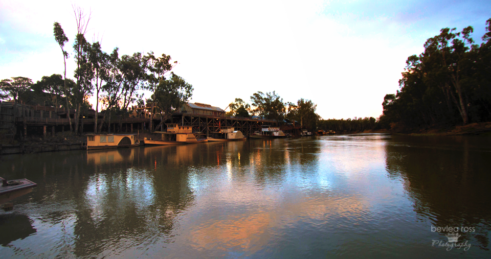
The historic Port of Echuca is nestled along the picturesque banks of the Murray River in Victoria, Australia. This riverside town is steeped in rich maritime history and offers visitors a glimpse into Australia’s bustling river trade of yesteryears. Echuca was established in the mid-1800s during the height of Australia’s paddle-steamer trade. The Port of Echuca played a pivotal role in transporting goods and passengers along the Murray River. Today, Echuca’s heritage buildings and bustling wharf area are meticulously preserved and serve as a living museum, inviting visitors to immerse themselves in the sights and sounds of the past.

History
Echuca was founded by Henry Hopwood, a former convict, in 1850. Hopwood purchased a small ferry to transport people and goods across the Murray River near the Campaspe junction. The settlement, initially known as Hopwood’s Ferry, later became the town of Echuca. The Hopwood’s Punt Post Office opened around 1854 and was renamed Echuca Post Office in 1855. One of the main attractions of the Port of Echuca is its authentic steam-driven sawmill. The sawmill showcases the power of steam as it cuts the timber, just as it did over a century ago. Additionally, the Port features a collection of beautifully restored historic buildings. These include the Echuca Wharf, the Customs House, and the Port of Echuca Discovery Centre.
Paddle steamers
A visit to the Port of Echuca is incomplete without a relaxing cruise on one of its famous paddle steamers. The PS Emmylou, or the PS Canberra, will take you on a nostalgic journey down the mighty Murray River.

Sunday morning, the rain had thankfully stopped. We decided to go to the Port early in the morning to get some river shots as the sun rose. The Port Precinct is home to the world’s largest paddle steamer fleet. This includes the world’s oldest operating wooden hulled paddle steamer, the PS Adelaide, built in 1866. Many of the old original buildings are still standing. And a stagecoach you can ride pulled by this lovely pair of greys.
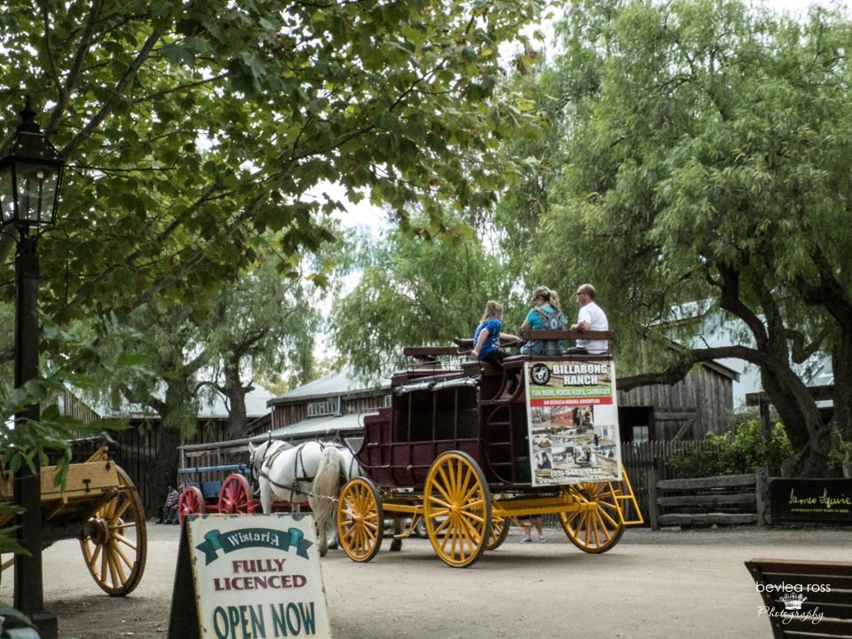
We took the ride. Kudos to the pioneers. I didn’t realise how awkward climbing in and out of the old coach was. I don’t know how the ladies of the 1800s managed in long dresses and corsets!
A visit to the historic Port of Echuca is more than just a journey through time – it’s an opportunity to connect with Australia’s rich maritime heritage and experience the beauty of river life firsthand. Whether you’re drawn to the nostalgic allure of paddle steamers, the captivating stories of the past, or simply the tranquil beauty of the Murray River, the Port of Echuca promises an unforgettable adventure for visitors of all ages. So, step back in time and prepare to be captivated by the timeless charm of this riverside gem

Monday, we woke to wonder where our sun had gone. It was still warm but quite overcast and cloudy. But, as was ‘de rigueur’ of our days, we were up, fed, showered, car packed and on the road by 8.30 am (a bit of a sleep-in today). Today, we travelled from Broken Hill to Menindee and had a van booked at the Menindee Lakes Caravan Park. Menindee is 112kms from Broken Hill so that it would be an easy run. We filled the tank before we headed out (driveway service, too! I haven’t seen that since 1920!)
Road Kill abounds
The road from Broken Hill to Menindee was excellent, with a single lane each way and little traffic. What little we did see was kept to 110 km; there was not a slow caravan in sight. We were seeing so much Road Kill that we started counting it. If you’re planning a trip from Broken Hill to Menindee – it is a 16 RK (RoadKill) trip 🙂

We saw lots of dead roos. Seriously, it’s not a busy road. Can’t they wait 2 mins till the car passes. or look left? I came around one corner and across a dead wild mama big and piglet, two roo’s and a lizard – talk about dead man bend. I hope it wasn’t just one car that collected them! Loads of floodplain signs along the road and depth markers for the water, but nary a drop of water is in sight. And passed quite a few dry creek beds.
Menindee
We arrived around 10 am and called in at the general store for bread… “that’s delivered at 11 am. Do you want me to save you a loaf?” umm ok, then over to the supermarket. “do you have any fresh meat”? “no, that’s delivered tomorrow” Sheesh, save me from tiny towns! We found our caravan park with directions from the general store with no bread. We unpacked and looked around. 5mins that was done. So we made lunch with the last of our bread and sliced meat. We decided to check out the Kichega National Park.
Kichenga National Park

I had heard lots of good things about Kichega. However, It is definitely a 4WD place only. Dirt roads are everywhere, even though they said it’s 2WD, and they are BAD dirt roads. I thought we were going to shake the car apart. We did stop off at the Kichega Woolshed, which was great, except for the very friendly swarming flies. That drove us back to the car pretty quickly and smartly. I would have hated it out there in the 1800s

Kichega Woolshed
Remarkable for its size and design, the Kichega woolshed was constructed in 1875. It illustrates the vast scope of pastoral holdings in the arid areas of inland Australia. Kinchega lies amongst the beautiful Menindee Lakes, fed by the Darling River amid forests of river red gum, coolabah and black box trees.

I had been driving that morning – letting my sister take it easy as she still wasn’t 100%. But she took over as we left as she wanted to get out of there and felt I needed a break while we drove around in circles for a while (no signs) along shuddering, bone-jarring dirt roads. We had visions of our whitened bones being found years from now. Eventually, we found the exit and returned to the general store to claim our bread. Last loaf, lucky she saved it, and bless her, she also had roast chickens to take care of dinner. We returned to the cabin and chilled out reading for a while, which turned into nana naps for all of us.

Sunset on the lake
Towards sundown, with more directions on the best spot to photograph the lakes, we headed up the road. “go up the bitumen, cross over the channel, and turn left at the first dirt road. There’s no sign. Drive to the end. You can’t miss it. Sure. They don’t know us! We missed it, turned left at the dirt road after the creek (thinking that was the channel) and took the first dirt road to the end. Parked the car, walked across the railway line and to the water… fab spot! I could see where we were meant to be, but this one was good!

The light was amazing. Almost naturally monochromatic. It had been such a dusty day that the sky was full of dust, creating total haze across the sun. On the side of the channel we were on, the other side was a weir with water spilling through the channel into the lakes. Lined up at the weir was a back row of pelicans. And a front row of Seagulls, all waiting for the channel to spit out dinner. A little silvery fish would come through and down the spillway every few minutes, and they would dive on it. It went on for ages and was hilarious to watch 🙂 Gradually, the light changed as it got darker, and bearing in mind all the roadkill we had seen thus far, we packed up and headed back to the cabin before it got totally dark.


The cabin beds were comfy, and the shower was ‘ok’ (rain tank, no water pressure), but we were fed, showered and comfy, and in bed again, lights out by 9.30. tomorrow was back to Mildura.
