
Tag:photography

Sunday was going to be warm – but a bit windy (‘significant breeze’, a Broken Hill local called it). So we were off to Silverton and the Living Desert Sculptures. After a quick breakfast, we were on our way by 9 am.

Silverton
About 25kms outside Broken Hill lies Silverton, a little ‘ghost’ town. The town sprang up in 1867 with the discovery of silver, but when more extensive deposits were found at Broken Hill, the population moved there. It now has a permanent population of 89 and is a major tourist drawcard. Mad Max and many other films were shot in and around Silverton and the Mundi Mundi Plain.

Mundi Mundi Plain
The local donkey here wanders the town. We came across him again about an hour later on the veranda of one of the cafes. (I half expected to see Clint Eastwood step out from behind the building 😉 Silverton is a very popular place, and according to the publican, Sunday is his busiest day. Even though we were there by 9.30, the area was still busy with cars and bikes. 5kms further down the road is the Mundi Mundi Plain, where the land is so flat you can see the earth’s curve.


Living Desert Sculptures
After lunch, we returned to Broken Hill for a brief siesta before returning to the Living Desert Sculptures. Fantastic place, busy too. There was even a coach bus up there! I would have loved to have been able to see it without the crowd. One chap had a humongous video camera on a tripod to catch the sunset. He was hogging the best spot. Everyone is trying to shoot around him. Artists worldwide created the sculptures in 1993, which sit atop the hilltop in the Barrier Ranges.


I love this place and highly recommend it if you are in the area. After leaving the sculptures, we returned to town and enjoyed a lovely dinner at the Demo Hotel. Then, it was back home, and the lights were out by 9.30 pm. We have to go to stop getting up so early!

On Saturday and day two of our Broken Hill or Bust road trip. We were heading from Mildura to Broken Hill. We had a bright, beautiful, sunshiney, warm day ahead. Body clocks were off-kilter from the early start the day before. We were all up by 6 am again. We had a leisurely breakfast in our motel room and headed into town. I checked out a few shops, had morning tea at Gloria Jeans, and then went to the wharf for our paddle steamer cruise.

Paddle Steamer Cruise
We cruised on the Rothbury for two hours upriver, past loads of other paddle steamers moored along the banks. The river was well down, though. We travelled up to Lock 11 and back. Refreshments on board (the short person was happy), souvenirs available (the short person was very happy). Going through the lock was enjoyable (but slow) had never seen one in operation before. Seeing the boat rise and fall with the lock workings was quite quirky.

While we enjoyed our cruise, two hours on a slow-moving boat is as bad as six hours in a car. It would have been much more enjoyable on a one-hour cruise. But still fun. We were back in Mildura by 1 pm, in the car, on the road, and off to Broken Hill.
Getting There
Famous as the birthplace of BHP Billiton, Broken Hill is an isolated mining city in the far west of outback NSW. It holds the distinction of being Australia’s longest-lived mining city. Sitting almost on the border of South Australia, in the Barrier Ranges, Broken Hill is reached by the Barrier Highway to South Australia and Silver City Highway to Victoria. It is 844kms from Melbourne, 500kms from Adelaide and 1100 kms from Sydney. We had chosen spring to visit as its average temperatures in summer are well over 40c (104F)

The road is good and had a surprising amount of traffic on it for something that appeared so isolated. We passed many cars travelling in both directions, not bumper to bumper. We did stop about halfway for a quick cuppa and biscuit. As there was not ONE town or service centre between Mildura and Broken Hill, we had packed our own. However, the stop was brief as flies would pick you up and carry you away!
Isolation
Mobile reception is almost non-existent once you leave Mildura. And we didn’t get service back until we were about 6kms out of town, so the passing cars were very reassuring. However, it felt like Wolf Creek country, and we hoped if we broke down, we wouldn’t be helped by John Jarret.
We made good time and arrived in Broken Hill around 4 pm. #1 sister had started feeling ill on the drive, so after we met our lovely hostess from Jaden Cottages at our new home, the short person and I unloaded the car and settled in while she showered and rested on the couch.

Not in the plan
Our new accommodation was a three-bedroom house with a lovely little backyard. It had a well-set-out kitchen with supplies and very comfy beds. However, the couch resting wasn’t helping. And, as all doctors in Broken Hill seemed to close at midday, we added Broken Hill Hospital Emergency Dept to our must-see places. We waited about an hour in the waiting room before they took her through to a hospital trolley for treatment. Not too bad, considering. But they only had one doctor on and were slammed with an emergency case. The poor patient was wired up to equipment looking like a supercomputer. The nursing staff and doctors were stabilising them while they waited for transfer via Royal Flying Doctor Service to a major city.
Short person and I left her there and returned home to wait it out. She returned home around midnight via a cab. All patients discharged out of hours are sent home via a taxi paid through medicare. What a fab idea! Loaded up with lots of pills, we tucked her into bed and settled down for the night. The next day, we were off to Silverton.


I do love road trips. Add the fun of planning, packing, and looking at new things out of the window along the way—the different cuisines or lifestyles when you get there. And Melbourne to Mildura and Broken Hill was our most ambitious yet!
Travelling with kids
While this one, our fantastic ‘Broken Hill or Bust’ goal, was still a great success. Travelling with a nine-year-old does limit your patience ‘chi’ a tad. They talk. Constantly, and while we didn’t hear one single “Are we there yet” or “How much further?” having been pre-warned under sentence of dumping by the roadside ahh no ice creams for a day. We still had constant fidgeting, the rustling of lolly bags (maybe it was the sugar high), and many “I’m thirsty, hungry” on the long legs. Next time, leave the short person at home or plan shorter hops. Six hours in a car is just too much for a kid to bear 🙂
Mildura

We were all up by 6 am, on the road by 7 am Friday in horrible drizzling rain, and rugged up in warm clothes. Our first overnight stop was Mildura, which we hoped to make by 1.30 pm, giving us time to take a paddle steamer cruise. After stopping for coffee, photo, or loo breaks every few hours, we soon realised we had significantly estimated our travel times. We wouldn’t be there in time, and our paddle steamer cruise would have to be the next day. As we headed further north, the weather got better, but the wind was chilly, so the coats never came off until we were almost at Mildura. But from there on, we were basking in sunny skies and warm weather for the rest of the trip.
Accommodation Problems!
Once we arrived at our accommodation, we encountered the first significant hiccup. Our booking wasn’t on the books. I always travel with my accommodation confirmations printed. Upon checking my paperwork, we were definitely due. However, on theirs, no. Thankfully, the lovely proprietor had one room left, making us very comfortable and welcome. I then phoned ahead to Broken Hill, and we weren’t expected there either! To compound the issue, they were fully booked. However, they could accommodate us in another holiday rental owned by a relative. Thus, we didn’t drive all that way and slept rough.
Accommodation issues resolved. We were soon in sleeveless tops and sipping chilled wine. The short person headed for the pool and returned quickly, slightly disgruntled. She couldn’t swim in it as it needed cleaning after the previous night’s storm. We ran into town that night for dinner and dined at Stefano’s near the Mildura Wharf. The staff were lovely and accommodating (we found pleasant staff and service people throughout our travels).
Stefanos, Mildura
My travelling companion on this trip was my #1 sister. As she had been ill with the flu and tummy troubles leading up to the trip, we decided to play it ‘safe’ menu-wise. We had the dipping bread with oil and balsamic, calamari, garden salad, and the obligatory Sauvignon. The short person ordered the child’s eye fillet with salad. Our meal was lovely – but nothing to write home about (yet I write here, lol). The child’s steak was cooked well done, but we assumed that being a child, they figured they wouldn’t like it rarer, so we gave them a pass on that. Calamari was lovely and tender and service attentive. We were well and truly fed, watered and tired from the long day and were all in bed lights out by 9.30 pm.

I tried previously tried, to persuade Lucy to make The Great Ocean Road and Apollo Bay the focus of one of our weekends. The road is constantly referred to (by Lucy) as the “Great Scary Great Ocean Road” and a refusal to contemplate the thought of driving it. She finally succumbed to my begging and tantrums well-considered argument. And we booked a lovely two-bedroom unit in Apollo Bay with ocean views.
History
The Great Ocean Road is a “Heritage listed 243-kilometre (151 mi) stretch of road along the south-eastern coast of Australia between the Victorian cities of Torquay and Warrnambool. Built by returned soldiers between 1919 and 1932, it is the world’s largest war memorial dedicated to World War I casualties. It is also an important tourist attraction in Victoria.

The scary part comes into play as it hugs the cliffs, bending and twisting with white knuckle S-bends as it winds it’s way through varying terrain alongside the coast. It is a single-lane road with nowhere to overtake other cars, save for a few cutouts where people can pull over and allow others to pass. There’s also the sheer ocean drop to consider. Hence, her rampant paranoia is an understandable concern. However, the Great Ocean Road also provides access to several landmarks, including the nationally significant Twelve Apostles, a series of limestone stack formations.” There is a short excellent video history of the road HERE that’s well worth watching.
Erskine Falls
Our trip down started in the sunshine on Friday morning. A tad cold, but beautiful sunny blue skies. We stopped off in Anglesea for an early lunch and continued. There was a brief stop at the Split Point Lighthouse at Aireys Inlet, back in the car on into Lorne and then up into the hills to see Erskine FalUnfortunately, ls. Unfortunately, I had left my glasses in the car – so I didn’t get the best shot as I could hardly see the settings and was NOT going back to the car to get them! According to Parks Victoria, this was classed as a ‘moderate’ walk.

Three hundred twenty steps down to the falls mean 320 back up. It was touch and go as to whether we would MAKE it back up. I took lots of wheezy breaks trying to suck air into my burning lungs. Legs wobbly and refusing to go up another step. If we had mobile reception, we might have been tempted to call in the rescue chopper! 😉

From Lorne, we continued to Apollo Bay, collected our house keys and walked around the harbour. After enjoying the sun at the port, we headed back to our unit, ramped up the heating and settled in to do some art. Working on our journals, ATCs for a swap etc.,

Cape Otway Lightstation
The following day the sun had left us – it was very overcast and windy, but no rain was predicted, so we headed to the Cape Otway Lightstation. Driving along the road, the trees suddenly all looked stripped bare. It was a very odd sight. Then, we came across the culprit a bit further down the road. There is quite a large koala population. I don’t know what they plan to do when the food runs out cause the cupboard is bare!


Cape Otway Lightstation is the oldest surviving lighthouse in mainland Australia and has been in continuous operation since 1848. Life must have been terribly lonely and bleak there a hundred years ago. Cape Otway Lighthouse is perched above massive cliffs where the Southern Ocean and Bass Street collide, and it’s no summer picnic. Great view, but wind-swept and bitterly cold. However, spotting the cafe, we took refuge there for a serving of fresh scones with jam and cream and steaming hot coffee. After the climb to Erskine falls, we didn’t do the lighthouse climb. Though, compared to split point and Erskine, it would have been a breeze (it’s not that tall due to the height of the cliffs it sits on)

Gibsons Steps
From Cape Otway, we then drove towards Port Campbell. Gibsons Steps was our next stop. They are just before the Twelve Apostles and were initially a series of steps cut into the cliffside by Hugh Gibson (so he could get down to the beach to fish). They have since been replaced by 84 concrete steps – down to Gibsons Beach. Once on the beach, the limestone cliffs tower above you. Leaving Gibsons Steps behind, we were off to the Twelve Apostles. There are seven of them, not twelve (there have never been twelve). It was getting very grey with threatening skies. The sun came out briefly for a few mins at a time – but we could see a storm coming – and Sunday was predicted to be quite wet.


Twelve Apostles
From the Twelve Apostles, we went into Port Campbell for lunch. Apart from the pub, a cafe and servo, Port Campbell seemed to be closed. I expected it to be bigger, and for 2 pm on Saturday, it was deathly quiet and empty. We ate at the only cafe open – meals took almost an hour to arrive, and I was ready to walk out except that Lucy was chewing the table legs in hunger.
Once we wolfed our meal down, we headed back to Apollo Bay, bought dinner provisions, and returned to the unit just as the rain started. We had a good thunderstorm that night and brief sunshine again Sunday morning before the heavens opened again, and it kept raining quite heavily all day. So it’s a day for staying in and arting.

As had been the case every time we went away – Monday was bright, sunny and very nice in the sun. We left Apollo Bay a little before nine. I ate breakfast in Lorne and walked along the beach and through the rock pools. All in all, a delightful weekend. Our accommodation was very comfy. The weather was kind to us (considering it was winter, after all). We did art, ate junk food, talked, laughed and had a wonderful time.
Footnote:
In the months following our visit to the Cape Otway Lightstation, a secret koala cull was commenced to deal with the overpopulation. For more info, you can see the article Here.

Take One:
We planned a weekend away to Ararat with an Aradale Lunatic Asylum and J Ward visit and a side trip to The Grampians/Gariwerd. But, as they say in the classics, the best-laid plans of mice and men often go astray. Add women to that, too, vbg.
Gariwerd
The aboriginal name for the Grampians is Gariwerd. Gariwerd is a highly spiritual place for Aboriginal people due to the dreaming stories and the abundance of food, water and shelter it provides. This is evidenced by the number of occupation sites found in Gariwerd and that even today, Aboriginal people are drawn to this place. The Grampians/Gariwerd has the most significant number of rock art sites in southern Australia and over 80% of Victoria’s rock art sites.

Waterfall Hunting
We headed up the Western Highway towards Ballarat, veered off towards Horsham, drove through charming and quaint Beaufort (plan to go back there, lots of old photographic worthy buildings), lunched at the Cottage Garden Cafe in Beaufort scones with jam and cream. Yummy. We arrived in Ararat around 12.30 pm. As we couldn’t book into our accommodation until three, we decided, armed with all the maps, directions, and info from the Internet I had printed out, plus Lucy’s Tom-Tom, to head off and see a waterfall.
Mackenzie Falls
Initially, the plan was to see Mackenzie Falls, but as the Parks Victoria site said, the waterfall’s base was closed due to storm damage, and it’s not worth seeing a waterfall just from the top. So we drove off looking for Beehive Falls. And we’re still looking an hour later.
Backroads
Like the fabled Utopia, it’s out there somewhere but hidden behind the mists of time and lost travellers. We drove down Roses Gap Road (dirt road all the way) for over half an hour, stirring up a massive dust cloud behind us, and never found the ‘Roses Gap Car park that was on that road (according to the directions printed out) and never found Beehive Falls.
We did see some great views of the Grampians as we drove its length and breadth. But that’s as close as we got 🙁 As it was by now, around 2.30, we turned around and headed back to Ararat. After a brief but obligatory stop at MacDonald’s for a late lunch, we arrived at our cottage around 4 pm and loved it on sight.

Golf Links Retreat
We were greeted by our very hospitable hosts, Merren and Peter, who introduced us to the gorgeous cottage Golf Links Retreat we were staying in. Set in beautiful gardens, it’s a Bluestone brick exterior, old exposed brick walls and timber ceilings inside, a two-storey, three-bedroom, two-bathroom, breakfast basket, and Coonara heater. Heaven!!

We took the princess, too, and she took it straight away. It was ‘home’ for three days, and that’s just what it felt like. Home. We plan to go back and find those waterfalls next time, too!

Aradale
As Saturday was very wet and rained ALL day, we decided to stay in and do some ‘arting’. We took supplies with us and spent the day making gazillions of chipboard tiles that we would adhere to large canvases. Sunday was just as overcast and cool. But only brief showers, so we decided to head off to Aradale Mental Hospital. It started life named Aradale Lunatic Asylum. Take the tour (the link will give you all the info on it)

The outside was a beautiful, huge, massive complex of around 70 buildings. But inside, it had suffered from renovations in the ’50s and ’70s and wasn’t what I expected. It was more interesting once we got into the older parts.
J ward

Monday, we were heading home but stopped off and took the tour of J ward. J Ward started as a goldfields prison in 1859, and when the gold ran out, the ‘Lunacy Department’ (I kid you not) acquired it as a prison for the criminally insane. It housed the most dangerous and violent offenders deemed unfit due to mental issues to stand trial. They were detained at the Governor’s pleasure under the highest security (and lowest conditions). One famous inmate was Garry David Webb.


After our tour (very interesting with a very informative guide), we continued our journey back home. But, as I said, we plan to return to Ararat and the Golf Links Retreat to find those waterfalls and take the ghost tour of J ward!
Take Two:
Waterfall Hunting Again
Lucy and I returned to Ararat armed with better maps and a goal to see a waterfall in the Grampians finally. We had taken a wrong turn last time and travelled miles on a dirt road. This time, we were prepared. We drove straight to Halls Gap on Friday and saw Reid’s Lookout, The Balconies and a little McKenzie Falls (the track to the base was closed). However, the path to Broken Falls was open and more of our style (suitable for the fitness-challenged).
Broken Falls

The Falls are quite pretty, and I could see why they were named Broken Falls. The water plunges over the top but splits into several separate falls. Unfortunately, getting a good shot from the viewing platform was hard because quite a few trees blocked our view.
Watching the world go by
We were booked in at the Links Retreat B&B again, a charming little bluestone cottage alongside the golf course..we’d sit on the veranda and watch the golfers go by and putt around the kangaroos who were lifetime members. We took our art journals to work on, two big suitcases of supplies, and a small bag of clothes each. I should have taken a pic of the table as we worked on them. Maybe we did not think our hosts would have had a heart attack at the mess we made (but we cleaned up before leaving).

McKenzie Falls Again
We returned to the Grampians – Gariwerd and McKenzie Falls via Stawell for breakfast on Saturday. It was a sunny but cool morning, but unfortunately, it was raining quite a bit up in the hills, and I didn’t get a shot of them (Lucy did use my tripod, which we were sharing, but the rain came down in buckets as she finished so we packed it in) and we returned to Ararat for lunch. At least, that was the plan.
Unfortunately, Ararat shuts at 1 pm on Saturday. Almost nothing is open. There were no nice cafes except for MacDonald’s, which we were sick of. So we ate a lovely Subway lunch before returning to our cottage to art for the rest of the day.
Sunday in Ararat’s bustling town of 8200 very sleepy people, it seems Ararat was deserted and dead at 11 am. Few shops were opening, but there was minimal Sunday trading in Ararat. Of course, it’s not the world’s end, but you can see it from there.
One Tree Hill
Sunday night, the sun shone, so we headed up the road to One Tree Hill, an odd name for something covered in trees, but that’s country folk for you. We timed our visit to coincide with sunset; the view was beautiful.

Monday morning, I was back on the road home. Our art journals had quite a few pages done. We had a lovely time. And we made two new resolutions. First, never visit somewhere with lousy internet access; second, make sure the town stays open past 1950).


If we were disappointed with Saturday’s weather, Sunday was worse! The day was overcast, with a hint of rain in the air and a bit breezy. Of course, today was the day we had planned to go to Cape Schanck Lighthouse, Rosebud. There’s nothing like a walk in the rain and the wind when you are right on a surf coast. An area that’s usually windy on even a nice still day! 🙂
Lighthouse Tour

After breakfast in Flinders, we drove back through the rain to Cape Schanck Lighthouse, Rosebud. They do lighthouse tours there on the hour and even give discounts to seniors 😉 So we booked that and then went for a wander. I have never been to England, but I can now relate to all the books I read where they described wild, windswept, bitterly cold moors and coastlines. When the lighthouse keeper arrived to unlock the door and take us up to the top, our teeth were chattering, and I felt like a popsicle! We had dressed warmly, but nothing could keep the icy wind out.

Interior of Lighthouse
The inside was quite cosy. A small, winding, and very narrow stone spiral staircase led up to the top. This is unusual for a lighthouse, as the usual steps were wrought iron. From the top, you could go out the door and view the world from the top of the lighthouse on the top of the cliff ;). On the sheltered side, you had views of the lighthouse grounds. On the other side, open to the ocean, the wind nearly blew you off your perch.

Back inside the little wood-panelled heart of the lighthouse, where we learnt it was constructed in 1879 from limestone, the beam goes out about 50 miles and protects the shipping going past Seal Rocks. The colossal crystal lens is worth 3.5 million.
The lighthouse is automated now, but in the days gone by, it was hand-operated by a series of pulleys that kept it turning. Wind the big wheel up 87 times, and it would slowly unwind over the next hour and a half, then wind it up another 87 times for the next hour and a half, over a ten-hour shift that’s 579 turns of the winch. It seems one thing a lighthouse keeper of old didn’t suffer from was weak biceps!:)

The Boardwalk
After the lighthouse, we wandered over to the Boardwalk. This spectacular timber structure hugs the cliff tops and sides as you walk along.

There are several lookout spots along the way to take a pic or rest. We had planned to walk this, then changed our minds when we became popsicles. However, since warming back up from our time inside the lighthouse and with the sun trying its best to peek out, we changed our minds once again and decided to brave it.

Pebble Beach
From the top to Pebble Beach is 1.7 km, downhill all the way. Which meant coming back up would be 1.7kms UPHILL all the way. Something we didn’t consider as we set off. We made it down in good time, looked around, and watched the surf fisherman on the rocks and a hardy soul trying to surf. Then, I started the journey back up. We did it in only a slightly longer time than the downward journey but nearly expired on the way.
Mental note: next time, pace ourselves and take a bit longer to get back up! We felt very proud of ourselves, though, as we were passed many times on the way up and down by people much younger. And they stopped halfway and turned around.

We would have bought one if they sold an “I Survived the Boardwalk” badge at the kiosk. We wanted our medal!
Mornington
After we got our breath back, we headed back to the apartment. Our legs felt like lead, and we looked forward to an LLD (little lie-down!) LOL
‘Twas our final day. We head back to homes, doggies and family today. And, of course, the sun was out. The skies were blue. Glorious weather. We left around 10 am and headed to Mornington for breakfast. Then, a short stop at the Mornington Boat Harbour and a slightly longer stop at Paper2, arriving back home around 2.30

We had a fab time. We laughed a lot, made fun of each other, ate all the wrong foods, drank too much wine, walked over 10kms on the weekend (we kept track, lol), and still created art at night.

The Wimmera Silo Art Trail is planned to be 200km long and lies within the Wimmera Mallee Region. The Wimmera is a large, flat region in the North West of Victoria, regarded as Victoria’s agricultural heart. A significant proportion of the world’s wheat and barley is produced in the Wimmera. The wheat silos dominate the landscape of every town, small and large.
Horsham Overnight
We drove up from Melbourne the day after Boxing Day, staying overnight in Horsham near the start of the Wimmera Silo Art Trail. The weather in Melbourne had been somewhat erratic, with a scorching hot Christmas day and a mild and wet Boxing Day. Driving up, we had rain on and off all day, but the temps were still pleasant. Leaden grey skies are not my favourite photographic background, though, and we had our fingers crossed we would get blue skies the further north we drove.
Grey Skies
We woke to more grey skies, and it rained the following day. The weather forecast was rain and high winds. Loading up the car in the rain as we booked out, it looked like we would have a wasted trip. I wanted fields of yellow grass and blue skies! Leaving Horsham, we passed through Dooen and Jung and stopped briefly to shoot the silos. Our goal was to shoot as many silos as possible.

Just after leaving Dooen, the heavens opened. We were photographing train tracks and silos in the rain, attracting confused looks from cars driving past.


From Dooen, we drove to Jung, a tiny town with a population of 246 and just 18 km northeast of Horsham. The name came from the Parish of Jung Jung, derived from an Aboriginal expression of uncertain meaning but ingloriously recorded as meaning a big mess in some places.


Murtoa
While still a small town, it was much bigger than tiny Jung and boasted a population of 991 in the 2011 Census. Murtoa comes from a local Aboriginal word meaning “home of the lizard”. The silos at Murtoa can hold 400,000 tonnes of grain and is Australia’s largest inland receival centre. Before long, we were getting occasional breaks in the cloud. Then, finally, we were getting some sun and patchy blue skies!

Rapunyup
Next stop, we were heading to Rapunyup. The name is an Aboriginal word meaning ‘branch hanging over the water. With a population of 549, we weren’t expecting a metropolis. But Rapunyup, like the towns before it, was deserted. I beg to differ on the “town with a pulse”. We started to feel like we were heading the wrong way. Had everyone left town for the city? Had there been a warning of an approaching zombie apocalypse?


Leaving Rapunyup behind, we headed to Minyup. While Minyip has no painted silo and isn’t part of the Wimmera Silo Art Trail, it’s a town you must go past to get to Sheep Hills. With a population of 667, Minyip’s claim to fame is the town where they shot the Flying Doctors TV series, with the senior citizens centre becoming ‘coopers crossing flying doctors base’. ‘Minyip’ means ‘ashes’ in the language of the local Aborigines.

We left Minyip and headed for Sheep Hills with a quick stop at the Nullen Sidings. By now, we had glorious blue skies and puffy white clouds, and the temperature was climbing and sitting at around 35C.
Sheep Hills
Sheep Hills had a population of 189 in 2006, and no population was recorded in 2011. Not sure what the significance of putting a silo there is. Graincorp, the owner of all the silos, closed the Sheephills silos in 2003, so maybe that is why there is no population there anymore. The Wimmera silo art trail starts at Sheep Hills, as Rapunyup wasn’t ‘online’ yet. The Sheep Hills silos are painted by Matt Adnate, an internationally renowned Melbourne artist. Matt is well-known for the indigenous portraits on walls and canvas.


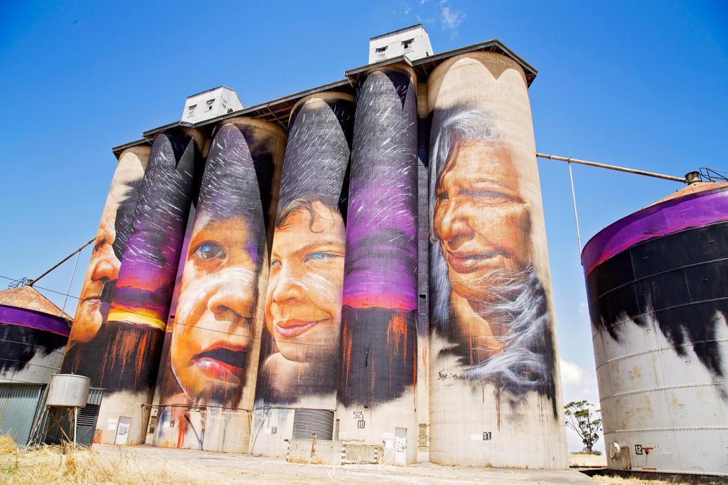
Our next stop after Sheep Hills was Warracknabeal for lunch and a stretch of the legs. The weather was a balmy 38C with blue skies. While Warracknabeal was a much larger town, it still had a closed-up look about it the day we were there. Nevertheless, we found one fish and chip shop open and enjoyed a delicious lunch.
Then we headed off again towards the next one with a quick stop at Galaquil to shoot each other on the deserted rail line. We were thanking our planning on bringing insect nets for our hats. We learnt very quickly to put them on BEFORE getting out of the car. The flies descended in their millions as soon as we got out, though; for the pics below, we sucked it up and worked quickly 😉
Brim

With a population of around 260, no pub, no school, Brim is a tiny town on the Henty Highway just north of Warracknabeal. The locals hope the tourists will come now that they have the silos. Painted by Brisbane artist Guido Van Helton, they were the first silos to be painted. The silo was initially planned to be the only one. However, such interest in them was that five more towns were added, and the Silo Art Trail was born.
Between Brim and Patchewollock, we drove into Beaulah, another silo, another abandoned railway line with a quietly decaying station. The insect net and hat went on, and we wandered around the station, giving the crystal ball a workout.
Patchewollock

We were nearing Sea Lake, our overnight destination. Our last stop before our evening destination was Patchewollock. The silo’s here were painted by Fintan Magee, and like the Brim silo, they depict a local farmer. A tiny town on the edge of the Big Desert in the Mallee, it’s reportedly to have a population of 431, but I have my doubts. Unfortunately, Patchewollock had a couple of closed stores, a park and no internet access. This was a minor disaster because we relied on our phones for navigation. It necessitated a drive back in the opposite direction for about 30 km to reconnect, get Sea Lake on Google Maps, turn around, and head back again.
Sea Lake
When we arrived at Sea Lake, the temperature was firmly settled at 40C. We were booked into the Sea Lake Motel, but they had lost power with the high winds that afternoon, so the aircon hadn’t been on long. As a result, the room was just as hot inside as out. Before leaving our room, we ensured the aircon was running well and went to the pub for dinner. Unfortunately, they didn’t have the aircon on either. I don’t think they had aircon, period. Meals were typical country fare (deep-fried and overcooked), but the beer and wine were cold and cheap.

Following dinner, we headed to Lake Tyrell. The lake was just about dry, with a few puddles too far off to reach. The wind was blowing a gale. I set the tripod up but hung onto it for dear life to stabilise it. I managed a couple of shots of the setting sun before I gave up and dived back into the car’s safety.
Dimboola

The following day was overcast again with showers. We were heading back to Melbourne via Jeparit and Dimboola. The Dimboola pink salt lake is just beautiful, and while we did stop at a few other small silo towns on the way, we were under the pump to get to the airport for my travelling photographer friend to catch her flight home. We ended up getting there with about 20 minutes to spare. Fortunately for her, her flight was delayed due to the storm that hit us as we drove down.

We covered just over 1,000 kms, driving through wind, rain, blazing temps, storms, and flies. Fortunately, we didn’t encounter any snakes. If you decide to do the Silo Art Trail Rapanyup, Lascelles and Rosebery will be completed by mid-2017. Make sure you have hats, sunscreen, bug spray, insect nets for your hats, and lots of water and snack supplies in the car.

A lot of the little towns aren’t exactly open for business. So, keep an eye on the fuel gauge. Many towns don’t have a petrol station, so fill up in Horsham, Sea Lake and Dimboola. And take a map, as your phone maps won’t work in Patchewollock. (Then you’ll be in the middle of nowhere without a clue like we were).
